
Kankakee County, Illinois facts for kids
Quick facts for kids
Kankakee County
|
|
|---|---|

|
|

Location within the U.S. state of Illinois
|
|
 Illinois's location within the U.S. |
|
| Country | |
| State | |
| Founded | February 11, 1853 |
| Named for | Kankakee River |
| Seat | Kankakee |
| Largest city | Kankakee |
| Area | |
| • Total | 681 sq mi (1,760 km2) |
| • Land | 677 sq mi (1,750 km2) |
| • Water | 4.8 sq mi (12 km2) 0.7% |
| Population
(2020)
|
|
| • Total | 107,502 |
| • Density | 157.86/sq mi (60.95/km2) |
| Time zone | UTC−6 (Central) |
| • Summer (DST) | UTC−5 (CDT) |
| Congressional districts | 1st, 2nd |
Kankakee County is a county in the state of Illinois, United States. In 2020, about 107,502 people lived there. The main city and government center is Kankakee. The county is part of the Kankakee, IL metropolitan area.
Contents
History of Kankakee County
For many years, starting in the 1770s or even earlier, the land that is now Kankakee County was home to the Potawatomi people.
French Canadian settlers began arriving in Kankakee County in 1834. This was after the U.S. government signed a special agreement called the Treaty of Camp Tippecanoe in 1832. Soon, people from New York and Vermont also moved to the area, many settling in Momence, Illinois. In the 1840s, more French Canadians arrived and made their homes in places like Bourbonnais.
Kankakee County was officially created in February 1853. This happened when the Illinois Legislature, which is the state's law-making group, passed a special act. The new county was formed from parts of Iroquois County and Will County.
At first, Kankakee County had six main areas called townships. These were Yellowhead, Rockville, Bourbonnais, Momence, Aroma Park, and Limestone. Around 8,000 people lived in the new county. In 1855, two more townships, Norton and Essex, were added from Vermilion County. The county was named after the Kankakee River, which flows through the area.
-
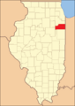
Kankakee County when it was first created in 1853.

Geography of Kankakee County
Kankakee County covers a total area of about 681 square miles. Most of this area, about 677 square miles, is land. The remaining 4.8 square miles is water.
Climate and Weather in Kankakee County
| Weather chart for Kankakee, Illinois | |||||||||||||||||||||||||||||||||||||||||||||||
|---|---|---|---|---|---|---|---|---|---|---|---|---|---|---|---|---|---|---|---|---|---|---|---|---|---|---|---|---|---|---|---|---|---|---|---|---|---|---|---|---|---|---|---|---|---|---|---|
| J | F | M | A | M | J | J | A | S | O | N | D | ||||||||||||||||||||||||||||||||||||
|
1.8
31
12
|
1.6
37
17
|
2.8
48
28
|
3.8
61
38
|
4.5
73
49
|
4.4
83
59
|
4.4
86
63
|
3.1
84
61
|
3.5
78
52
|
2.7
65
40
|
3.4
50
30
|
2.6
36
19
|
||||||||||||||||||||||||||||||||||||
| temperatures in °F precipitation totals in inches source: The Weather Channel |
|||||||||||||||||||||||||||||||||||||||||||||||
|
Metric conversion
|
|||||||||||||||||||||||||||||||||||||||||||||||
In the main city of Kankakee, temperatures usually range from 12°F (about -11°C) in January to 86°F (about 30°C) in July. However, the weather can be extreme. The coldest temperature ever recorded was -29°F (about -34°C) in January 1985. The hottest was 107°F (about 42°C) in August 1988. The county usually gets the most rain in May.
Neighboring Counties
Kankakee County shares its borders with several other counties:
- Will County – to the north
- Lake County, Indiana – to the northeast
- Newton County, Indiana – to the east
- Iroquois County – to the south
- Ford County – to the southwest
- Livingston County – to the west
- Grundy County – to the northwest
Population and People
| Historical population | |||
|---|---|---|---|
| Census | Pop. | %± | |
| 1860 | 15,412 | — | |
| 1870 | 24,352 | 58.0% | |
| 1880 | 25,047 | 2.9% | |
| 1890 | 28,732 | 14.7% | |
| 1900 | 37,154 | 29.3% | |
| 1910 | 40,752 | 9.7% | |
| 1920 | 44,920 | 10.2% | |
| 1930 | 50,095 | 11.5% | |
| 1940 | 60,877 | 21.5% | |
| 1950 | 73,524 | 20.8% | |
| 1960 | 92,063 | 25.2% | |
| 1970 | 97,250 | 5.6% | |
| 1980 | 102,926 | 5.8% | |
| 1990 | 96,255 | −6.5% | |
| 2000 | 103,833 | 7.9% | |
| 2010 | 113,449 | 9.3% | |
| 2020 | 107,502 | −5.2% | |
| 2023 (est.) | 105,940 | −6.6% | |
| U.S. Decennial Census 1790-1960 1900-1990 1990-2000 2010 |
|||

In 2010, there were about 113,449 people living in Kankakee County. These people lived in over 41,500 households. A household means all the people living in one home. About 35% of these households had children under 18.
The people in Kankakee County come from many different backgrounds. Many residents have roots in countries like Germany, Ireland, England, Italy, and Poland. About 9% of the population is of Hispanic or Latino origin. The average age of people in the county was about 36.7 years old.
Communities in Kankakee County
Cities
Villages
- Aroma Park
- Bonfield
- Bourbonnais
- Bradley
- Buckingham
- Chebanse
- Essex
- Grant Park
- Herscher
- Hopkins Park
- Irwin
- Limestone
- Manteno
- Reddick
- Sammons Point
- St. Anne
- Sun River Terrace
- Union Hill
Unincorporated Communities
- Ahern
- Altorf
- Deselm
- Dickeys
- Exline
- Garden of Eden
- Goodrich
- Greenwich
- Illiana Heights
- Illinoi (partial)
- Indian Oaks
- Leesville
- Lehigh
- Log Cabin Camp
- Saint George
- Sherburnville
- Sollitt
- Sugar Island
- Whitaker
- Wichert
Townships
Kankakee County is divided into seventeen smaller government areas called townships:
- Aroma
- Bourbonnais
- Essex
- Ganeer
- Kankakee
- Limestone
- Manteno
- Momence
- Norton
- Otto
- Pembroke
- Pilot
- Rockville
- St. Anne
- Salina
- Sumner
- Yellowhead
Education in Kankakee County
Kankakee County is home to two important schools for higher education. These are Olivet Nazarene University and Kankakee Community College.
Transportation in Kankakee County
Kankakee County has its own airport, called the Greater Kankakee Airport. For train travel, Amtrak provides service through the city of Kankakee. You can catch the Illini and Saluki trains, which go to Carbondale. The famous City of New Orleans train also stops here.
Within the city of Kankakee, people can use local buses run by the River Valley Metro Mass Transit District. For those living in Momence and other rural parts of Kankakee County, there is a bus service called SHOW Bus.
Major Highways
Several important highways pass through Kankakee County, making it easy to travel to and from the area:
 Interstate 57
 U.S. Highway 45
 U.S. Highway 52
 Illinois Route 1
 Illinois Route 17
 Illinois Route 50
 Illinois Route 102
 Illinois Route 113
 Illinois Route 114
 Illinois Route 115
See also
 In Spanish: Condado de Kankakee para niños
