Newton County, Indiana facts for kids
Quick facts for kids
Newton County, Indiana
|
|
|---|---|
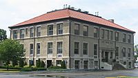
Newton County Courthouse in Kentland
|
|
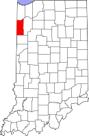
Location in the state of Indiana
|
|
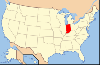
Indiana's location in the U.S.
|
|
| Country | |
| State | |
| Organized | February 7, 1835 |
| Abolished | 1839 |
| Re-organized | December 8, 1859 |
| Named for | Sgt. John Newton |
| County seat | Kentland |
| Largest town | Kentland (population and total area) |
| Incorporated Municipalities |
|
| Government | |
| • Type | County |
| • Body | Board of Commissioners |
| Area | |
| • County | 403.44 sq mi (1,044.9 km2) |
| • Land | 401.76 sq mi (1,040.6 km2) |
| • Water | 1.68 sq mi (4.4 km2) |
| • Metro | 10,874 sq mi (28,160 km2) |
| Area rank | 43rd largest county in Indiana |
| • Region | 2,726 sq mi (7,060 km2) |
| Elevation | 692 ft (211 m) |
| Population
(2020)
|
|
| • County | 13,830 |
| • Estimate
(2023)
|
13,960 |
| • Rank | 82nd largest county in Indiana |
| • Density | 34.280/sq mi (13.236/km2) |
| • Region | 819,537 |
| Time zone | UTC−6 (Central) |
| • Summer (DST) | UTC−5 (Central) |
| ZIP Codes |
46310, 46349, 46381, 47922, 47942-43, 47948, 47951, 47963, 47978
|
| Area code | 219 |
| Congressional district | 4th |
| Indiana Senate district | 6th |
| Indiana House of Representatives districts | 15th and 19th |
| FIPS code | 18-111 |
| GNIS feature ID | 0450376 |
| Interstate and U.S. Routes | |
| State Routes | |
| Airport | Kentland Municipal
|
| Waterways | Iroquois River – Kankakee River |
| Website | www.newtoncounty.in.gov |
|
|
| Demographic | Proportion |
|---|---|
| White | 96.2% |
| Black | 0.4% |
| Asian | 0.3% |
| Islander | 0.0% |
| Native | 0.3% |
| Other | 2.8% |
| Hispanic (any race) |
5.0% |
Newton County is a place in the northwest part of Indiana, a state in the United States. In 2020, about 13,830 people lived here. It's part of an area called Northwest Indiana and is also close to the big city of Chicago. The main town, or county seat, is Kentland. Newton County has 10 smaller areas called townships that help with local services.
Contents
History of Newton County
The first Newton County was created on February 7, 1835. It was a large square area. This area included the northern parts of what are now Newton and Jasper County.
In 1836, the northern border moved to the Kankakee River. Land north of the river went to Lake and Porter counties. In 1839, the county was closed and joined with Jasper County.
On December 8, 1859, Newton County was created again. Its borders were set to mostly what they are today. Newton County was the last of Indiana's 92 counties to be officially formed.
How Newton County Got Its Name
Newton County is named after Sergeant John Newton. He was a soldier in the American Revolutionary War. He served under General Francis Marion, known as the "Swamp Fox."
It is next to Jasper County. Jasper County is named after Sergeant William Jasper, another brave soldier. It's interesting that several other states, like Georgia, Mississippi, Missouri, and Texas, also have neighboring Jasper and Newton counties. It seems these two soldiers were often remembered together!
Geography of Newton County
Newton County covers about 403 square miles. Most of this area, about 401 square miles, is land. The rest, about 1.68 square miles, is water.
A long time ago, Beaver Lake was in Newton County. It was Indiana's largest lake, but it was later drained. Today, J.C. Murphy Lake is found in the Willow Slough Fish and Wildlife Area.
Newton County is also home to the Kentland crater. This is a place where a meteorite likely hit the Earth. It is located between the towns of Kentland and Goodland.
Major Roads and Highways
Many important roads pass through Newton County. These roads help people travel and transport goods.
- Interstate 65
- U.S. Route 24
- U.S. Route 41
- U.S. Route 52
- State Road 10
- State Road 14
- State Road 16
- State Road 55
- State Road 71
- State Road 114
Railroads in the County
Trains also play a role in transportation in Newton County.
- CSX Transportation
- Toledo, Peoria and Western Railway
Neighboring Counties
Newton County shares its borders with several other counties:
- To the north: Lake County
- To the east: Jasper County
- To the south and eastern border: Benton County
- To the west: Iroquois County, Illinois
- To the northwest: Kankakee County, Illinois
Towns and Communities
Newton County has several towns and smaller communities. Here are the populations from the 2010 Census.
Towns in Newton County
Other Communities
Some areas are called "census-designated places." This means they are like towns but not officially incorporated.
- Lake Village – 765 people
- Roselawn – 4,131 people
There are also many other small, unincorporated communities in the county:
- Ade
- Beaver City
- Conrad
- Effner
- Enos
- Foresman
- Newton
- Pembroke
- Perkins
- Sumava Resorts
- Thayer
Townships of Newton County
Newton County is divided into 10 smaller areas called townships. These townships help manage local services. Here are their names:
- Beaver
- Colfax
- Grant
- Iroquois
- Jackson
- Jefferson
- Lake
- Lincoln
- McClellan
- Washington
Climate and Weather
| Weather chart for Kentland, Indiana | |||||||||||||||||||||||||||||||||||||||||||||||
|---|---|---|---|---|---|---|---|---|---|---|---|---|---|---|---|---|---|---|---|---|---|---|---|---|---|---|---|---|---|---|---|---|---|---|---|---|---|---|---|---|---|---|---|---|---|---|---|
| J | F | M | A | M | J | J | A | S | O | N | D | ||||||||||||||||||||||||||||||||||||
|
1.8
31
14
|
1.6
36
18
|
2.8
48
29
|
3.4
61
38
|
4.1
73
50
|
4.5
82
60
|
4
85
63
|
3.7
83
60
|
3.3
78
53
|
2.8
65
41
|
3.2
49
31
|
2.4
36
20
|
||||||||||||||||||||||||||||||||||||
| temperatures in °F precipitation totals in inches source: The Weather Channel |
|||||||||||||||||||||||||||||||||||||||||||||||
|
Metric conversion
|
|||||||||||||||||||||||||||||||||||||||||||||||
The weather in Kentland, the county seat, changes throughout the year. In January, the average low temperature is about 14°F (minus 10°C). In July, the average high temperature is about 85°F (29°C).
The coldest temperature ever recorded was minus 25°F (minus 32°C) in January 1985. The hottest was 104°F (40°C) in June 1988. The amount of rain and snow changes too. February usually has the least, about 1.60 inches (4 cm). June has the most, about 4.51 inches (11.5 cm).
Population and People
| Historical population | |||
|---|---|---|---|
| Census | Pop. | %± | |
| 1860 | 2,360 | — | |
| 1870 | 5,829 | 147.0% | |
| 1880 | 8,167 | 40.1% | |
| 1890 | 8,803 | 7.8% | |
| 1900 | 10,448 | 18.7% | |
| 1910 | 10,504 | 0.5% | |
| 1920 | 10,144 | −3.4% | |
| 1930 | 9,841 | −3.0% | |
| 1940 | 10,775 | 9.5% | |
| 1950 | 11,006 | 2.1% | |
| 1960 | 11,502 | 4.5% | |
| 1970 | 11,606 | 0.9% | |
| 1980 | 14,844 | 27.9% | |
| 1990 | 13,551 | −8.7% | |
| 2000 | 14,566 | 7.5% | |
| 2010 | 14,244 | −2.2% | |
| 2020 | 13,830 | −2.9% | |
| 2023 (est.) | 13,960 | −2.0% | |
| U.S. Decennial Census 1790-1960 1900-1990 1990-2000 2010 |
|||
In 2010, there were 14,244 people living in Newton County. There were 5,503 households, which are groups of people living together. About 3,945 of these were families.
Most people in the county were white (96.2%). About 5.0% of the population was of Hispanic or Latino origin. Many people had German (30.4%), Irish (16.9%), or English (11.0%) backgrounds.
About 31.1% of households had children under 18. The average age of people in the county was 42.4 years old. The average income for a household was $47,697. About 8.2% of the population lived below the poverty line.
Education in Newton County
Newton County has public schools managed by two different school districts. These districts make sure students get a good education.
School Districts
- North Newton School Corporation
- South Newton School Corporation
High Schools and Middle Schools
- North Newton Junior-Senior High School
- South Newton High School
- South Newton Middle School
Elementary Schools
- Lake Village Elementary School
- Lincoln Elementary School
- Morocco Elementary School
- South Newton Elementary School
See also
 In Spanish: Condado de Newton (Indiana) para niños
 | William Lucy |
 | Charles Hayes |
 | Cleveland Robinson |


