
Iroquois River (Indiana-Illinois) facts for kids
Quick facts for kids Iroquois River |
|
|---|---|

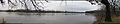
The Iroquois River in Newton County, Indiana.
|
|
| Country | United States |
| Physical characteristics | |
| Main source | NW of Rensselaer, Newton Township, Jasper County, Indiana 705 feet (215 m) 40°57′55″N 87°12′23″W / 40.9652778°N 87.2063889°W |
| River mouth | Kankakee, Illinois 599 feet (183 m) 41°04′27″N 87°48′59″W / 41.0741993°N 87.8164285°W |
| Length | 103 miles (166 km) |
| Basin features | |
| Progression | Iroquois River → Kankakee → Illinois → Mississippi → Gulf of Mexico |
| Basin size | 2,091 sq mi (5,420 km2) |
| GNIS ID | 410927 |
The Iroquois River is a river about 103 miles (166 km) long. It flows through northwestern Indiana and northeastern Illinois in the United States. This river is a tributary of the Kankakee River. It was named after the Iroquois people. The Iroquois River is part of the larger watershed of the Mississippi River. This means its water eventually flows into the Mississippi River.
Contents
Where the River Flows
The Iroquois River starts in Jasper County, Indiana. It then flows mostly southwest through Newton County, Indiana, and Iroquois County, Illinois. In Iroquois County, it turns north. Finally, it flows into Kankakee County, Illinois. The river joins the Kankakee River from the south near the village of Aroma Park. This spot is about 4 miles (6 km) southwest of the city of Kankakee.
Along its journey, the Iroquois River passes several towns. In Indiana, it flows near Rensselaer, Brook, and Kentland. In Illinois, it goes by Iroquois, Watseka, and Sugar Island.
How the River Got Its Name
The French explorers called this river La rivière des Iroquois. This name means "the river of the Iroquois." It is believed the name came from "la Fourche des Iroquois," or "the Fork of the Iroquois." This fork is now Aroma Park. The name likely refers to a place where the French or their allies had an encounter with the Iroquois people.
French explorers, like René-Robert Cavelier, Sieur de La Salle, arrived in the Kankakee area in 1679. The Iroquois people had been moving west, raiding across the Michigan Peninsula. In 1682, La Salle built Fort St. Louis at Starved Rock State Park on the Illinois River. This fort was a safe place from Iroquois raids. The history of these raids, known as the Beaver Wars, suggests that Iroquois groups used the Iroquois River route. They likely used it to get around the large marshy areas of the Kankakee.
An old story from the Illinois people tells of a time when the Iroquois were surprised along this waterway. They were driven away with many losses. This story was also heard by Colonel Gurdon Saltonstall Hubbard in the mid-1800s.
River's Surroundings
The Iroquois River gets its water from several smaller streams. These include Sugar, Mud, Fountain Spring, Prairie, Langham, Pike, and Beaver creeks. From Sugar Island (around Iroquois County Rd 3300 N) to its mouth at Aroma Park, the river is shallow and has many rocks. It is surrounded by silurian limestone. South of Sugar Island, the river becomes deep and slow-moving, almost to the state line.
The Iroquois River starts in low-lying areas northwest of Rensselaer, Indiana. It flows in a clockwise direction to the north and east, entering Rensselaer from the east. It then continues southwest for over 30 miles (48 km) to Watseka, Illinois. From Watseka, the river turns north. It flows another 30 miles (48 km) to meet the Kankakee.
Towns and Cities Along the River
- Rensselaer, Indiana
- Brook, Indiana
- Kentland, Indiana
- Iroquois, Illinois
- Watseka, Illinois
- Sugar Island, Illinois
Images for kids
-
Junction of the Iroquois River (left) with the Kankakee River at Aroma Park, Illinois
-
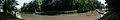
Junction of the Iroquois River (left) with the Newton County Fair grounds in Kentland, Indiana By Andrew Spiker
