
Porter County, Indiana facts for kids
Quick facts for kids
Porter County
|
||
|---|---|---|

Porter County Courthouse in Valparaiso
|
||
|
||
| Motto(s):
"Front Porch of the Dunes"
|
||

Location in the state of Indiana
|
||

Indiana's location in the U.S.
|
||
| Country | ||
| State | ||
| Region | Northwest Indiana | |
| Metro area | Chicago Metropolitan | |
| Established | 1836 | |
| Named for | David Porter | |
| County seat | Valparaiso | |
| Largest city | Portage (population and area) | |
| Incorporated municipalities |
11 cities and towns
Beverly Shores (town)
Burns Harbor (town) Chesterton (town) Dune Acres (town) Hebron (town) Kouts (town) Ogden Dunes (town) Portage (city) Porter (town) Town of Pines (town) Valparaiso (city) |
|
| Government | ||
| • Type | County | |
| Area | ||
| • County | 521.8 sq mi (1,351 km2) | |
| • Land | 418.2 sq mi (1,083 km2) | |
| • Water | 103.6 sq mi (268 km2) | |
| • Metro | 10,874 sq mi (28,160 km2) | |
| Area rank | 29th largest county in Indiana | |
| • Region | 2,726 sq mi (7,060 km2) | |
| Elevation
(mean)
|
843 ft (257 m) | |
| Highest elevation
– NE Jackson Twp
|
870 ft (270 m) | |
| Lowest elevation
– at Lake Michigan
|
585 ft (178 m) | |
| Population
(2020)
|
||
| • County | 173,215 | |
| • Estimate
(2023)
|
173,335 |
|
| • Rank | 9th largest county in Indiana 374th largest county in U.S. |
|
| • Density | 331.96/sq mi (128.169/km2) | |
| • Metro | 9,522,434 | |
| • Region | 819,537 | |
| Time zone | UTC−6 (Central) | |
| • Summer (DST) | UTC−5 (Central) | |
| ZIP Codes |
46301-02, 46304, 46307-08, 46341-42, 46347, 46360, 46368, 46383-85, 46391, 46393
|
|
| Area code | 219 | |
| Congressional district | 1st | |
| Indiana Senate districts | 4th, 5th and 6th | |
| Indiana House of Representatives districts | 3rd, 4th, 10th, 19th and 20th | |
| FIPS code | 18-127 | |
| GNIS feature ID | 0450382 | |
| Interstates | ||
| U.S. Routes | ||
| State Routes | ||
| Airport | Porter County Regional
|
|
| Waterways | East Arm Little Calumet River Kankakee River Lake Michigan Little Calumet River Port of Indiana-Burns Harbor Salt Creek |
|
| South Shore Line stations | Beverly Shores – Dune Park Portage/Ogden Dunes
|
|
| Public transit | V-Line | |
| Website | www.porterco.org | |
|
||

Porter County is a county located in the state of Indiana in the U.S.. In 2020, about 173,215 people lived here, making it the 10th most populated county in Indiana. The main city and county seat is Valparaiso.
Porter County is part of Northwest Indiana and also the larger Chicago metropolitan area. A big part of the Indiana Dunes, which is a special natural area, is found in Porter County. The Hour Glass Museum in Ogden Dunes helps tell the story of this important natural region.
Contents
History of Porter County
The area that is now Porter County was first home to a group of Native Americans called Huber-Berrien. They lived here after the glaciers melted thousands of years ago. Later, during the Iroquois Wars (1641–1701), the Potawatomi and Miami tribes lived in this region.
Early maps from the 1830s show two Native American towns: Chiqua's town and Tassinong. Chiqua's town was near Valparaiso, and Tassinong was south of Valparaiso. These were important stops along old trails.
After the American Revolutionary War, the U.S. government created the Northwest Territory in 1787, which included Indiana. In 1800, this area became the Indiana Territory. Indiana officially became a state in December 1816.
Porter County was created by the Indiana State Legislature on February 7, 1835. It was officially organized in 1837. The county was named after Captain David Porter, a naval officer who served in the Barbary Wars and the War of 1812.
In 1962, a large steel mill was built on the shores of Lake Michigan. This project, along with the nearby Port of Indiana, caused a lot of debate. Many local people wanted to protect the natural shoreline and wildlife. Even though the steel mill and port were built, the U.S. Congress created the Indiana Dunes National Lakeshore in 1966. This was done to protect the unique natural areas that remained.
Geography and Nature
Porter County is located in the northern part of Indiana. Its northern border is Lake Michigan, and its southern border is the Kankakee River. Most of the county's land, which used to have many trees, is now used for farming.
The East Arm Little Calumet River flows through the northern part of the county. The highest point in Porter County is a small hill on its eastern border, about 870 feet (265 meters) high. The lowest point is along the Lake Michigan shoreline, at about 585 feet (178 meters).
Porter County covers about 521.78 square miles (1,351.4 square kilometers). Most of this is land, but about 103.63 square miles (268.4 square kilometers) is water, mainly from Lake Michigan.
Neighboring Counties
- LaPorte County (east)
- Starke County (southeast)
- Jasper County (south)
- Lake County (west)
- Cook County, Illinois (northwest, across Lake Michigan)
- Berrien County, Michigan (northeast, across Lake Michigan)
Protected Natural Areas
Porter County is home to several important natural areas:
- Indiana Dunes National Park (part of it)
- Indiana Dunes National Park Heron Rookery
- Indiana Dunes State Park
- Moraine Nature Preserve
Major Roads and Transportation
Porter County has many important roads that help people travel around. These include major Interstates and U.S. Routes.
 Interstate 80
 Indiana Toll Road
 Interstate 94
 U.S. Route 6
 U.S. Route 12
 U.S. Route 20
 U.S. Route 30
 U.S. Route 231
 State Road 2
 State Road 8
 State Road 49
 State Road 130
 State Road 149
 State Road 249
 State Road 520

Railroads
Several railroad companies operate in Porter County, including:
- Amtrak
- Canadian National
- Chesapeake and Indiana Railroad
- Chicago, Fort Wayne and Eastern Railroad
- Chicago South Shore and South Bend Railroad
- CSX Transportation
- Norfolk Southern Railway
- South Shore Line
Cities and Towns
Porter County has several cities and towns, each with its own unique community. Here are the main ones and their populations from the 2010 Census:
Cities
- Portage – 36,828 people
- Valparaiso – 31,730 people
Towns
- Beverly Shores – 613 people
- Burns Harbor – 1,156 people
- Chesterton – 13,068 people
- Dune Acres – 182 people
- Hebron – 3,724 people
- Kouts – 1,879 people
- Ogden Dunes – 1,110 people
- Porter – 4,858 people
- Town of Pines – 708 people
.jpg)

Unincorporated Communities
These are smaller communities that are not officially cities or towns, but still have residents:
- Aylesworth
- Babcock
- Boone Grove
- Burdick
- Crocker
- Furnessville
- Malden
- Suman
- Tassinong
- Woodville
Townships
Porter County is divided into 12 townships, which are local government areas:
- Boone
- Center
- Jackson
- Liberty
- Morgan
- Pine
- Pleasant
- Portage
- Porter
- Union
- Washington
- Westchester
Education in Porter County
Porter County offers many educational opportunities, from colleges to public schools.
.jpg)
Colleges and Universities
- Ivy Tech Community College
- Valparaiso University
Public School Districts
Public schools in Porter County are managed by several different school districts:
- Metropolitan School District of Boone Township (for Boone Township)
- Duneland School Corporation (for Jackson, Liberty, and Westchester townships)
- East Porter County School Corporation (for Morgan, Pleasant, and Washington townships)
- Michigan City Area Schools (for Pine Township)
- Portage Township Schools (for Portage Township)
- Porter Township School Corporation (for Porter Township)
- Union Township School Corporation (for Union Township)
- Valparaiso Community Schools (for Center Township)
High Schools and Middle Schools
- Benjamin Franklin Middle School
- Boone Grove High School
- Boone Grove Middle School
- Chesterton High School
- Chesterton Middle School
- Hebron High School
- Hebron Middle School
- Kouts Middle-High School
- Morgan Township Middle/High School
- Portage High School
- Thomas Jefferson Middle School
- Union Township Middle School
- Valparaiso High School
- Washington Township Middle/High School
- Wheeler High School
- William Fegely Middle School
- Willowcreek Middle School
Elementary Schools
- Aylesworth Elementary School
- Bailly Elementary School
- Boone Grove Elementary School
- Brummitt Elementary School
- Central Elementary School (Portage)
- Central Elementary School (Valparaiso)
- Cooks Corners Elementary School
- Crisman Elementary School
- Flint Lake Elementary School
- Hayes Leonard Elementary School
- Hebron Elementary School
- Jackson Elementary School
- John Simatovich Elementary School
- Jones Elementary School
- Kouts Elementary School
- Kyle Elementary School
- Liberty Elementary School
- Liberty Intermediate School
- Memorial Elementary School
- Morgan Elementary School
- Myers Elementary School
- Northview Elementary School
- Parkview Elementary School
- Paul Saylor Elementary School
- Pine Elementary School
- Porter Lakes Elementary School
- South Haven Elementary School
- Thomas Jefferson Elementary School
- Union Center Elementary School
- Washington Township Elementary School
- Westchester Intermediate School
- Yost Elementary School
Public Libraries
Porter County has two public library systems that serve its communities:
- Porter County Public Library: Its main branch is in Valparaiso, with other branches in Hebron, Kouts, Portage, and South Haven.
- Westchester Public Library: Its main branch, the Thomas Library, is in Chesterton. It also has a branch called the Hageman Library in Porter.
Hospitals
- Porter Health Care System: This system includes two hospitals.
- Portage Hospital in Portage
- Porter Regional Hospital in Valparaiso
Climate and Weather
The weather in Valparaiso, Porter County, changes throughout the year.
- In January, the average low temperature is about 15°F (-9°C).
- In July, the average high temperature is about 83°F (28°C).
- The lowest temperature ever recorded was -25°F (-32°C) in January 1985.
- The highest temperature ever recorded was 105°F (41°C) in July 1934.
- The amount of rain and snow changes too. February usually has the least precipitation, while June has the most.
Population and People
As of the 2020 Census, Porter County had a population of 173,215 people. The county has grown steadily over the years.
In 2010, there were 164,343 people living in the county. Most residents were white (91.3%), with other groups including black or African American (3.0%), Asian (1.2%), and American Indian (0.3%). About 8.5% of the population was of Hispanic or Latino origin.
The average household size was about 2.6 people. The median age in the county was 38.4 years old. This means half the people were younger than 38.4, and half were older.
The median income for a household in the county was $47,697 in 2010. For families, the median income was $73,065. About 9.4% of the population lived below the poverty line.
Parks and Recreation
Porter County has several parks where people can enjoy nature and outdoor activities.
- Brincka Cross Gardens is a 4-acre (1.6 ha) garden in Pine Township.
- Calumet Trail is a 9.1-mile (14.6 km) long trail near U.S. 12. It's great for walking, running, biking, and cross-country skiing.
- Dunn's Bridge County Park is on the southern edge of the county. It has an old bridge over the Kankakee River and offers access for small boats.
- Sunset Hill Farm County Park is a large 238-acre (96 ha) park. It has open meadows used for festivals and events.
Cultural Activities
Porter County offers many fun and interesting cultural activities, including museums and live theater.
Museums
- Alton Goin Museum in Portage tells the history of the city.
- Bailly Homestead & Chellberg Farm are part of Indiana Dunes National Park, showing early life in the area.
- Brauer Museum of Art at Valparaiso University has a large collection of art.
- Depot of Beverly Shores Museum & Art Gallery shows the history of Beverly Shores and features local art.
- Hour Glass House Museum displays art from local artists.
- Porter County Museum of History preserves the history of Porter County.
- Stagecoach Inn & Panhandle Depot in Hebron is run by the Hebron Historical Society.
- Westchester Township History Museum is in the George Brown Mansion and shows local history of the Indiana Dunes.
- Task Force Tips Fire Museum in Valparaiso displays the history of fire equipment.
Live Theater
- 4th Street Theater is a community theater in Chesterton.
- Chicago Street Theatre is a community theater in Valparaiso.
- Front Porch Music in Valparaiso hosts weekly "open mic" nights and concerts.
- Memorial Opera House presents live theater and other monthly shows.
- Valparaiso Theatrical Company performs plays at different places in Porter County to help charities.
- Valparaiso University Center for the Arts is where Valparaiso University holds its performing arts events.
Images for kids
-
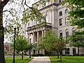
Porter County Courthouse in Valparaiso
-

Flag of Porter County, Indiana
-
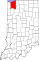
Map showing Porter County's location in Indiana
-
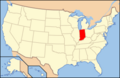
Map showing Indiana's location in the U.S.
-
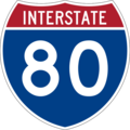
Interstate 80
-

Indiana Toll Road
-
Interstate 90
-
Interstate 94
-
U.S. Route 6
-
U.S. Route 12
-
U.S. Route 20
-
U.S. Route 30
-
U.S. Route 231
-
Indiana State Road 2
-
Indiana State Road 8
-
Indiana State Road 49
-
Indiana State Road 130
-
Indiana State Road 149
-
Indiana State Road 249
-
Indiana State Road 520


See also
 In Spanish: Condado de Porter para niños
