
Porter, Indiana facts for kids
Quick facts for kids
Porter, Indiana
|
|
|---|---|

Lincoln Street in Porter
|
|

Location of Porter in Porter County, Indiana.
|
|
| Country | United States |
| State | Indiana |
| County | Porter |
| Township | Westchester |
| Area | |
| • Total | 6.44 sq mi (16.69 km2) |
| • Land | 6.16 sq mi (15.96 km2) |
| • Water | 0.28 sq mi (0.74 km2) |
| Elevation | 659 ft (201 m) |
| Population
(2020)
|
|
| • Total | 5,210 |
| • Density | 845.64/sq mi (326.50/km2) |
| Time zone | UTC-6 (Central (CST)) |
| • Summer (DST) | UTC-5 (CDT) |
| ZIP code |
46304, 46369
|
| Area code(s) | 219 |
| FIPS code | 18-61164 |
| GNIS feature ID | 2396863 |
| Website | http://www.townofporter.com/ |
Porter is a town in Westchester Township, Porter County, in the U.S. state of Indiana. As of the 2020 census, about 5,210 people live here. Porter is part of the amazing Indiana Dunes area, which helped start important conservation efforts. It's also home to Porter Beach, sometimes called Johnson's Beach, right on Lake Michigan.
Porter is well-known for being very close to Indiana Dunes State Park. It also has a rich history with railroads. Long ago, Porter was the end of the line for the Chicago and West Michigan Railway.
History of Porter
The town of Porter began in the 1850s. This was when the railroad lines were built and extended to this area, helping the town grow.
Exploring Historic Sites in Porter
Porter is home to several interesting historic places that tell stories of the past.
Joseph Bailly Homestead: A Fur Trader's Home
The Joseph Bailly Homestead is located inside Indiana Dunes National Park. You can find it on Howe Road, just north of U.S. 20. This special place was home to three generations of the Bailly family. Joseph and Marie Bailly first arrived here in 1822. Joseph had been a fur trader on Lake Michigan for almost 30 years before he built his family home along the Little Calumet River.
Chellberg Farm: A Swedish Family's Legacy
The Chellberg Farm is another historic home that belonged to three generations of a family. The Anders Kjellburg (Chellberg) family came to this Swedish community in 1869. They bought 80 acres of land from the Bailly family's descendants. The farm is located on Mineral Springs Road, north of U.S. 20.
Augsburg Swedish Lutheran Church and Cemetery
The Augsburg Swedish Lutheran Church and its cemetery are located on Beam Street, west of town. The cemetery was started in 1878.
Other Important Historic Places
Besides the Joseph Bailly Homestead, two other places in Porter are listed on the National Register of Historic Places. These are the Good Fellow Club Youth Camp and the Porter Town Hall.
Geography of Porter
Porter covers a total area of about 6.48 square miles (16.78 square kilometers). Most of this area, about 6.2 square miles (16.06 square kilometers), is land. The rest, about 0.28 square miles (0.72 square kilometers), is water.
Population of Porter
| Historical population | |||
|---|---|---|---|
| Census | Pop. | %± | |
| 1880 | 224 | — | |
| 1910 | 524 | — | |
| 1920 | 699 | 33.4% | |
| 1930 | 805 | 15.2% | |
| 1940 | 1,190 | 47.8% | |
| 1950 | 1,458 | 22.5% | |
| 1960 | 2,189 | 50.1% | |
| 1970 | 3,058 | 39.7% | |
| 1980 | 2,988 | −2.3% | |
| 1990 | 3,118 | 4.4% | |
| 2000 | 4,972 | 59.5% | |
| 2010 | 4,858 | −2.3% | |
| 2020 | 5,210 | 7.2% | |
| Source: US Census Bureau | |||
Porter's Population in 2010
In 2010, there were 4,858 people living in Porter. These people lived in 1,832 households, and 1,310 of these were families. The town had about 783.5 people per square mile.
Most of the people in Porter were White (94.3%). There were also smaller groups of African American (1.1%), Native American (0.3%), and Asian (0.9%) residents. About 6.6% of the population identified as Hispanic or Latino.
In terms of age, the average age in Porter was 39.1 years old. About 25.6% of residents were under 18 years old.
Images for kids
-
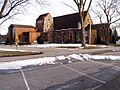
Augsburg Lutheran Church

See also
 In Spanish: Porter (Indiana) para niños
