Tassinong, Indiana facts for kids
Quick facts for kids
Tassinong, Indiana
|
|
|---|---|

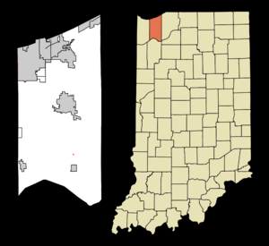
Map of Porter County, Indiana with an inset showing the location of the community of Tassinong
|
|
| Country | United States |
| State | Indiana |
| County | Porter |
| Township | Morgan |
| Area | |
| • Total | 0.1 sq mi (0.026 km2) |
| • Land | 0.1 sq mi (0.026 km2) |
| • Water | 0.0 sq mi (0.0 km2) |
| Elevation | 695 ft (211.8 m) |
| Population
(2010)
|
|
| • Total | 15 |
| Time zone | UTC-6 (CST) |
| • Summer (DST) | UTC-5 (CDT) |
| ZIP code |
46302
|
| Area code(s) | 219 |
Tassinong is a small community in Porter County, Indiana. It's located in the countryside, south of the city of Valparaiso. There's a special marker in Tassinong. It says that the area was a French mission and trading post way back in 1673! If that's true, it would be the oldest European settlement in both Indiana and nearby Illinois.
Contents
Exploring Tassinong's Past
The name Tassinong first appeared in 1830. It was used to describe a village where Potawatomi Native Americans lived. The historic marker in Tassinong tells us about an old Native American village and a French trading post that were once here.
The first Europeans in the Porter County area arrived in 1679. This was when Sieur de La Salle traveled down the Kankakee River. This river is about 7 miles (11 km) south of Tassinong. At that time, the area south of Lake Michigan was caught up in the Beaver Wars. These wars started in 1638 in the lands of the Iroquois people in New York.
The Iroquois were very powerful. They had defeated the Erie Nation by 1656. By 1670, they had moved west into the western Great Lakes region.
Battles and New Settlements
In 1689, the Miami people, with help from the Anishinaabe Confederacy, fought back. The Anishinaabe Confederacy included the Odawa, Potawatomi, and Ojibwa tribes. They defeated the Iroquois near what is now South Bend.
This victory led to the Potawatomi people moving back to the lands around the St. Joseph River. By 1695, over 200 warriors and their families had come to the St. Joseph valley.
A new settlement was officially started in 1834. This was four years after the Potawatomi village was first mentioned. The village might have gotten its name from the nearby woods, called Tassinong Grove.
Growth and Change
A post office opened at Tassinong Grove on April 10, 1838. Tassinong Grove was located about 2 miles (3.2 km) south of the current Tassinong community.
By 1846, the community and its post office had moved north. They settled where Baum’s Bridge Road met the road to Valparaiso. This is now Indiana State Road 49. In that year, Tassinong had several businesses. There were two stores, two blacksmiths, a carpenter, a tavern, and a shoemaker. A church was built in 1855 by the Presbyterians.
The village started to decline in 1865. This happened when the Pittsburgh, Cincinnati and St. Louis Railroad was built through Kouts. Kouts is about 2 miles (3.2 km) south of Tassinong. The railroad made Kouts a more important center.
Where is Tassinong Located?
Tassinong first appeared on a map in 1875. This was when the state of Indiana finished surveying Morgan and Pleasant townships in Porter County.
The map showed a trail leading from a place called Potawatomi Ford. This was near what is now Baum’s Bridge. The trail followed Baum’s Bridge Road to the Tassinong area. From there, it headed north towards Valparaiso. The oldest available map of Porter County, from 1876, shows Tassinong village in a specific part of Section 31, Township 34, Range 5.
Schools in the Area
Tassinong is part of the East Porter County School Corporation. Students in Tassinong attend Morgan Township High School. This school is located north of Malden on State Route 49.
Getting Around Tassinong
State Route 49 is an important road for Tassinong. It goes north past Valparaiso and ends at the Indiana Dunes State Park on Lake Michigan. To the south, it connects to State Route 14 in central Jasper County.
 | Janet Taylor Pickett |
 | Synthia Saint James |
 | Howardena Pindell |
 | Faith Ringgold |


