Kentland crater facts for kids
The Kentland structure is a special place in Kentland, Indiana, where a giant space rock crashed long ago. It's also known as the Kentland crater or the Kentland disturbed area. This amazing site is in Newton County, Indiana, in the United States.
Farmers first found this unusual area around 1880 while digging for rocks. Scientists later studied the site and saw strange rock formations called shatter cones. These special rocks, along with bent and twisted bedrock, showed that a huge space rock had hit the area. This proved it was an impact structure, not a volcano. The rocks were pushed and bent in incredible ways, with layers that are usually flat now standing on end.
The main part of the structure is a round, dome-shaped area. It's about 7.24 kilometers (4.5 miles) wide. Over millions of years, much of the original crater has worn away. It's also covered by dirt and rocks left behind by ancient glaciers. Scientists think the impact happened less than 97 million years ago, during the Cretaceous Period. Some rocks at the center are much older, about 450 million years old. These ancient rocks were pushed up about 610 meters (2,000 feet) higher than usual by the impact! The entire disturbed area stretches about 13 kilometers (8 miles) wide.
Scientists are still discussing the exact age of the impact. Some believe it happened about 97 million years ago. Others think it might be around 300 million years old.
In 1978, scientists like John Weber studied the Kentland structure closely. They found special minerals like coesite and more shatter cones near the center. These are strong signs of a powerful impact. Because the impact site is at the surface, it has slowly worn away over time. Today, the area is still used as a quarry, where people dig for rocks.
What is the Kentland Structure?
The Kentland impact site is located about 4 kilometers (2.5 miles) east of Kentland, Indiana. The disturbed area is about 12.5 kilometers (7.8 miles) across. The bedrock here has a thin layer of dirt and rocks from glaciers, up to 40 meters (130 feet) deep in some low spots.
Normally, the bedrock around this part of Indiana is quite flat. It gently slopes towards the Illinois Basin. The upper rock layers, from the Lower Mississippian and Upper Devonian periods, are usually flat. But at the Kentland site, they are completely mixed up!
At the very center of the site are very old rocks from the Ordovician period. Around this center are rocks from the Silurian period, like Sexton Creek Dolomite and Kokomo Limestone. These uplifted older rocks poke through younger layers. They even pierce through the New Albany Shale (from the Devonian age) and the New Providence Shale and Rockford Limestone (from the Mississippian age).
Before quarrying began, scientists estimated that about 300 meters (980 feet) of rock had worn away since the impact. Later, glaciers left a shallow layer of dirt. Since 1906, quarry operations have been digging out the upper Ordovician rocks along the northern edge of the site.
How the Structure Formed
The Kentland Structure is a deeply eroded complex crater. This means it was a very large impact crater that had a central peak or dome. Since the original impact, more than 300 meters (980 feet) of rock have worn away. This erosion has removed the original crater rim and other surface features.
A circular ring surrounds the main impact site. This ring separates the disturbed area from the flat rocks around it. The ring is about 6.2 kilometers (3.9 miles) from the center.
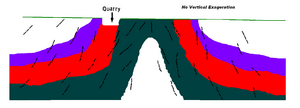
This ring depression formed because materials at lower levels moved to fill the space. This happened as the central dome of rock rose up after the impact. Studies at other similar impact sites show that this depression matches the amount of material that shifted under the rising center. The image above shows a cross-section of the uplift, from its outer edge towards the middle.
 | Anna J. Cooper |
 | Mary McLeod Bethune |
 | Lillie Mae Bradford |


