Benton County, Indiana facts for kids
Quick facts for kids
Benton County
|
||
|---|---|---|

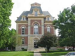
Benton County Courthouse in Fowler, Indiana.
|
||
|
||

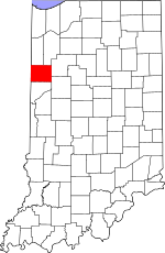
Location within the U.S. state of Indiana
|
||
 Indiana's location within the U.S. |
||
| Country | ||
| State | ||
| Founded | February 18, 1840 | |
| Named for | Senator Thomas H. Benton | |
| Seat | Fowler | |
| Largest city | Fowler | |
| Area | ||
| • Total | 406.51 sq mi (1,052.9 km2) | |
| • Land | 406.42 sq mi (1,052.6 km2) | |
| • Water | 0.09 sq mi (0.2 km2) 0.02%% | |
| Population
(2020)
|
||
| • Total | 8,719 | |
| • Density | 21.4484/sq mi (8.2813/km2) | |
| Time zone | UTC−5 (Eastern) | |
| • Summer (DST) | UTC−4 (EDT) | |
| Congressional district | 4th | |
|
||
Benton County is a cool place in northwest Indiana, right next to Illinois. In 2020, about 8,719 people lived here. It has six towns and many smaller communities. The county is split into 11 townships that help with local services. The main town, or county seat, is Fowler.
Benton County is also part of the bigger Lafayette area.
Contents
Benton County's Story: A Look Back
The land that is now northwest Indiana was first explored by a French explorer named Robert de LaSalle. At that time, different Native American groups lived here, including the Miami Confederation. Over time, as more settlers moved into the area, these groups gave up their land.
In 1818, the Pottawattamies, Weas, and Delawares gave up their lands west of the Tippecanoe River. Later, in 1826, the Pottawattamie and Miamis gave up more land. By 1832, the Pottawattamie had given up control of all their remaining land in Indiana and Michigan.
Before 1832, this area was not really open for new settlers. It was described as having swamps, sandy ridges, and wet prairies. However, it was full of wild animals for hunting.
How Benton County Was Formed
On February 7, 1835, the state created two new counties in this area: Newton and Jasper. At first, these counties were managed by White County. Then, on February 18, 1840, Benton County was created from part of Jasper County.
Benton County was named after Thomas H. Benton. He was a U.S. Senator from Missouri. The first county seat was Oxford in 1843. But after a big disagreement, it was moved to Fowler in 1874.
The County Courthouse
The main building for Benton County's government is the courthouse in Fowler. It was designed by Gurdon P. Randall from Chicago and built in 1874. The building cost about $62,257. This new courthouse was very impressive and had important safety features, like fire-proof vaults.
Economy: Wind Power and More
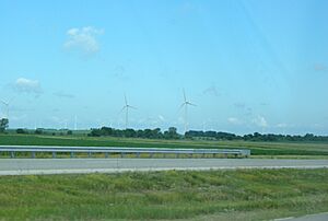
Benton County is known for its wind power!
In 2008, the Benton County Wind Farm started working. It has 87 huge wind turbines. These turbines make electricity that Duke Energy buys and sells to its customers.
Then, in 2009, the Fowler Ridge Wind Farm opened nearby. Because of these two farms, Benton County has one of the largest groups of wind turbines in the United States east of the Mississippi River. This means Benton County helps make a lot of clean energy!
Geography: Where is Benton County?
Benton County is on the western edge of Indiana, right next to Illinois. The land here has gentle, rolling hills. Most of the land is used for farming or buildings.
The lowest point in the county is about 453 feet (138 meters) high. The highest point is about 787 feet (240 meters) high. However, a small hill near Boswell is shown on maps as 915 feet (279 meters) above sea level.
Benton County covers about 406.51 square miles. Almost all of this (99.98%) is land, and a tiny bit (0.02%) is water.
Neighboring Counties
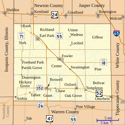
Benton County shares its borders with these counties:
- Newton County - to the northwest
- Jasper County - to the northeast
- White County - to the east
- Tippecanoe County - to the southeast
- Warren County - to the south
- Vermilion County, Illinois - to the southwest
- Iroquois County, Illinois - to the west
Cities and Towns in Benton County
Here are the main towns in Benton County:
Smaller Communities
Benton County also has several smaller, unincorporated communities:
- Atkinson
- Barce
- Chase
- Dunnington
- Freeland Park
- Gravel Hill
- Powley Corners (partly in Benton County)
- Raub
- Swanington
- Talbot
- Templeton
- Wadena
Townships
The county is divided into 11 townships:
- Bolivar
- Center
- Gilboa
- Grant
- Hickory Grove
- Oak Grove
- Parish Grove
- Pine
- Richland
- Union
- York
Main Roads and Railways
Important roads that go through Benton County include:
Railroads that pass through the county are:
- Bee Line Railroad
- Kankakee, Beaverville and Southern Railroad
Education: Schools in Benton County
The Benton Community School Corporation manages the public schools in the county.
- Benton Central Junior-Senior High School
- Otterbein Elementary School
- Prairie Crossing Elementary School
- Sacred Heart Elementary is the county's only private school.
Climate and Weather
| Weather chart for Fowler, Indiana | |||||||||||||||||||||||||||||||||||||||||||||||
|---|---|---|---|---|---|---|---|---|---|---|---|---|---|---|---|---|---|---|---|---|---|---|---|---|---|---|---|---|---|---|---|---|---|---|---|---|---|---|---|---|---|---|---|---|---|---|---|
| J | F | M | A | M | J | J | A | S | O | N | D | ||||||||||||||||||||||||||||||||||||
|
1.7
30
13
|
1.6
35
17
|
3.2
47
27
|
3.6
60
38
|
4.2
72
49
|
4.5
81
59
|
3.7
84
62
|
3
82
59
|
2.6
77
51
|
3
64
39
|
3
48
30
|
2.5
35
19
|
||||||||||||||||||||||||||||||||||||
| temperatures in °F precipitation totals in inches source: The Weather Channel |
|||||||||||||||||||||||||||||||||||||||||||||||
|
Metric conversion
|
|||||||||||||||||||||||||||||||||||||||||||||||
In Fowler, the average temperature in January is about 13°F (-11°C). In July, it's about 84°F (29°C). The coldest temperature ever recorded was -24°F (-31°C) in January 1999. The hottest was 99°F (37°C) in July 1995.
The county gets the most rain in June, about 4.50 inches (114 mm). February is usually the driest month, with about 1.59 inches (40 mm) of rain.
People of Benton County
| Historical population | |||
|---|---|---|---|
| Census | Pop. | %± | |
| 1850 | 1,144 | — | |
| 1860 | 2,809 | 145.5% | |
| 1870 | 5,615 | 99.9% | |
| 1880 | 11,108 | 97.8% | |
| 1890 | 11,903 | 7.2% | |
| 1900 | 13,123 | 10.2% | |
| 1910 | 12,688 | −3.3% | |
| 1920 | 12,206 | −3.8% | |
| 1930 | 11,886 | −2.6% | |
| 1940 | 11,117 | −6.5% | |
| 1950 | 11,462 | 3.1% | |
| 1960 | 11,912 | 3.9% | |
| 1970 | 11,262 | −5.5% | |
| 1980 | 10,218 | −9.3% | |
| 1990 | 9,441 | −7.6% | |
| 2000 | 9,421 | −0.2% | |
| 2010 | 8,854 | −6.0% | |
| 2020 | 8,720 | −1.5% | |
| 2023 (est.) | 8,729 | −1.4% | |
| US Decennial Census 1790-1960 1900-1990 1990-2000 2010 |
|||
In 2020, there were 8,719 people living in Benton County. Most people (92.1%) were White. About 5.4% of the population were of Hispanic or Latino background. Many people in the county have German (25.6%) or Irish (12.9%) family roots.
About 31.2% of homes had kids under 18 living there. The average family size was about 2.49 people. The average age of people in the county was 40.5 years old. About 18.5% of the population had a disability.
The average income for a household in the county was $49,488 per year. For families, it was $57,131. About 13.5% of the people lived below the poverty line. This included 19.4% of kids under 18.
Many people in Benton County work in different jobs. About 20.4% work in education and healthcare. Another 19.9% work in manufacturing. About 10.1% work in retail stores. And 8.6% work in farming or mining. It's cool to know that 35.4% of jobs in science, technology, engineering, and math are held by women!
In 2020, about 74% of people in Benton County owned their homes. The rest rented.
See also
 In Spanish: Condado de Benton (Indiana) para niños
 | Valerie Thomas |
 | Frederick McKinley Jones |
 | George Edward Alcorn Jr. |
 | Thomas Mensah |


