
Wabash and Erie Canal facts for kids
Quick facts for kids Wabash and Erie Canal |
|
|---|---|
.png)
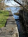
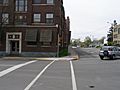
A restored section of canal in Delphi, Indiana
|
|
|
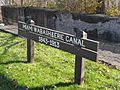
Indiana Register of Historic Sites
|
|
| Lua error in Module:Location_map at line 420: attempt to index field 'wikibase' (a nil value). |
The Wabash and Erie Canal was a very long waterway built by people. It connected the Great Lakes to the Ohio River. This canal helped traders move goods all the way from the Great Lakes to the Gulf of Mexico. It was over 460 miles long, making it the longest canal ever built in North America!
The canal we call the Wabash & Erie was actually made up of four different canals. These included the Miami and Erie Canal (from Toledo, Ohio, to Junction, Ohio), the original Wabash and Erie Canal (from Junction to Terre Haute, Indiana), the Cross Cut Canal (from Terre Haute to Worthington, Indiana), and the Central Canal (from Worthington to Evansville, Indiana).
Contents
Building the Canal


The United States Congress helped start the canal. They gave land in 1827 to help pay for its building. Indiana leaders accepted this gift in 1828. They realized the canal needed to go into Ohio too. Ohio then agreed to help with the project.
After some disagreements, Indiana decided to borrow money to start building. Construction began on February 22, 1832. The canal reached Logansport by 1837.
A big economic problem called the Panic of 1837 slowed things down. But it did not stop construction completely. The canal reached Lafayette by 1843. It got to Terre Haute by 1848 and Evansville by 1853.
In 1991, a special discovery was made. The Gronauer Lock was found in New Haven, Indiana. This was the only wooden lock found still in one piece. Part of it is now on display at the Indiana State Museum.
The higher parts of the canal were hard to keep working. They cost a lot to fix. One big problem was muskrats. These animals dug tunnels in the canal walls. When they dug through, water would rush out. This made the canal unusable until it was fixed.
How the Canal Worked
.png)
The canal started operating in the summer of 1843. But it only worked for about ten years. It became clear that the canal was not making enough money. Even when boats moved very slowly, the canal banks wore away quickly. The canal also needed constant cleaning to stay open.
The main office for the canal was in Terre Haute from 1847 to 1876. After that, the canal lands were sold.
The last canal boat trip on the Wabash Canal happened in 1874. This was in Huntington, Indiana. But other parts of the canal had already closed. In 1887, people in Paulding County, Ohio, drained a large water area. They were tired of mosquitoes breeding there. This event was called the Reservoir War. There were other "reservoir wars" too, for the same reason.
Later, a railway company bought the canal's path through Fort Wayne. This allowed the Nickel Plate Road railway to go right through the city. It was very handy for passengers and businesses. Part of the canal from Napoleon to Toledo was even paved over. It became U.S. Route 24.
Canal Route

The Wabash & Erie Canal stretched 497 miles. It went from Toledo, Ohio, on Lake Erie, to Evansville, Indiana, on the Ohio River.
The canal followed the Maumee River from Toledo to Fort Wayne, Indiana. From Fort Wayne, it followed an old Indian path to the Wabash River. It then went along the Wabash River downstream to Delphi. In Delphi, the canal crossed to the other side of the river. It continued down the Wabash to Terre Haute. From there, it turned southeast, using other waterways, until it reached the Ohio River in Evansville.
Maumee River Section
The Miami and Erie Canal also used part of this route. It went from Toledo to Cincinnati. The Wabash & Erie Canal used the route as far as Napoleon Bend to reach Lake Erie.
Some towns and cities along this shared route include:
- Toledo
- Bend View Metro park (with a towpath for walking)
- Side Cut Metro park (with a towpath and three locks)
- Providence (where a section of the canal still works)
- Maumee
- Waterville
- Providence/Grand Rapids (with locks and other canal features)
- Independence
Defiance At Defiance, the Miami and Erie Canal turned south. It went up the Auglaize River towards Cincinnati. The Wabash & Erie Canal, however, continued west. It followed the Maumee River to Fort Wayne, Indiana. The two canals separated at Junction, Ohio.
-
Two canals using the same path at Providence, Ohio.
-
Entrance from the Maumee River to the Miami and Erie.
-
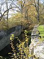
Providence lock looking west into the old canal bed.
-
Restoration of the mill and store at Providence.
.JPG)
.JPG)
.JPG)
.JPG)
New Haven, Indiana

The Gronauer Lock No. 2 was found here in 1991. It was discovered during road construction for I-469. This lock was built between 1838 and 1840. It was a rare, well-preserved wooden lock. It measured 115 by 40 feet. The inner chamber was 90 by 15 feet.
Many old items and 750 pieces of wood were found. After being treated to preserve them, a small part of the lock is now in an exhibit. This exhibit is at the Indiana State Museum. The Wabash and Erie Canal was America's longest canal. It connected Lake Erie at Toledo, Ohio, with the Ohio River at Evansville in 1853.
A historical marker was placed where the lock was found. This was near the interchange of I-469 and US-24. However, this marker has since been moved.
Fort Wayne was a special spot. It was where people used to carry boats between the Maumee River and the Wabash River. The canal crossed 5 miles here to the Little Wabash River. This was the highest point on the canal. Because of this, Fort Wayne became known as the "Summit City."
Wabash River Section
The canal continued through many towns along the Wabash River.
- Roanoke
- Huntington – The canal was 4 feet deep and 100 feet wide here. It was finished to Huntington in 1835. The canal came to Huntington 20 years before the railroad. This helped the town grow early on. The canal was no longer used here by 1873.
- Rook House – This was the first permanent hotel in Huntington. It was built in 1835 by General John Tipton. It stood right by the Wabash and Erie Canal. It was a busy place for business and social events. From 1862 to 1872, it was even one of the first public schools. It was destroyed in 1873.
- Forks of the Wabash Park (Museum)
-
Rook House Marker
-
Rook House
-
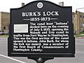
Burks Lock Historic Marker
-
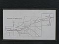
Map of the Wabash & Erie Canal
-
Historic Canal Route, now US 24


- Richvalley
- Peru
- Logansport
- Delphi – In Delphi, the canal crossed the Wabash River. A dam was built to create calm water for boats to cross. The Wabash & Erie Canal Interpretive Center is here. It has a re-watered section of the canal. Visitors can see a working canal boat, a bridge, and an old mill.
-
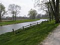
Water section of the canal in Delphi, Indiana
-
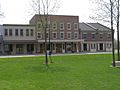
Reconstructed Canal Town - Canal Park Visitor Center


Cross Cut Canal Section
This section was between Terre Haute and Worthington. It was 42 miles long. It connected to the Central Canal. This gave a route to Evansville. Work started in 1836 but stopped in 1839. The project was finished in 1850. It served the canal system until 1861.
The Eel River Feeder Dam was built to supply water. It was 180 feet long and 16.5 feet high. It was completed in 1839. It helped keep enough water in the canal for boats.
West Fork of the White River

From Newberry south, the Wabash & Erie Canal followed the path of the Central Canal. The Central Canal was planned to go through Indianapolis. Only parts of it were built.
- Newberry
- Edwardsport
- Petersburg
- Francisco (where the Pigeon Creek section starts)
- Evansville, Indiana
You can see signs for the canal where Interstate 64 crosses Pigeon Creek.
Traveling on the Canal
People traveled along the canal in special boats called canal packets. There were boats for freight (goods) and boats for passengers. Passenger boats had different rooms. The main room was for meals. At night, it became a sleeping area for men. The ladies' room was at the back of the boat. It was where women slept.
Three horses or oxen, or a mix of both, pulled the packets. People who wrote in journals back then often mentioned problems. These included the heat, mosquitoes, and being very close to other passengers.
-
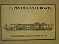
Passenger Packet, from the Canal Interpretive Center, Delphi, IN

Canal Museum
The Wabash & Erie Canal Interpretive Center is a museum in Delphi, Indiana. It is located right on the canal banks. The center has a model canal. It shows a miniature reservoir, aqueduct, lock, and gristmill.
A model canal boat called Gen. Grant is also there. It shows the kind of boats that carried goods. These boats were used in the canal's last years of full operation. The visitor center opened in 2003.
A local non-profit group runs the center. They work to preserve Indiana's canal history. The center is a great place to enjoy a 2.5-mile section of the canal. This part has been rebuilt and reopened for boats. It also has a walking path next to it. The museum is open daily, and there is an admission fee.
