
Indiana Central Canal facts for kids


The Indiana Central Canal was a big project in Indiana that aimed to connect the Wabash and Erie Canal to the Ohio River. It was part of Indiana's plan to build many canals, just like the famous Erie Canal in New York. This project was funded by the Mammoth Internal Improvement Act, which set aside $3.5 million for the canal. This was the largest part of the entire $10 million plan!
However, a major financial crisis called the Panic of 1837 hit the country. Because of this, Indiana faced serious money problems, and construction on the canal had to stop in 1839. The canal was supposed to be 296 kilometers (184 miles) long, stretching from Peru, Indiana, all the way to Evansville, Indiana, where it would meet the Ohio River. It was planned in two main parts, North and South, with a special "Indianapolis section" added later. In the end, only about 8 miles (13 kilometers) were fully built. Another 80 miles (129 kilometers) between Anderson, Indiana, and Martinsville, Indiana, were only partly finished.
Contents
History of the Canal
Before building began, the path for the canal was carefully surveyed by Jesse Williams, who was Indiana's canal engineer. The state of Indiana already owned most of the land needed for the canal. When built, the canal was designed to be six feet (about 1.8 meters) deep and sixty feet (about 18 meters) wide.
Northern Section Plans
The northern part of the canal was planned to go from Peru to Broad Ripple, Indiana. William Goody was the main surveyor for this section. It was supposed to use the Mississinewa River near Alexandria, Indiana, and then run alongside the White River. Only Delaware and Madison counties saw some digging, but not much was completed.
Indianapolis Section and Its Uses
The only fully completed 8 miles (13 kilometers) of the canal are in the Indianapolis area. This section runs alongside the White River. About 24 miles (39 kilometers) of this part were dug and filled with water, from Waverly, Indiana, to Broad Ripple. Building this section was tough because the land was undeveloped at the time.
Later in the 1800s, different water companies used this part of the canal. They used it to help power the water system in Indianapolis, which got its clean water from wells, not directly from the canal. In 1904, the Indianapolis Water Company (IWC) started using the partially built canal as a source for a water purification plant.
In the late 1960s, when Interstate 65 was being built, a part of the canal had to be moved underground. By 1969, the IWC stopped using the canal to power its pumping station. Then, in 1976, the IWC gave the part of the canal south of 16th Street to the city of Indianapolis. The city later started a big project in 1985 to clean, rebuild, and refill the downtown section of the canal. Today, some of this part of the Central Canal is inside White River State Park and also runs through the Indiana Government Center.
Southern Section Plans
The southern part of the canal was planned to go from Port Royal (now Waverly) to Evansville. Francis Cleveland was the main surveyor for this section. About 20 miles (32 kilometers) were attempted in Vanderburgh and Warrick counties, but not much was finished.
The Canal Today
Today, the Central Canal Towpath in Indianapolis is a popular trail that follows along a part of the completed 8 miles (13 kilometers) of the canal. It runs from Broad Ripple to 30th Street near Riverside Park. Along the way, it passes by Butler University and the Indianapolis Museum of Art.
The Indianapolis section of the canal is also home to six different kinds of turtles. Scientists study these turtles to learn how city environments affect wildlife. In 1971, the canal was recognized as an American Water Landmark by the American Water Works Association.
Gallery
-
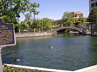
Closeup of the canal
-
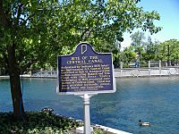
Historical marker by the canal in downtown Indianapolis
-
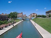
The canal as it passes the Indiana Historical Society
-
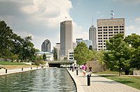
View of downtown skyline from the canal
-
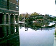
A reflection of a bridge in the portion of the canal that flows through downtown Indianapolis


