Vanderburgh County, Indiana facts for kids
Quick facts for kids
Vanderburgh County
|
||
|---|---|---|

|
||
|
||

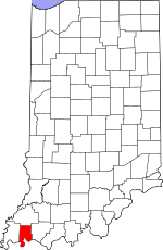
Location within the U.S. state of Indiana
|
||
 Indiana's location within the U.S. |
||
| Country | ||
| State | ||
| Founded | January 7, 1818 | |
| Named for | Henry Vanderburgh | |
| Seat | Evansville | |
| Largest city | Evansville | |
| Area | ||
| • Total | 236.33 sq mi (612.1 km2) | |
| • Land | 233.48 sq mi (604.7 km2) | |
| • Water | 2.86 sq mi (7.4 km2) 1.21%% | |
| Population
(2020)
|
||
| • Total | 180,136 | |
| • Estimate
(2023)
|
179,810 |
|
| • Density | 762.222/sq mi (294.296/km2) | |
| Time zone | UTC−6 (Central) | |
| • Summer (DST) | UTC−5 (CDT) | |
| Congressional district | 8th | |
|
||
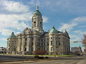
Vanderburgh County is a county located in the state of Indiana in the United States. In 2020, about 180,136 people lived here. The main city and county seat is Evansville.
Vanderburgh County is the eighth-largest county in Indiana by population. However, it is also the eighth-smallest county in size. It is the smallest county in southwestern Indiana, covering only about 236 square miles. Vanderburgh County is a central part of the Evansville metropolitan area.
Contents
Discovering Vanderburgh County's Past
Vanderburgh County was created on January 7, 1818. It was formed from parts of Gibson, Posey, and Warrick counties. The county was named after Captain Henry Vanderburgh. He was a brave soldier who fought in the American Revolutionary War. He also served as a judge for the Indiana Territory.
Exploring Vanderburgh County's Geography
In 2010, the county covered about 236.33 square miles. Most of this area, about 233.48 square miles, is land. The remaining 2.86 square miles is water.
Regional Location
Vanderburgh County is part of a special area. This area includes parts of three states:
- Illinois–Indiana–Kentucky tri-state area
- Southwestern Indiana
Neighboring Counties
Vanderburgh County shares its borders with several other counties:
- Gibson County to the north
- Posey County to the west
- Henderson County, Kentucky to the south
- Warrick County to the east
Cities and Towns in Vanderburgh County
The county is home to a few main cities and towns:
Special Census Areas
Some areas are called "census-designated places." These are like towns but are not officially incorporated.
Small Communities and Unincorporated Towns
Vanderburgh County also has many smaller, unincorporated communities. These are places where people live but do not have their own local government. Some examples include:
County Townships
Vanderburgh County is divided into several townships. These are smaller areas within the county that help with local services.
- Armstrong
- Center
- German
- Knight
- Perry
- Pigeon
- Scott
- Union
Main Roads and Highways
Several important highways run through Vanderburgh County. These roads help people travel around the county and to other places.
 I-64
I-64 I-69
I-69 US 41
US 41 SR 57
SR 57 SR 62
SR 62 SR 65
SR 65 SR 66
SR 66
Understanding Vanderburgh County's Climate
| Weather chart for Evansville, Indiana | |||||||||||||||||||||||||||||||||||||||||||||||
|---|---|---|---|---|---|---|---|---|---|---|---|---|---|---|---|---|---|---|---|---|---|---|---|---|---|---|---|---|---|---|---|---|---|---|---|---|---|---|---|---|---|---|---|---|---|---|---|
| J | F | M | A | M | J | J | A | S | O | N | D | ||||||||||||||||||||||||||||||||||||
|
3.1
42
25
|
3.3
48
29
|
4.5
59
37
|
4.5
70
46
|
4.8
79
55
|
4.2
87
64
|
4.1
91
69
|
3.1
90
67
|
3.2
83
60
|
3
72
48
|
4.3
58
39
|
3.7
46
29
|
||||||||||||||||||||||||||||||||||||
| temperatures in °F precipitation totals in inches source: The Weather Channel |
|||||||||||||||||||||||||||||||||||||||||||||||
|
Metric conversion
|
|||||||||||||||||||||||||||||||||||||||||||||||
The weather in Evansville, which is in Vanderburgh County, changes throughout the year. In January, the average low temperature is about 25°F. In July, the average high temperature reaches about 91°F.
The coldest temperature ever recorded was -17°F in January 1985. The hottest was 109°F in July 1954. The county also gets rain throughout the year. The driest month is usually October, with about 2.96 inches of rain. May is often the wettest, with about 4.78 inches.
Vanderburgh County's Population and People
| Historical population | |||
|---|---|---|---|
| Census | Pop. | %± | |
| 1820 | 1,798 | — | |
| 1830 | 2,611 | 45.2% | |
| 1840 | 6,250 | 139.4% | |
| 1850 | 11,414 | 82.6% | |
| 1860 | 20,552 | 80.1% | |
| 1870 | 33,145 | 61.3% | |
| 1880 | 42,193 | 27.3% | |
| 1890 | 59,809 | 41.8% | |
| 1900 | 71,769 | 20.0% | |
| 1910 | 77,438 | 7.9% | |
| 1920 | 92,293 | 19.2% | |
| 1930 | 113,320 | 22.8% | |
| 1940 | 130,783 | 15.4% | |
| 1950 | 160,422 | 22.7% | |
| 1960 | 165,794 | 3.3% | |
| 1970 | 168,772 | 1.8% | |
| 1980 | 167,515 | −0.7% | |
| 1990 | 165,058 | −1.5% | |
| 2000 | 171,922 | 4.2% | |
| 2010 | 179,703 | 4.5% | |
| 2020 | 180,136 | 0.2% | |
| 2023 (est.) | 179,810 | 0.1% | |
| U.S. Decennial Census 1790–1960 1900–1990 1990–2000 2010 |
|||
In 2010, there were 179,703 people living in Vanderburgh County. There were 74,454 households, which are groups of people living together. The population density was about 769.7 people per square mile.
Most people in the county, about 86.2%, were white. About 9.1% were black or African American. People of Asian descent made up 1.1% of the population. About 2.2% of the people were of Hispanic or Latino origin. Many families in the county have German, American, Irish, or English backgrounds.
About 28.9% of households had children under 18 living with them. Many households, 42.9%, were married couples. The average age of people in the county was 37.5 years old.
The average income for a household was $47,697 per year. For families, the average income was $57,076. About 15.6% of the population lived below the poverty line. This means their income was below a certain level needed to meet basic needs.
Learning in Vanderburgh County
All schools in Vanderburgh County are part of the Evansville-Vanderburgh School Corporation. This school system helps educate all the children in the county.
See also
 In Spanish: Condado de Vanderburgh para niños
 | Laphonza Butler |
 | Daisy Bates |
 | Elizabeth Piper Ensley |


