
Posey County, Indiana facts for kids
Quick facts for kids
Posey County
|
|
|---|---|

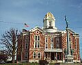
Posey County Courthouse in Mount Vernon
|
|

Location within the U.S. state of Indiana
|
|
 Indiana's location within the U.S. |
|
| Country | |
| State | |
| Founded | November 11, 1814 |
| Named for | Thomas Posey |
| Seat | Mount Vernon |
| Largest city | Mount Vernon |
| Area | |
| • Total | 419.32 sq mi (1,086.0 km2) |
| • Land | 409.57 sq mi (1,060.8 km2) |
| • Water | 9.75 sq mi (25.3 km2) |
| Population
(2020)
|
|
| • Total | 25,222 |
| • Estimate
(2023)
|
25,040 |
| • Density | 60.1498/sq mi (23.2240/km2) |
| Time zone | UTC−6 (Central) |
| • Summer (DST) | UTC−5 (CDT) |
| Congressional district | 8th |
|
|
Posey County is a county in the state of Indiana, USA. It is the southernmost, southwesternmost, and westernmost county in Indiana. The Ohio River forms its southern border. The Wabash River, which flows into the Ohio, makes up its western border.
In 2020, about 25,222 people lived in Posey County. The main town and county seat (where the county government is) is Mount Vernon. Posey County is also part of the larger Evansville metropolitan area, which is a group of cities and towns connected by jobs and daily life.
One important place in the county is the Ports of Indiana-Mount Vernon. This port is on the Ohio River. It is the seventh-largest inland port complex in the United States. Many goods, like grain from the Midwest, are shipped through this port.
Contents
History of Posey County
Posey County was created on November 11, 1814. It was formed from parts of Gibson and Warrick counties.
The county was named after Thomas Posey. He was a general during the American Revolutionary War. At the time, he was serving as the Governor of the Indiana Territory. The town of Mount Vernon became the county seat in 1825.
Geography and Landscape
Posey County covers a total area of about 419 square miles (1,086 square kilometers). Most of this area, about 410 square miles (1,061 square kilometers), is land. The rest, about 9.75 square miles (25 square kilometers), is water.
The lowest point in the entire state of Indiana is found in Posey County. This spot is on the Ohio River. It's where the Wabash River joins the Ohio River. From here, the water flows out of Indiana and into Illinois and Kentucky.
Neighboring Counties
Posey County shares its borders with several other counties:
- Gibson County - to the north and northeast
- Vanderburgh County - to the east
- Henderson County, Kentucky - to the southeast
- Union County, Kentucky - to the south
- Gallatin County, Illinois - to the southwest
- White County, Illinois - to the west and northwest
Cities and Towns in Posey County
Here are the main cities and towns you can find in Posey County:
Smaller Communities and Townships
Posey County also has many smaller communities and areas called townships.
- Bethel
- Black
- Center
- Harmony
- Lynn
- Marrs
- Point
- Robb
- Robinson
- Smith
There is also one census-designated place:
And many other small, unincorporated places:
- Barrett
- Blairsville
- Bufkin
- Caborn
- Dead Mans Crossing
- Erwin
- Farmersville
- Grafton
- Hepburn
- Heusler
- Hovey
- Lippe
- Marrs Center
- New Baltimore
- Oak Grove
- Oliver
- Philip Station
- Prairie
- Rapture
- Savah
- Solitude
- Springfield
- St. Philip
- St. Wendel
- Stewartsville
- Upton
- Wadesville
- Welborn Switch
- West Franklin
Transportation in Posey County
Posey County has important ways for people and goods to travel.
Major Roads
Several major highways pass through the county:
 I-64
I-64 SR 62
SR 62 SR 65
SR 65 SR 66
SR 66 SR 68
SR 68 SR 69
SR 69 SR 165
 SR 269
Railroads
Trains also play a role in transportation. The county is served by:
- CSX Transportation
- Evansville Western Railway
River Ports
The Ports of Indiana-Mt. Vernon is a very important river port. It is the seventh-largest inland port complex in the United States. This port moves over 4 million tons of cargo every year. It is a major hub for different types of transportation in the region.
The port handles many products. These include grain, coal, fertilizer, cement, and minerals. It is especially important for shipping grain from the area. This port is the largest public port within 175 miles of where the Ohio and Mississippi rivers meet.
Climate and Weather
| Weather chart for Mount Vernon, Indiana | |||||||||||||||||||||||||||||||||||||||||||||||
|---|---|---|---|---|---|---|---|---|---|---|---|---|---|---|---|---|---|---|---|---|---|---|---|---|---|---|---|---|---|---|---|---|---|---|---|---|---|---|---|---|---|---|---|---|---|---|---|
| J | F | M | A | M | J | J | A | S | O | N | D | ||||||||||||||||||||||||||||||||||||
|
3.4
38
23
|
3.2
44
26
|
4.6
54
35
|
4.4
65
45
|
5.4
75
55
|
4
84
64
|
4.1
87
68
|
3
86
65
|
2.7
80
58
|
2.9
69
46
|
4.4
55
37
|
3.7
43
27
|
||||||||||||||||||||||||||||||||||||
| temperatures in °F precipitation totals in inches source: The Weather Channel |
|||||||||||||||||||||||||||||||||||||||||||||||
|
Metric conversion
|
|||||||||||||||||||||||||||||||||||||||||||||||
The weather in Mount Vernon, Indiana, changes throughout the year. In January, the average low temperature is about 23°F (minus 5°C). In July, the average high temperature is about 87°F (31°C).
The coldest temperature ever recorded was minus 21°F (minus 29°C) in January 1912. The hottest was 109°F (43°C) in July 1901.
The amount of rain also varies. September usually has the least rain, about 2.65 inches (6.7 cm). May typically has the most, with about 5.38 inches (13.7 cm).
Population and People
| Historical population | |||
|---|---|---|---|
| Census | Pop. | %± | |
| 1820 | 4,061 | — | |
| 1830 | 6,549 | 61.3% | |
| 1840 | 9,683 | 47.9% | |
| 1850 | 12,549 | 29.6% | |
| 1860 | 16,167 | 28.8% | |
| 1870 | 19,185 | 18.7% | |
| 1880 | 20,857 | 8.7% | |
| 1890 | 21,529 | 3.2% | |
| 1900 | 22,333 | 3.7% | |
| 1910 | 21,670 | −3.0% | |
| 1920 | 19,334 | −10.8% | |
| 1930 | 17,853 | −7.7% | |
| 1940 | 19,183 | 7.4% | |
| 1950 | 19,818 | 3.3% | |
| 1960 | 19,214 | −3.0% | |
| 1970 | 21,740 | 13.1% | |
| 1980 | 26,414 | 21.5% | |
| 1990 | 25,968 | −1.7% | |
| 2000 | 27,061 | 4.2% | |
| 2010 | 25,910 | −4.3% | |
| 2020 | 25,222 | −2.7% | |
| 2023 (est.) | 25,040 | −3.4% | |
| US Decennial Census 1790-1960 1900-1990 1990-2000 2010 |
|||
In 2010, there were 25,910 people living in Posey County. These people lived in 10,171 households, with 7,442 of them being families. The population density was about 63 people per square mile.
Most of the people in the county were white (97.2%). Other groups included black or African American (0.9%), Asian (0.3%), and American Indian (0.2%). About 1.0% of the population was of Hispanic or Latino origin.
Many people in Posey County have German roots (43.6%). Other common backgrounds include American (13.6%), Irish (11.6%), and English (11.2%).
About 32.7% of households had children under 18 living with them. Most households (60.4%) were married couples. The average age of people in the county was 41.6 years.
The median income for a household was $47,697. For families, it was $68,722. The income per person in the county was $26,727. About 8.3% of all people lived below the poverty line. This included 12.2% of those under 18.
Education in Posey County
Posey County has two main school districts for public education:
- Mount Vernon Metropolitan School District
- North Posey County Schools Metropolitan School District
Public High Schools
Students in Posey County can attend these public high schools:
- Mount Vernon High School in Mount Vernon
- North Posey High School in Poseyville
The New Harmony Town and Township Consolidated Schools district used to cover part of the county. However, it closed in 2012 and joined the North Posey County Schools.
Fun Things to Do and See
Posey County offers several places for tourism and recreation:
- Posey County Stockyard
- Visit Posey County
- Brittlebank Park – Mount Vernon
- Harmonie State Park – New Harmony
- Hovey Lake State Fish & Wildlife Area – Mount Vernon
- New Harmony Historic District – New Harmony
- Sherburne Park – Mount Vernon
Images for kids
-
Posey County Courthouse in Mount Vernon
See also
 In Spanish: Condado de Posey para niños
