
White County, Illinois facts for kids
Quick facts for kids
White County
|
|
|---|---|

White County Courthouse in Carmi
|
|

Location within the U.S. state of Illinois
|
|
 Illinois's location within the U.S. |
|
| Country | |
| State | |
| Founded | 1815 |
| Named for | Isaac White |
| Seat | Carmi |
| Largest city | Carmi |
| Area | |
| • Total | 502 sq mi (1,300 km2) |
| • Land | 495 sq mi (1,280 km2) |
| • Water | 7.1 sq mi (18 km2) 1.4% |
| Population
(2020)
|
|
| • Total | 13,877 |
| • Estimate
(2023)
|
13,401 |
| • Density | 27.643/sq mi (10.673/km2) |
| Time zone | UTC−6 (Central) |
| • Summer (DST) | UTC−5 (CDT) |
| Congressional district | 12th |
White County is a place in the state of Illinois, in the United States. It's called a county. In 2020, about 13,877 people lived here. The main town, or county seat, is Carmi. White County is in the southern part of Illinois, an area sometimes called "Little Egypt".
Contents
History
White County was created in 1815 from a part of Gallatin County. It was named after Captain Leonard White. He was a lawmaker from Gallatin County. He had the idea to make the Illinois-Wisconsin border a bit further north. Sadly, he died in 1811.
The town of Carmi, the county seat, was started in 1814. It became an official town in 1816. The very first courthouse was a simple log cabin.
Early Settlers
The first white families moved to White County between 1807 and 1809. They settled near the Little Wabash River and a large open area called Big Prairie. These families often came from places like the Carolinas, Kentucky, or Tennessee. Many of them were of Scottish and Irish background. They often passed through Shawneetown, which was a busy port on the Ohio River.
Other early towns included Grayville, started around 1810. It was located where Bonpas Creek meets the Wabash River. Phillipstown was another early settlement. New Haven (mostly in Gallatin County) was home to a brother of famous explorer Daniel Boone around 1818. An old church, Sharon Church, was formed around 1816. The village of Seven Mile Prairie was set up nearby in the 1830s.
Around 1839, Irish families began moving into the western part of Enfield Township. Later, in the 1840s, German families also moved into the middle of the county.
Later Towns and Events
In the second half of the 1800s, many new towns were started. These included Norris City, Springerton, and Mill Shoals. Mill Shoals was once known for making barrels. Other towns like Epworth, Herald, and Crossville also grew. Some towns like Maunie and Rising Sun were on the Wabash River. They attracted several African-American families.
In 1925, White County was hit by a very strong storm called the Tri-State Tornado. This tornado caused a lot of damage in rural areas. It killed 28 people and hurt many more. Many homes and farms were destroyed.
Oil and Industry
For a long time, farming was the main way people made a living in White County. But in 1939, oil was found in the area. This discovery changed everything! The population of Carmi quickly doubled in just two years. Many oil workers moved here from other states like Texas and Oklahoma. Today, oil is still an important industry.
The current population of White County is around 13,400 people. Many people work in nearby cities in Indiana, like Evansville and Mount Vernon. Besides oil and farming, other jobs include making car parts, plastics, and coal mining.
In 1972, White County was the location of a large music event called the Erie Canal Soda Pop Festival.
-
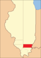
White County between its 1815 creation and 1818
-
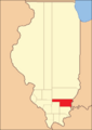
White County between 1818 and 1819
-
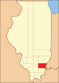
White County between 1819 and 1821
-
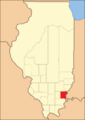
White County in 1821, reduced to its current borders by the creation of Hamilton County


Geography
White County covers a total area of about 502 square miles. Most of this (495 square miles) is land. The rest (7.1 square miles) is water, making up about 1.4% of the total area.
Climate and Weather
| Weather chart for Carmi, Illinois | |||||||||||||||||||||||||||||||||||||||||||||||
|---|---|---|---|---|---|---|---|---|---|---|---|---|---|---|---|---|---|---|---|---|---|---|---|---|---|---|---|---|---|---|---|---|---|---|---|---|---|---|---|---|---|---|---|---|---|---|---|
| J | F | M | A | M | J | J | A | S | O | N | D | ||||||||||||||||||||||||||||||||||||
|
3.1
40
22
|
3
46
26
|
4.4
57
35
|
4.2
68
44
|
5
77
53
|
4.6
86
63
|
4.6
89
67
|
3.6
88
64
|
3.1
81
57
|
2.6
70
44
|
4.2
56
36
|
4
44
26
|
||||||||||||||||||||||||||||||||||||
| temperatures in °F precipitation totals in inches source: The Weather Channel |
|||||||||||||||||||||||||||||||||||||||||||||||
|
Metric conversion
|
|||||||||||||||||||||||||||||||||||||||||||||||
In Carmi, the main town, temperatures usually range from 22°F in January to 89°F in July. The coldest temperature ever recorded was -20°F in January 1994. The hottest was 103°F in August 2007. The county gets about 2.61 inches of rain in October and up to 5.00 inches in May.
Transportation
- Rides Mass Transit District
Main Roads
 Interstate 64
 U.S. Highway 45
 Illinois Route 1
 Illinois Route 14
 Illinois Route 141
Neighboring Counties
White County shares borders with these other counties:
- Edwards County (to the north)
- Gibson County, Indiana (to the northeast)
- Posey County, Indiana (to the east)
- Gallatin County (to the south)
- Saline County (to the southwest)
- Hamilton County (to the west)
- Wayne County (to the northwest)
People and Population
| Historical population | |||
|---|---|---|---|
| Census | Pop. | %± | |
| 1820 | 4,828 | — | |
| 1830 | 6,091 | 26.2% | |
| 1840 | 7,919 | 30.0% | |
| 1850 | 8,925 | 12.7% | |
| 1860 | 12,403 | 39.0% | |
| 1870 | 16,846 | 35.8% | |
| 1880 | 23,087 | 37.0% | |
| 1890 | 25,005 | 8.3% | |
| 1900 | 25,386 | 1.5% | |
| 1910 | 23,052 | −9.2% | |
| 1920 | 20,081 | −12.9% | |
| 1930 | 18,149 | −9.6% | |
| 1940 | 20,027 | 10.3% | |
| 1950 | 20,935 | 4.5% | |
| 1960 | 19,373 | −7.5% | |
| 1970 | 17,312 | −10.6% | |
| 1980 | 17,864 | 3.2% | |
| 1990 | 16,522 | −7.5% | |
| 2000 | 15,371 | −7.0% | |
| 2010 | 14,665 | −4.6% | |
| 2020 | 13,877 | −5.4% | |
| 2023 (est.) | 13,401 | −8.6% | |
| U.S. Decennial Census 1790-1960 1900-1990 1990-2000 2010-2013 |
|||
In 2010, there were 14,665 people living in White County. Most people (98.1%) were white. About 1.1% of the population was of Hispanic or Latino background. Many families had German, Irish, American, or English roots.
The average age of people in White County was 45.2 years old. About 27.3% of households had children under 18 living with them. The average household had 2.26 people.
The average yearly income for a household was $39,728. For families, it was $48,666. About 14.8% of all people in the county lived below the poverty line. This included 25.7% of those under 18.
Communities
Cities
Villages
Unincorporated Towns
Townships
White County is divided into ten smaller areas called townships:
- Burnt Prairie
- Carmi
- Emma
- Enfield
- Gray
- Hawthorne
- Heralds Prairie
- Indian Creek
- Mill Shoals
- Phillips
Education
Here are the school districts in White County:
- Carmi-White County Community Unit School District 5
- Gallatin Community Unit School District 7
- Grayville Community Unit School District 1
- Norris City-Omaha-Enfield Community Unit School District 3
- Fairfield Community High School District 225 (for high school grades only)
- New Hope Community Consolidated School District 6 (for elementary grades only)
See also
 In Spanish: Condado de White (Illinois) para niños
