
Saline County, Illinois facts for kids
Quick facts for kids
Saline County
|
||
|---|---|---|

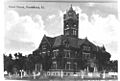
Former Saline County Courthouse in Harrisburg
|
||
|
||

Location within the U.S. state of Illinois
|
||
 Illinois's location within the U.S. |
||
| Country | ||
| State | ||
| Founded | 1847 | |
| Named for | Saline River | |
| Seat | Harrisburg | |
| Largest city | Harrisburg | |
| Area | ||
| • Total | 387 sq mi (1,000 km2) | |
| • Land | 380 sq mi (1,000 km2) | |
| • Water | 7.0 sq mi (18 km2) 1.8% | |
| Population
(2020)
|
||
| • Total | 23,768 | |
| • Density | 61.42/sq mi (23.713/km2) | |
| Time zone | UTC−6 (Central) | |
| • Summer (DST) | UTC−5 (CDT) | |
| Congressional district | 12th | |

Saline County is a place in Southern Illinois. It's called a county, which is like a smaller area within a state. In 2020, about 23,768 people lived here. The biggest city and the main government center, called the county seat, is Harrisburg. People in this part of Southern Illinois sometimes call the area "Little Egypt".
Three important towns in Saline County are connected by U.S. Route 45. These towns are Eldorado, Harrisburg, and Carrier Mills. Long ago, a railroad also connected them.
Contents
Exploring Saline County's Geography
Saline County covers about 387 square miles. Most of this area, about 380 square miles, is land. The rest, about 7 square miles, is water.
The land in Saline County has many rolling hills. These hills slowly get taller as you go towards the Hills of the Shawnee National Forest. The Saline River flows through the middle of the county. It has three main parts: the North, Middle, and South forks. North of Eldorado, the land is flatter and lower.
Weather and Climate in Saline County
| Weather chart for Harrisburg, Illinois | |||||||||||||||||||||||||||||||||||||||||||||||
|---|---|---|---|---|---|---|---|---|---|---|---|---|---|---|---|---|---|---|---|---|---|---|---|---|---|---|---|---|---|---|---|---|---|---|---|---|---|---|---|---|---|---|---|---|---|---|---|
| J | F | M | A | M | J | J | A | S | O | N | D | ||||||||||||||||||||||||||||||||||||
|
3.2
40
22
|
3.1
46
25
|
4.4
57
35
|
4.6
68
45
|
5
77
54
|
4.5
85
63
|
3.9
89
68
|
3.2
88
65
|
3
81
57
|
3
70
44
|
4.2
56
36
|
3.9
45
26
|
||||||||||||||||||||||||||||||||||||
| temperatures in °F precipitation totals in inches source: The Weather Channel |
|||||||||||||||||||||||||||||||||||||||||||||||
|
Metric conversion
|
|||||||||||||||||||||||||||||||||||||||||||||||
The weather in Saline County changes with the seasons. In Harrisburg, the county seat, average temperatures are around 22 degrees Fahrenheit in January. In July, they can reach about 89 degrees Fahrenheit. The county also gets rain throughout the year. On average, it rains about 3 to 5 inches each month.
Neighboring Counties
Saline County shares its borders with several other counties.
- Hamilton County (north)
- White County (northeast)
- Gallatin County (east)
- Hardin County (southeast)
- Pope County (south)
- Johnson County (southwest)
- Williamson County (west)
- Franklin County (northwest)
Protected Natural Areas
Part of the Shawnee National Forest is located in Saline County. This is a large area of protected land. There are also two state-protected areas:
- Sahara Woods State Fish and Wildlife Area
- Saline County State Fish and Wildlife Area
Getting Around Saline County
Public Transportation
- Rides Mass Transit District helps people get around the county.
Main Roads
Several important highways run through Saline County, making it easy to travel.
 U.S. Highway 45
 Illinois Route 13
 Illinois Route 34
 Illinois Route 142
 Illinois Route 145
People of Saline County
| Historical population | |||
|---|---|---|---|
| Census | Pop. | %± | |
| 1850 | 5,588 | — | |
| 1860 | 9,331 | 67.0% | |
| 1870 | 12,714 | 36.3% | |
| 1880 | 15,940 | 25.4% | |
| 1890 | 19,342 | 21.3% | |
| 1900 | 21,685 | 12.1% | |
| 1910 | 30,204 | 39.3% | |
| 1920 | 38,353 | 27.0% | |
| 1930 | 37,100 | −3.3% | |
| 1940 | 38,066 | 2.6% | |
| 1950 | 33,420 | −12.2% | |
| 1960 | 26,227 | −21.5% | |
| 1970 | 25,721 | −1.9% | |
| 1980 | 28,448 | 10.6% | |
| 1990 | 26,551 | −6.7% | |
| 2000 | 26,733 | 0.7% | |
| 2010 | 24,913 | −6.8% | |
| 2020 | 23,768 | −4.6% | |
| 2023 (est.) | 22,873 | −8.2% | |
| U.S. Decennial Census 1790-1960 1900-1990 1990-2000 2010-2013 |
|||
In 2010, about 24,913 people lived in Saline County. Most people living here are white, but there are also African American, Asian, and American Indian residents. About 1.4% of the population is of Hispanic or Latino background. The average age of people in Saline County was about 41.7 years old.
Towns and Villages
Saline County has several cities and smaller communities.
Cities
Villages
- Carrier Mills (also known as Morrilsville)
- Galatia
- Muddy
- Raleigh
- Stonefort (partly in Williamson County)
Smaller Communities
These are smaller places that are not officially cities or villages.
- Buena Vista
- Cottage Grove
- Delta
- Derby
- Eagle
- Harco
- Lakeview (also known as Pond Settlement)
- Ledford
- Liberty
- Mitchellsville
- New Hope
- Pankeyville
- Rudement
- Somerset
- Texas City
- Wasson
- West End
Townships
Saline County is divided into 13 smaller areas called townships. These help with local government and services.
- Brushy
- Carrier Mills
- Cottage
- East Eldorado
- Galatia
- Harrisburg
- Independence
- Long Branch
- Mountain
- Raleigh
- Rector
- Stone Fort
- Tate
Images for kids
-
Former Saline County Courthouse in Harrisburg
See also
 In Spanish: Condado de Saline (Illinois) para niños
