
Johnson County, Illinois facts for kids
Quick facts for kids
Johnson County
|
|
|---|---|

Johnson County Courthouse in Vienna
|
|

Location within the U.S. state of Illinois
|
|
 Illinois's location within the U.S. |
|
| Country | |
| State | |
| Founded | 1812 |
| Named for | Richard Mentor Johnson |
| Seat | Vienna |
| Largest city | Vienna |
| Area | |
| • Total | 349 sq mi (900 km2) |
| • Land | 344 sq mi (890 km2) |
| • Water | 4.9 sq mi (13 km2) 1.4% |
| Population
(2020)
|
|
| • Total | 13,308 |
| • Estimate
(2023)
|
13,326 |
| • Density | 38.13/sq mi (14.723/km2) |
| Time zone | UTC−6 (Central) |
| • Summer (DST) | UTC−5 (CDT) |
| Congressional district | 12th |
Johnson County is a county in the state of Illinois, USA. In 2020, about 13,308 people lived there. The main town and county seat is Vienna. Johnson County is in the southern part of Illinois, an area sometimes called "Little Egypt".
Contents
History of Johnson County

Johnson County was created in 1812. It was formed from parts of Randolph County. The county was named after Richard Mentor Johnson. He was a U.S. Congressman from Kentucky at that time.
In 1813, Richard M. Johnson led a group of soldiers from Kentucky. They fought in the Battle of the Thames. After this battle, he said he had defeated a famous Native American leader named Tecumseh. Later, Johnson became the Vice President of the United States.
-
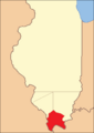
Johnson County when it was first created in 1812
-
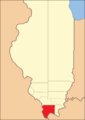
Johnson County between 1816 and 1818
-
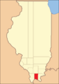
Johnson County between 1818 and 1843
-
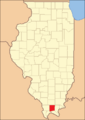
Johnson County in 1843, when it became its current size


Geography of Johnson County
Johnson County covers about 349 square miles. Most of this area, about 344 square miles, is land. The rest, about 4.9 square miles, is water.
Climate and Weather in Johnson County
| Weather chart for Vienna, Illinois | |||||||||||||||||||||||||||||||||||||||||||||||
|---|---|---|---|---|---|---|---|---|---|---|---|---|---|---|---|---|---|---|---|---|---|---|---|---|---|---|---|---|---|---|---|---|---|---|---|---|---|---|---|---|---|---|---|---|---|---|---|
| J | F | M | A | M | J | J | A | S | O | N | D | ||||||||||||||||||||||||||||||||||||
|
3.4
43
25
|
3.4
50
29
|
4.6
60
38
|
4.7
71
46
|
5.2
79
55
|
4.1
87
63
|
3.8
90
67
|
3.6
90
65
|
3.3
84
58
|
3.2
73
47
|
4.7
59
39
|
4.4
47
29
|
||||||||||||||||||||||||||||||||||||
| temperatures in °F precipitation totals in inches source: The Weather Channel |
|||||||||||||||||||||||||||||||||||||||||||||||
|
Metric conversion
|
|||||||||||||||||||||||||||||||||||||||||||||||
In Vienna, the main town, temperatures change throughout the year. In January, the average low is about 25°F (about -4°C). In July, the average high is about 90°F (about 32°C).
The lowest temperature ever recorded was -20°F (about -29°C) in January 1977. The highest was 103°F (about 39°C) in August 2007. The county gets the most rain in May and the least in October.
Main Roads in Johnson County
 Interstate 24
 Interstate 57
 U.S. Route 45
 Illinois Route 37
 Illinois Route 146
 Illinois Route 147
 Illinois Route 166
Neighboring Counties
Johnson County shares borders with these counties:
- Williamson County - to the north
- Saline County - to the northeast
- Pope County - to the east
- Massac County - to the southeast
- Pulaski County - to the southwest
- Union County - to the west
Protected Natural Areas
Parts of these natural areas are in Johnson County:
- Cypress Creek National Wildlife Refuge
- Shawnee National Forest
Population and People (Demographics)
| Historical population | |||
|---|---|---|---|
| Census | Pop. | %± | |
| 1820 | 843 | — | |
| 1830 | 1,596 | 89.3% | |
| 1840 | 3,626 | 127.2% | |
| 1850 | 4,114 | 13.5% | |
| 1860 | 9,342 | 127.1% | |
| 1870 | 11,248 | 20.4% | |
| 1880 | 13,078 | 16.3% | |
| 1890 | 15,013 | 14.8% | |
| 1900 | 15,667 | 4.4% | |
| 1910 | 14,331 | −8.5% | |
| 1920 | 12,022 | −16.1% | |
| 1930 | 10,203 | −15.1% | |
| 1940 | 10,727 | 5.1% | |
| 1950 | 8,729 | −18.6% | |
| 1960 | 6,928 | −20.6% | |
| 1970 | 7,550 | 9.0% | |
| 1980 | 9,624 | 27.5% | |
| 1990 | 11,347 | 17.9% | |
| 2000 | 12,878 | 13.5% | |
| 2010 | 12,582 | −2.3% | |
| 2020 | 13,308 | 5.8% | |
| 2023 (est.) | 13,326 | 5.9% | |
| U.S. Decennial Census 1790-1960 1900-1990 1990-2000 2010 |
|||
In 2010, there were 12,582 people living in Johnson County. Most people were white (89.0%). About 8.0% were black or African American. Other groups included Asian, Native American, and people of two or more races. About 3.0% of the population was Hispanic or Latino.
The average age in the county was 42.2 years. Many households had children under 18. Most households were married couples living together.
Towns and Villages
Cities
- Marion (mostly in Williamson County)
- Vienna
Villages
Unincorporated Communities
- Bloomfield
- Crossroads
- Dixon Springs
- Elvira
- Ganntown
- Grantsburg
- Ozark
- Parker City
- Pleasant Grove
- Pond
- Reevesville
- Reynoldsburg
- Tunnel Hill
- West Vienna
- White Hill
Education in Johnson County
Here are some of the school districts in Johnson County:
Schools for All Grades (K-12)
- Century Community Unit School District 100
- Goreville Community Unit School District 1
- Marion Community Unit School District 2
High Schools
- Vienna High School District 133
Elementary Schools
- Buncombe Consolidated School District 43
- Cypress School District 64
- New Simpson Hill Consolidated District 32
- Vienna School District 55
Images for kids
-
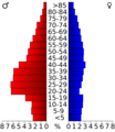
Age pyramid for Johnson County in 2000

See also
 In Spanish: Condado de Johnson (Illinois) para niños
