
Pulaski County, Illinois facts for kids
Quick facts for kids
Pulaski County
|
|
|---|---|

Pulaski County Courthouse in Mound City
|
|

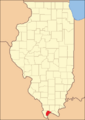
Location within the U.S. state of Illinois
|
|
 Illinois's location within the U.S. |
|
| Country | |
| State | |
| Founded | 1843 |
| Named for | Casimir Pulaski |
| Seat | Mound City |
| Largest city | Mounds |
| Area | |
| • Total | 203 sq mi (530 km2) |
| • Land | 199 sq mi (520 km2) |
| • Water | 4.0 sq mi (10 km2) 2.0% |
| Population
(2020)
|
|
| • Total | 5,193 |
| • Estimate
(2023)
|
4,911 |
| • Density | 25.58/sq mi (9.877/km2) |
| Time zone | UTC−6 (Central) |
| • Summer (DST) | UTC−5 (CDT) |
| Congressional district | 12th |
Pulaski County is a county located in the southern part of Illinois, a state in the United States. In 2020, about 5,193 people lived here. The main town, or county seat, is Mound City. The biggest town is Mounds. Pulaski County is found along the Ohio River and is part of a region often called "Little Egypt".
Contents
History of Pulaski County
Pulaski County was officially created on March 3, 1843. It was formed from parts of two nearby counties: Alexander and Johnson. The county was named to honor Casimir Pułaski. He was a brave soldier who fought and died in the Revolutionary War during the siege of Savannah.
-
Pulaski County when it was first created in 1843

Geography and Nature
Pulaski County covers a total area of about 203 square miles. Most of this area, about 199 square miles, is land. The remaining 4 square miles (which is 2%) is water. This makes Pulaski County the third smallest county in Illinois by land area.
Weather and Climate
| Weather chart for Mound City, Illinois | |||||||||||||||||||||||||||||||||||||||||||||||
|---|---|---|---|---|---|---|---|---|---|---|---|---|---|---|---|---|---|---|---|---|---|---|---|---|---|---|---|---|---|---|---|---|---|---|---|---|---|---|---|---|---|---|---|---|---|---|---|
| J | F | M | A | M | J | J | A | S | O | N | D | ||||||||||||||||||||||||||||||||||||
|
3.2
41
26
|
3.6
48
30
|
4.4
58
39
|
4.7
69
50
|
4.8
78
59
|
4.2
86
67
|
4.4
90
71
|
3.6
87
69
|
3
81
61
|
3.4
71
49
|
4.4
57
39
|
4.2
46
30
|
||||||||||||||||||||||||||||||||||||
| temperatures in °F precipitation totals in inches source: The Weather Channel |
|||||||||||||||||||||||||||||||||||||||||||||||
|
Metric conversion
|
|||||||||||||||||||||||||||||||||||||||||||||||
In Mound City, the county seat, temperatures usually range from about 26°F in January to 90°F in July. However, it can get much colder or hotter! The lowest temperature ever recorded was -12°F in January 1985. The highest was 104°F in June 1954. The amount of rain and snow changes throughout the year. September usually has the least amount of rain, while May often has the most.
Main Roads and Highways
Several important roads pass through Pulaski County, connecting it to other areas.
 Interstate 57
 U.S. Highway 51
 Illinois Route 3
 Illinois Route 37
 Illinois Route 169
Neighboring Counties
Pulaski County shares its borders with several other counties:
- Union County (to the north)
- Johnson County (to the northeast)
- Massac County (to the east)
- Ballard County, Kentucky (to the southeast, across the Ohio River)
- Alexander County (to the west)
Protected Natural Areas
Part of the Cypress Creek National Wildlife Refuge is located within Pulaski County. This area helps protect different kinds of wildlife and their homes.
Population and People
| Historical population | |||
|---|---|---|---|
| Census | Pop. | %± | |
| 1850 | 2,265 | — | |
| 1860 | 3,943 | 74.1% | |
| 1870 | 8,752 | 122.0% | |
| 1880 | 9,507 | 8.6% | |
| 1890 | 11,355 | 19.4% | |
| 1900 | 14,554 | 28.2% | |
| 1910 | 15,650 | 7.5% | |
| 1920 | 14,629 | −6.5% | |
| 1930 | 14,834 | 1.4% | |
| 1940 | 15,875 | 7.0% | |
| 1950 | 13,639 | −14.1% | |
| 1960 | 10,490 | −23.1% | |
| 1970 | 8,741 | −16.7% | |
| 1980 | 8,840 | 1.1% | |
| 1990 | 7,523 | −14.9% | |
| 2000 | 7,348 | −2.3% | |
| 2010 | 6,161 | −16.2% | |
| 2020 | 5,193 | −15.7% | |
| 2023 (est.) | 4,911 | −20.3% | |
| U.S. Decennial Census 1790-1960 1900-1990 1990-2000 2010-2020 2020 |
|||
In 2010, there were 6,161 people living in Pulaski County. About 2,642 homes were counted. The average household had about 2.32 people. The average age of people living in the county was 43.2 years old.
Towns and Villages
Pulaski County has several communities where people live and work.
Cities
- Mound City (the county seat)
- Mounds (the largest city)
Villages
- Karnak
- New Grand Chain (often called "Grand Chain")
- Olmsted
- Pulaski
- Ullin
Smaller Communities
See also
 In Spanish: Condado de Pulaski (Illinois) para niños
