
Randolph County, Illinois facts for kids
Quick facts for kids
Randolph County
|
|
|---|---|

Randolph County Courthouse in Chester
|
|
| Motto(s):
Where Illinois Began
|
|

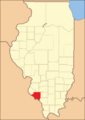
Location within the U.S. state of Illinois
|
|
 Illinois's location within the U.S. |
|
| Country | |
| State | |
| Founded | 1795 |
| Named for | Edmund Randolph |
| Seat | Chester |
| Largest city | Chester |
| Area | |
| • Total | 597 sq mi (1,550 km2) |
| • Land | 576 sq mi (1,490 km2) |
| • Water | 22 sq mi (60 km2) 3.6% |
| Population
(2020)
|
|
| • Total | 30,163 |
| • Density | 50.52/sq mi (19.508/km2) |
| Time zone | UTC−6 (Central) |
| • Summer (DST) | UTC−5 (CDT) |
| Congressional district | 12th |
Randolph County is a county in the state of Illinois, USA. In 2020, about 30,163 people lived there. The main town, or county seat, is Chester.
This county is very important to Illinois history. Its motto is "Where Illinois Began." It is home to Kaskaskia, which was the first capital city of Illinois.
Randolph County is in the southern part of Illinois, an area sometimes called "Little Egypt." It has rich, flat land near rivers and is close to the Greater St. Louis area.
Contents
History of Randolph County
Randolph County was created in 1795. It was formed from a part of St. Clair County. The county was named after Edmund Randolph, who was the Governor of Virginia.
George Rogers Clark and his army from Virginia took control of this area from the British on July 4, 1778. This happened near the end of the Revolutionary War. For some years, this area was part of Illinois County, Virginia.
Later, in 1787, the United States Congress created the Northwest Territory. Edmund Randolph was still Governor of Virginia when Virginia gave this territory to the United States.
In 1809, Illinois became its own territory. Nathaniel Pope, who was acting as governor, officially made Randolph one of Illinois' first two counties. The county's borders were last changed in 1827. At that time, some land was used to create Perry County.
The Mississippi River has greatly shaped the county's history. In 1881, the river changed its path. It cut off Kaskaskia from the rest of Illinois. This change destroyed the original village of Kaskaskia. Its historic cemetery had to be moved across the river to Fort Kaskaskia.
Crains Island, near Chester, is another piece of Illinois land that ended up west of the Mississippi River because the river changed course.
-
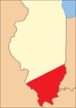
Randolph County when it was re-established in 1809.
-
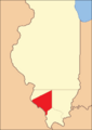
Randolph County between 1812 and 1813.
-
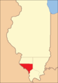
Randolph County between 1813 and 1816.
-
Randolph County between 1816 and 1827.
-
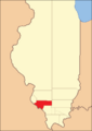
Randolph County in 1827, with its current borders.


Geography and Climate
Randolph County covers about 597 square miles. Most of this, 576 square miles, is land. The remaining 22 square miles, or 3.6%, is water.
The Kaskaskia River flows into the Mississippi River in Randolph County. At this point, the Mississippi River is entirely within Illinois. This is unusual because the Mississippi usually forms the border between Illinois and Missouri.
The Mississippi River changed its path in the late 1800s. This left Kaskaskia, the old state capital, on the west side of the river. However, the state border still follows the river's old path. This means Illinois has a small piece of land on the western side of the Mississippi River. A smaller area, Crains Island, is a few miles downriver.
Weather in Randolph County
| Weather chart for Chester, Illinois | |||||||||||||||||||||||||||||||||||||||||||||||
|---|---|---|---|---|---|---|---|---|---|---|---|---|---|---|---|---|---|---|---|---|---|---|---|---|---|---|---|---|---|---|---|---|---|---|---|---|---|---|---|---|---|---|---|---|---|---|---|
| J | F | M | A | M | J | J | A | S | O | N | D | ||||||||||||||||||||||||||||||||||||
|
1.9
39
22
|
2
46
26
|
3.5
56
35
|
3.4
68
45
|
4.3
78
54
|
3.9
87
64
|
3.8
91
68
|
3.4
89
66
|
3.2
82
58
|
3.1
71
46
|
4.2
56
36
|
3.2
44
27
|
||||||||||||||||||||||||||||||||||||
| temperatures in °F precipitation totals in inches source: The Weather Channel |
|||||||||||||||||||||||||||||||||||||||||||||||
|
Metric conversion
|
|||||||||||||||||||||||||||||||||||||||||||||||
In Chester, the county seat, temperatures usually range from 22°F (about -5°C) in January to 91°F (about 33°C) in July. The coldest temperature ever recorded was -18°F (-28°C) in January 1985. The hottest was 113°F (45°C) in July 2012.
The amount of rain each month varies. January usually gets about 1.85 inches (4.7 cm) of rain. May is the wettest month, with about 4.30 inches (10.9 cm) of rain.
Main Roads
 Illinois Route 3
 Illinois Route 4
 Illinois Route 13
 Illinois Route 150
 Illinois Route 153
 Illinois Route 154
 Illinois Route 155
 Illinois Route 159
Neighboring Counties
Randolph County shares borders with these counties:
- Monroe County (northwest)
- St. Clair County (north)
- Washington County (northeast)
- Perry County (east)
- Jackson County (southeast)
- Perry County, Missouri (south)
- Ste. Genevieve County, Missouri (southwest)
Randolph County is one of the few counties in the United States that borders two counties with the same name. These are Perry County in Illinois and Perry County in Missouri.
People of Randolph County
| Historical population | |||
|---|---|---|---|
| Census | Pop. | %± | |
| 1820 | 3,492 | — | |
| 1830 | 4,429 | 26.8% | |
| 1840 | 7,944 | 79.4% | |
| 1850 | 11,079 | 39.5% | |
| 1860 | 17,205 | 55.3% | |
| 1870 | 20,859 | 21.2% | |
| 1880 | 25,690 | 23.2% | |
| 1890 | 25,049 | −2.5% | |
| 1900 | 28,001 | 11.8% | |
| 1910 | 29,120 | 4.0% | |
| 1920 | 29,109 | 0.0% | |
| 1930 | 29,313 | 0.7% | |
| 1940 | 33,608 | 14.7% | |
| 1950 | 31,673 | −5.8% | |
| 1960 | 29,988 | −5.3% | |
| 1970 | 31,379 | 4.6% | |
| 1980 | 35,652 | 13.6% | |
| 1990 | 34,583 | −3.0% | |
| 2000 | 33,893 | −2.0% | |
| 2010 | 33,476 | −1.2% | |
| 2020 | 30,163 | −9.9% | |
| 2023 (est.) | 29,815 | −10.9% | |
| U.S. Decennial Census 1790–1960 1900–1990 1990–2000 2010–20132020 United States census |
|||
In 2010, there were 33,476 people living in Randolph County. There were 12,314 households and 8,188 families. The county had about 58 people per square mile.
Most people (87.6%) were white. About 9.7% were black or African American. People of Hispanic or Latino origin made up 2.6% of the population.
Many people in the county have German (40.3%), Irish (11.3%), or English (9.4%) family backgrounds.
About 29.1% of households had children under 18 living with them. The average household had 2.37 people. The average family had 2.90 people. The average age of people in the county was 41 years old.
The average income for a household was $45,020. For a family, it was $55,113. About 10.4% of all people in the county lived below the poverty line. This included 11.9% of those under 18.
Local Media
Randolph County has two AM radio stations:
- WHCO 1230AM in Sparta
- KSGM 980AM in Chester
There are also several weekly newspapers:
- The Randolph County Herald Tribune (Chester)
- The County Journal (Percy, also covers Perry and Jackson Counties)
- North County News (Red Bud)
- Sparta News-Plaindealer
An online newspaper, SunTimesNews.com, based in Chester, also serves the area.
Towns and Villages
Cities
Villages
Unincorporated Communities
Historic Forts
See also
 In Spanish: Condado de Randolph (Illinois) para niños
