Fort de Chartres facts for kids
|
Fort de Chartres
|
|
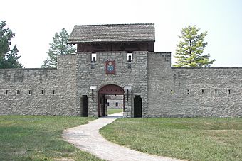
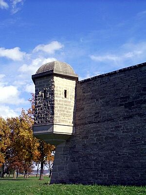
The gatehouse of Fort de Chartres was reconstructed in the 1930s.
|
|
| Location | Randolph County, Illinois, USA |
|---|---|
| Nearest city | Prairie du Rocher, Illinois |
| Area | American Bottom |
| Built | 1720 |
| Architectural style | Colonial French Fortification |
| Part of | French Colonial Historic District (ID74000772) |
| NRHP reference No. | 66000329 |
Quick facts for kids Significant dates |
|
| Added to NRHP | October 15, 1966 |
| Designated NHL | October 09, 1960 |
Fort de Chartres was an important French fort first built in 1720. It was located on the east side of the Mississippi River in what is now Illinois. This fort served as the main office for the French area, which was part of New France.
Because of river floods, the fort had to be rebuilt two times. The last time, in the 1750s, it was made of strong limestone. This was during the time when France controlled a large area called Louisiana and the Illinois Country.
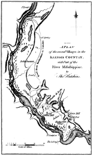
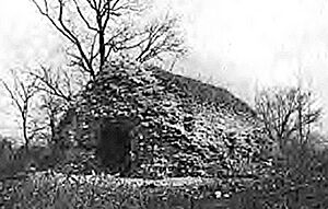
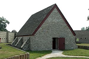
The fort's magazine, which stored ammunition, is believed to be the oldest building still standing in Illinois. Today, parts of the limestone fort have been rebuilt. The area is now an Illinois state park. You can find it about four miles (6 km) west of Prairie du Rocher in Randolph County, Illinois. The fort sits in a flat area known as the American Bottom, south of modern St. Louis.
Fort de Chartres is a very special place. It was added to the National Register of Historic Places and became a National Historic Landmark on October 15, 1966. In 1974, it was also named one of the important sites in the French Colonial Historic District. This district includes other places that show French history, like the Creole House and Fort Kaskaskia.
The fort was named after Louis, duc de Chartres. He was the son of the person who ruled France at the time. Today, the historic site hosts fun events each summer. People dress up in old clothes and act out what life was like during colonial times.
Contents
Exploring Fort de Chartres: A Look at Its Past
French Control and Early Forts
On January 1, 1718, the French government gave a company called the Company of the West the only right to trade in this area. The company hoped to find valuable metals. So, they built a fort to keep their business safe. The first fort was made of wood and was built between 1718 and 1720. French soldiers from New Orleans, led by Pierre Dugué de Boisbriant, built it.
The main office for the Illinois Country moved from Quebec City to New Orleans. This meant the fort was now managed by the Company of the Indies. The fort was meant to be the government's headquarters. It also helped control the Native American tribes in the area, especially the Meskwaki. The first fort was a fence of logs with two strong towers called bastions at opposite corners.
However, within five years, floods from the Mississippi River badly damaged the wooden fort. So, in 1725, they started building a second fort. This one was a bit further from the river but still in the flood area. This fort was also made of logs and had a bastion at each of its four corners.
The second wooden fort lasted a bit longer, but by 1742, it was also in bad shape. In 1747, the French soldiers moved to Kaskaskia, a main settlement about 18 miles (29 km) south. French leaders then discussed where to build the fort next. The government in New Orleans wanted to keep the soldiers in Kaskaskia. But the local commander wanted to rebuild the fort closer to its original spot.
Building the Stone Fortress
The government decided to build a new stone fort near the first forts, not in Kaskaskia. Construction began in 1753 and was mostly finished in 1754. This new limestone fort had walls 15 feet (4.6 m) high and 3 feet (0.9 m) thick. It covered an area of 4 acres (1.6 hectares). The stone for the fort came from cliffs about two or three miles (3.2-4.8 km) away. Workers had to ferry the stones across a small lake.
In August 1751, a man named Francois Saucier was called to New Orleans. He was given a special job: to build a new fort. This fort would hold more soldiers that France was sending. It would replace the old wooden Fort de Chartres and be made of stone. The main reasons for the new fort were to impress the Chickasaw Tribe and stop the British from moving into the area.
At first, the French government wanted the new stone fort built in Kaskaskia. But the governor, Vaudreuil, decided to keep the fort near its original spot. Because of flooding problems, they moved it a little over half a mile north of the old fort. Francois Saucier surveyed the land and made plans. He sent these plans, with costs, to the governor. After many talks and delays about the cost, a smaller version of the fort was approved. Francois and his team then started preparing the land, cutting trees, and getting ready for construction. Finally, with the budget approved, they began building the strong stone Fort de Chartres.
British Takeover and Abandonment
In 1763, the Treaty of Paris was signed. This ended the Seven Years' War (also known as the French and Indian War). France gave control of the Illinois Country east of the Mississippi River to Great Britain. Spain received the western part of the Illinois Country. The stone fort had been the center of French rule for only twenty years.
The British had trouble getting soldiers to their new fort. But on October 10, 1765, a small group of soldiers led by Captain Thomas Stirling took control of the fort. Many French Canadian settlers were told to leave or get a special permit to stay. Because of this, many French settlers moved to St. Louis, where the culture was more familiar.
The British soldiers renamed the fort Fort Cavendish. However, by 1768, it was known as Fort Chartres again. The British left the fort in May 1772. The Mississippi River continued to cause problems even after the fort was empty.
The Fort Falls to Ruin
In 1772, the south wall and a tower of the fort fell into the river. The other walls slowly crumbled. By the 1820s, visitors saw trees growing in the walls. Local people also took stones from the fort to use for their own buildings over the years. By 1900, most of the walls were gone. The only part of the original fort that remained was the stone powder magazine.
Rebuilding and Modern Day
The State of Illinois bought the ruins in 1913 to protect them as a historic site. They restored the powder magazine in 1917. This powder magazine is thought to be the oldest building still standing in Illinois. In the 1920s, the old foundations of the fort's buildings and walls were uncovered. In the late 1920s and 1930s, a government program called the WPA rebuilt the main gate and two stone buildings.
Today, there is a museum and office building on the site. It was built in 1928 on the foundation of an original fort building. Inside, you can see exhibits that show what French life was like at Fort de Chartres. The large stone "Guards House" was rebuilt in 1936. It has a Catholic chapel decorated like it would have been in the 1750s. It also has rooms for a priest, a gunner, an officer, and guards. You can also see a working bake oven and a garden shed built with old French Colonial methods. There's even a kitchen garden with plants typical of 18th-century French Illinois.
In 1989, parts of the fort's walls were rebuilt on their original foundations. The wooden frames of some other buildings were put up to show how they used to be built. The foundations and cellars of other buildings were also uncovered for people to learn from.
Today, Fort de Chartres has a museum and a small gift shop. Every June, it hosts a big event called a Rendezvous. This event is one of the largest and oldest in the country. It celebrates the French and Native American culture of the frontier.
Modern levees now protect the site from the Mississippi River. However, the river can still be a threat. During the Great Flood of 1993, the levee broke. Water rose fifteen feet deep, reaching the top of the fort's walls.
See also
- List of French forts in North America
 | James B. Knighten |
 | Azellia White |
 | Willa Brown |


