American Bottom facts for kids

The American Bottom is a flat, low-lying area next to the Mississippi River in southern Illinois. It stretches from Alton, Illinois, down to the Kaskaskia River. It is also sometimes called "American Bottoms". This area is about 453 square kilometers (175 square miles) big. Today, levees (big walls) and drainage canals help protect it from floods.
Right across the river from St. Louis, Missouri, you'll find cities and factories. But there are still many swamps and a large Horseshoe Lake. These remind us that the American Bottom was once a wild, river-side area. This plain was once the center of the Cahokia Mounds civilization, long before Europeans arrived. Later, French settlers made their homes here in the Illinois Country.
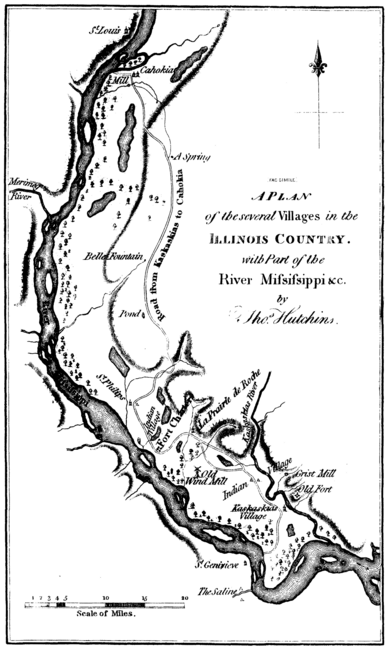
In the 1800s, many trees were cut down along the river banks to fuel steamboats. This caused big changes to the environment. The Mississippi River between St. Louis and the Ohio River became wider and shallower. Unstable banks collapsed into the water. This led to worse floods and the river changing its path. Several French towns, like Kaskaskia, Cahokia, and St. Philippe, Illinois, were destroyed. Kaskaskia had to move to a new spot.
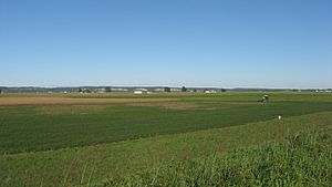
The southern part of the American Bottoms is mostly farmland. Farmers grow corn, wheat, and soybeans there. The American Bottom is also part of the Mississippi Flyway. This is a path used by many migrating birds. It has the most types of birds in Illinois. To the east, the flood plain is bordered by a long line of bluffs (cliffs). These bluffs are 60 to 90 meters (200 to 300 feet) high and about 129 kilometers (80 miles) long. Above these bluffs is the large prairie that covers most of Illinois. The Mississippi River forms the western edge of the Bottom. Parts of St. Clair, Madison, Monroe, and Randolph counties are in the American Bottom. At its widest in the north, it's about 14.5 kilometers (9 miles) across. In the south, it's usually 3 to 5 kilometers (2 to 3 miles) wide.
History
Ancient People
Before Europeans came, many different groups of native people lived here for centuries. The most advanced civilization was built by the Mississippian culture. These people are also known as the Mound Builders. After 600 CE, they learned to grow a lot of corn. This allowed them to have extra food and build large towns.
The Cahokia Mounds Site became a very important center after 1000 CE. It is a 15.5 square kilometer (six-square mile) area with huge, man-made earth mounds. These mounds rise up from the flat land. In 1982, UNESCO named Cahokia Mounds a World Heritage Site. It is one of only eight such sites in the United States.
The biggest mound is Monks Mound. It is as tall as a ten-story building. It stands in the middle of the site, facing a large plaza that covers 16 hectares (40 acres). Monks Mound is the largest ancient earthwork in North America. The whole Cahokia complex is the biggest earthwork north of Mexico. The people who built these mounds were very skilled engineers. They knew a lot about different types of soil.
Cahokia was a well-planned city with homes, farms, and workshops. Skilled workers made beautiful crafts and goods there. Because it was located where three major rivers met, Cahokia was a center for trade. Its trade network reached all the way to the Great Lakes and the Gulf Coast. At its busiest, Cahokia may have had 30,000 people. This made it the largest city north of modern-day Mexico.
Around 1300 CE, the city began to decline. This might have been because too many trees were cut down or too many animals were hunted. By 1400 CE, Cahokia was abandoned. No other city in the United States reached this population size until after 1800, when Philadelphia grew larger.
Archaeologists have studied the mounds. They found that the different types of mounds were built in a planned way. This plan showed how the Mississippians saw the world. Smaller mounds, shaped like ridges or cones, were used for special burials. Some were for important leaders, and some showed signs of sacrifices. The larger flat-topped mounds were used for temples and homes for the leaders.
Archaeologists also found traces of a 3.2 kilometer (2 mile) long wooden fence. This fence protected the main part of the city. It was rebuilt several times. They also found two large solar calendars, now called Woodhenge. These were made from cedar wood, which was considered sacred. Around the mounds, there were many "borrow pits." These were holes where soil was dug out to build the mounds and to flatten the plazas.
French Settlement
After Cahokia was abandoned, there were not many native people living in the area in the 1600s. This was when the first French explorers arrived. The French were the first Europeans to settle in this part of the Mississippi River Valley. They met native groups called the Cahokia and the Kaskaskia. The French named the earthwork complex after the Cahokia people. They named a river and a town after the Kaskaskia people.
The French built several villages. These included Kaskaskia, Cahokia, Prairie du Rocher, St. Philippe, and Prairie du Pont. You can still see examples of French buildings from the 1700s here. These include the old Cahokia courthouse and the Holy Family Catholic Church. Both were built with a special method using vertical logs, called poteaux-sur-solle.
American Settlers

American settlers started to arrive around the end of the American Revolution. At that time, Great Britain gave the Illinois Country to the new United States. In the early years, many American men came to the area. There was not much government, and it was often chaotic. As more Americans arrived, many French families moved west across the Mississippi River to St. Louis and Ste. Genevieve, Missouri. Within a few years, most people in the old French towns were Americans, and English became the main language.
The Goshen Settlement was an early American town built at the edge of the Bottom. Settlers continued to use the rich, fertile land mostly for farming until the late 1800s. Brooklyn, Illinois was founded around 1839. It was a "freedom village" for free people of color and people who had escaped slavery. "Mother" Priscilla Baltimore led this effort. It was the first town in the United States to be officially set up by African Americans under state law.
Rivers were important for travel and trade. In the 1800s, steamboats became common on the Mississippi and other big rivers. These boats needed a lot of wood for fuel. This led to many trees being cut down along the river banks. This caused big environmental problems along the Mississippi River between St. Louis and the Ohio River. With so many trees gone, the river banks became weak. The powerful current caused them to collapse into the river. In this area, the Mississippi became wider and shallower. This led to worse floods and the river changing its main path. Several French towns, like Kaskaskia, Cahokia, and St. Philippe, Illinois, were flooded and destroyed in the 1800s. Kaskaskia was rebuilt, but the Mississippi River changed its course. Now, Kaskaskia is cut off from the rest of Illinois and is connected to Missouri land.
The part of the American Bottom directly across from St. Louis became very industrial. Many factories, like steel mills, chemical plants, and oil refineries, were built here. They used coal from Illinois for power. Also, the first bridge from St. Louis across the Mississippi River charged a tax for heavy traffic. To avoid this tax, many companies simply built their factories in East St. Louis.
In the early 1900s, many factory jobs opened up in the American Bottom. This attracted many immigrants from Europe and African-American people. African Americans moved from the rural South during the Great Migration. They came to work in factories and find better lives for their children. Immigrants from Eastern Europe built the first Bulgarian Orthodox Church in the United States in Madison, Illinois. Today, East St. Louis is mostly African-American. After factories changed and jobs moved, many people whose families had immigrated moved to other areas. Heavy industry is still important here, but there are fewer jobs in these industries now.
Like the ancient Mississippians, Americans made huge changes to the flood plain. Their building and development made it harder for the land to soak up floodwaters. Wetlands were destroyed, and paved areas increased along the rivers. This has made floods worse over the years. Even with efforts to control floods, the problems have continued.
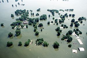
During the Great Flood of 1993, large parts of the southern Bottom were flooded. About 190 square kilometers (47,000 acres) of land below Columbia, Illinois were covered in water. The town of Valmeyer was destroyed. The water came within 1.5 meters (five feet) of overflowing the levee in East St. Louis. If it had, it would have flooded 290 square kilometers (71,000 acres) and destroyed the city and factories. In Kaskaskia, more than 2.7 meters (nine feet) of floodwater covered the town in 1993 after the levee broke. Only the top of the Catholic church and the roof of a nearby shrine could be seen above the water.
Major cities in American Bottom
 | Sharif Bey |
 | Hale Woodruff |
 | Richmond Barthé |
 | Purvis Young |


