
Cahokia, Illinois facts for kids
Quick facts for kids
Cahokia
|
|
|---|---|

Location of Cahokia in St. Clair County, Illinois.
|
|

Cahokia
Location in Illinois

Cahokia
Location in the United States
|
|
| Country | |
| State | |
| County | St. Clair |
| Area | |
| • Total | 10.31 sq mi (26.70 km2) |
| • Land | 9.75 sq mi (25.26 km2) |
| • Water | 0.56 sq mi (1.44 km2) |
| Elevation | 407 ft (124 m) |
| Population
(2020)
|
|
| • Total | 12,096 |
| • Density | 1,423.15/sq mi (549.46/km2) |
| Time zone | UTC-6 (CST) |
| • Summer (DST) | UTC-5 (CDT) |
| Area code(s) | 618 |
| FIPS code | 17-10370 |
| GNIS feature ID | 426287 |
| Wikimedia Commons | Cahokia, Illinois |
Cahokia was a village in St. Clair County, Illinois, USA. It was founded by French explorers in 1689 as a mission. The village was located on the east side of the Mississippi River. It was part of the larger Greater St. Louis area. In 2010, about 15,241 people lived there. On May 6, 2021, Cahokia became part of a new city called Cahokia Heights.
The name "Cahokia" comes from one of the clans of the Illiniwek Native American group. These people met early French explorers in the area. The famous Cahokia Mounds (a UNESCO World Heritage Site) were named after this group. However, the mounds were built by the Mississippian culture between 900 AD and 1500 AD. This was long before the French arrived. The Mississippian culture created a huge urban area here. It was the largest in their territory, which stretched across the Mississippi and Ohio river valleys.
French Canadian settlers started Cahokia village in 1696 as a Catholic mission. The Church of the Holy Family is a very old church. It is the oldest Catholic church that has been continuously active in the United States. It is also the oldest church west of the Allegheny Mountains. Other important old buildings in Cahokia include the Cahokia Courthouse (built around 1740) and the Jarrot Mansion (built around 1810). These buildings are listed on the National Register of Historic Places.
Contents
History of Cahokia
The Cahokia Mounds site, located north of the village, was named after the Illini group. However, archeologists have found that the large mounds were built by the Mississippian culture. This was an earlier group of Native Americans. Their city was at its busiest in the 13th century. It was abandoned hundreds of years before Europeans came to the area. The Cahokia Native Americans did not settle in the Illinois area until closer to the time the French arrived.
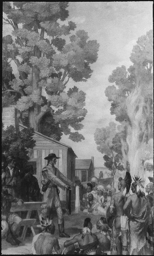
European contact with Cahokia began over 300 years ago. Father Pinet started a mission in late 1696. His goal was to teach Christianity to the Cahokian and Tamaroa Native Americans. Father Pinet and the Seminary of Foreign Missions of Quebec built a log church. It was dedicated to the Holy Family. Over the next 100 years, Cahokia grew. It became one of the biggest French colonial towns in the Illinois Country.
Cahokia became a major center for trading Native American goods and furs. The village had about 3,000 people and a busy business area. Nearby, the town of Kaskaskia on the Mississippi River became the main shipping port. Fort de Chartres became a military and government center. Farmers, known as habitants, grew wheat on the land between these cities. As the area grew, settlers and Native Americans lived together peacefully. Most settlers were Canadien families who had lived in North America for some time.
Cahokia faced difficulties after the French and Indian War in 1763. France lost this war to Great Britain. This war was part of the Seven Years' War in Europe. As a result, France had to give up large parts of the Illinois Country to the British. Many Cahokians left because they feared the British. Others wanted to live in a Catholic area. They moved to Louisiana. There, they started new Canadien villages. Examples include St. Louis and Ste. Genevieve, Missouri.
The Odawa leader Pontiac was killed by other Native Americans. This happened in or near Cahokia on April 20, 1769.
In 1778, during the American Revolutionary War, George Rogers Clark set up a court in Cahokia. This made Cahokia an independent city. However, it was still part of the Province of Quebec. Cahokia officially became part of the United States. This happened with the Treaty of Paris in 1783. Soon after, 105 Cahokia families promised loyalty to the Continental Congress of the United States.
Later, Cahokia was chosen as the county seat of St. Clair County. The Cahokia Courthouse served as a United States territorial courthouse. It was also a major political center for 24 years. In 1801, St. Clair County became larger. Henry Harrison named the Cahokia Courthouse the legal and government center for a huge area. This area reached all the way to the Canada–US border. By 1814, other counties were formed. St. Clair County became its current size. The county seat then moved to Belleville, Illinois.
Geography
Cahokia is located at 38°33′43″N 90°10′22″W / 38.561901°N 90.172878°W.
In 2010, Cahokia had a total area of about 9.9 square miles (25.6 square kilometers). About 9.4 square miles (24.3 square kilometers) of this was land. The remaining 0.5 square miles (1.3 square kilometers) was water.
Population Information
| Historical population | |||
|---|---|---|---|
| Census | Pop. | %± | |
| 1880 | 211 | — | |
| 1930 | 286 | — | |
| 1940 | 465 | 62.6% | |
| 1950 | 794 | 70.8% | |
| 1960 | 15,829 | 1,893.6% | |
| 1970 | 20,649 | 30.5% | |
| 1980 | 18,904 | −8.5% | |
| 1990 | 17,550 | −7.2% | |
| 2000 | 16,391 | −6.6% | |
| 2010 | 15,241 | −7.0% | |
| 2020 | 12,096 | −20.6% | |
| U.S. Decennial Census | |||
2020 Census Details
This table shows the different groups of people living in Cahokia village, Illinois. The US Census counts Hispanic/Latino people as an ethnic group. They are listed separately from racial categories. Hispanic/Latino people can be of any race.
| Race / Ethnicity (NH = Non-Hispanic) | Pop 2010 | Pop 2020 | % 2010 | % 2020 |
|---|---|---|---|---|
| White alone (NH) | 5,126 | 2,689 | 33.63% | 22.23% |
| Black or African American alone (NH) | 9,455 | 8,554 | 62.04% | 70.72% |
| Native American or Alaska Native alone (NH) | 30 | 43 | 0.20% | 0.36% |
| Asian alone (NH) | 29 | 10 | 0.19% | 0.08% |
| Pacific Islander alone (NH) | 2 | 6 | 0.01% | 0.05% |
| Some Other Race alone (NH) | 29 | 52 | 0.19% | 0.43% |
| Mixed Race/Multi-Racial (NH) | 272 | 457 | 1.78% | 3.78% |
| Hispanic or Latino (any race) | 298 | 285 | 1.96% | 2.36% |
| Total | 15,241 | 12,096 | 100.00% | 100.00% |
Transportation
Cahokia has the St. Louis Downtown Airport. This airport is used for general aviation, which means it handles private planes and smaller flights.
Metro operates the #2 bus route in Cahokia. This bus goes to East St. Louis, Illinois. From there, you can connect to the MetroLink light rail. The light rail can take you to St. Louis.
Education
The Cahokia Unit School District 187 runs the public schools in Cahokia.
Notable People
- Marie Josephte L'Archevêque (18th-century settler), her daughter Marie Joseph La Marche, and granddaughter Marie Josette Languedoc. Their story inspired a book called Pioneer History of Illinois.
- Terron Armstead - An NFL (National Football League) player.
- Well Hungarians – A country and rock music band.
- Michael B. Whit - A country singer and songwriter.
See also
 In Spanish: Cahokia (Illinois) para niños
