Illinois Country facts for kids
Quick facts for kids Pays des Illinois |
|||||||||||||||
|---|---|---|---|---|---|---|---|---|---|---|---|---|---|---|---|
| District of New France | |||||||||||||||
| 1675–1769 1801–1803 |
|||||||||||||||
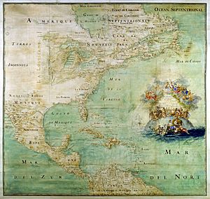
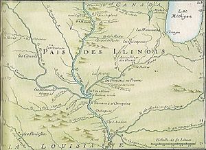 Pais (sic) des Ilinois (1717) |
|||||||||||||||
| Capital | Montreal (1675–1717) Biloxi (1717–1722) La Nouvelle-Orléans (after 1722) (**Regional: Chartres–after 1720; St Louis–after 1764) |
||||||||||||||
| History | |||||||||||||||
|
• Foundation of the first mission at the Grand Village of the Illinois
|
1675 | ||||||||||||||
|
• Transfer from French Canada to French Louisiana
|
1717 | ||||||||||||||
| 1763 | |||||||||||||||
|
• Split east to Great Britain (Province of Quebec)
|
1763 | ||||||||||||||
|
• East ceded to the United States
|
1783 | ||||||||||||||
|
• Spanish retrocession of west
|
1801 | ||||||||||||||
|
• West transferred to the United States
|
1803 | ||||||||||||||
|
|||||||||||||||
| Today part of | United States | ||||||||||||||
The Illinois Country (also known as Pays des Illinois in French) was a huge area in New France. France claimed this land in the 1600s. Today, it's part of the Midwestern United States.
The name Pays des Illinois means "Land of the Illinois people." It refers to the Illinois Confederation, a group of Native American tribes.
French settlers mainly lived along the Mississippi River and Illinois River. These areas are now in the states of Illinois and Missouri, with some outposts in Indiana.
In 1673, explorers Louis Jolliet and Jacques Marquette traveled through this region. They claimed the land for France. French settlers came here mostly for the North American fur trade and to set up Christian missions.
Until 1717, the Illinois Country was part of French Canada. Then, King Louis XV ordered it to become part of French Louisiana. This area then became known as "Upper Louisiana."
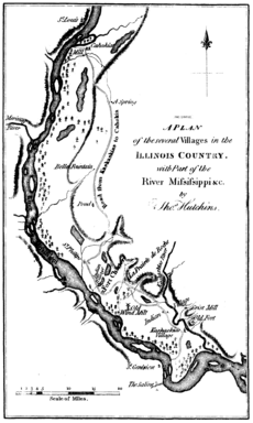
By the mid-1700s, important settlements included Cahokia, Kaskaskia, Chartres, Saint Philippe, and Prairie du Rocher. These were all on the east side of the Mississippi River in what is now Illinois. Across the river in Missouri was Ste. Genevieve. Fort Vincennes was in what is now Indiana.
After France lost the French and Indian War in 1764, the Illinois Country was divided. The land east of the Mississippi River went to the British. It became part of the British Province of Quebec. The land west of the river went to the Spanish.
During the American Revolution, an American leader named George Rogers Clark led a campaign against the British. The Illinois Country east of the Mississippi became part of Illinois County, Virginia. This county was later removed in 1782.
The name "Illinois" continued to be used for the Illinois Territory from 1809 to 1818. It became the state of Illinois in 1818. The western part of the Illinois Country was bought by the United States in the Louisiana Purchase in 1803.
Contents
Where Was the Illinois Country?
The exact borders of the Illinois Country changed over time. But the area known as the American Bottom was usually in the middle of it. The American Bottom is a rich floodplain along the Mississippi River.
One of the first places called "Illinois" was what we now call Lake Michigan. Early French explorers and traders used this name for the area around the lake. This included much of the upper Mississippi Valley.
In 1721, the seventh district of French Louisiana was named "Illinois." This district included more than half of the present-day state of Illinois. It also covered land between the Arkansas River and the 43 degrees north latitude. This stretched from the Rocky Mountains to the Mississippi River.
In 1722, a royal order gave an even broader definition. It included all French land south of the Great Lakes and north of the Ohio River. This meant the lower Missouri River Valley and both sides of the Mississippi.
Later, in 1745, the border between French Canada and French Louisiana became clearer. The governor of Louisiana set the northeastern border. It ran along the Wabash River valley up to the Vermilion River. From there, it went northwest to le Rocher on the Illinois River. Then it went west to the Rock River.
This border stayed until the Treaty of Paris (1763) in 1763. After this treaty, France gave up its land east of the Mississippi to Great Britain. Many French settlers moved west across the river to avoid British rule. The Spanish, who now controlled the west bank, still called the region governed from St. Louis the District of Illinois. They even called St. Louis the city of Illinois.
Early Explorers and Settlements
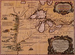
French explorers and missionaries from Canada first explored the Illinois Country in the early 1600s. Étienne Brûlé explored the upper Illinois country in 1615.
In 1669, Father Jacques Marquette, a missionary, met Native American traders from the Illinois Confederation. He learned about a great river that flowed through their land. In 1673, Marquette and Louis Jolliet explored the Mississippi River area. They traveled from Green Bay to the Arkansas River.
In 1675, Marquette returned to start a Jesuit mission at the Grand Village of the Illinois. Over the next few decades, the French built missions, trading posts, and forts. By 1714, the main European settlers were French-Canadian fur traders, missionaries, and soldiers. They traded with Native Americans, especially the Kaskaskia tribe.
The main French settlements were Kaskaskia, Cahokia, and Sainte Genevieve. By 1752, the population had grown to 2,573 people.
From the 1710s to the 1730s, the Fox Wars took place. These were conflicts between the French and their allied tribes against the Meskwaki (Fox) Native American tribe. The wars were fought over the fur trade in what is now northern Illinois, southern Wisconsin, and Michigan.
Fort St. Louis du Rocher
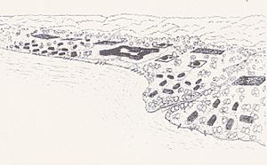
French explorers led by René-Robert Cavelier, Sieur de La Salle built Fort St. Louis in the winter of 1682. It was on a large hill called Le Rocher (The Rock) by the Illinois River. This hill gave the fort a good view over the river.
The fort had a wooden fence (palisade) for defense. Inside were a few wooden houses and Native American shelters. The French wanted Fort St. Louis to be the first of many forts. These forts would protect against English attacks and keep English settlements on the East Coast.
Native American tribes from eastern areas, like the Miami, Shawnee, and Mahican, joined the French. They settled with the Kaskaskia tribe at the base of the hill.
During the early French and Indian Wars, the French used the fort for safety. They were attacked by the Iroquois, who were allied with the British. The Iroquois forced the settlers to leave the fort in 1691. The settlers then moved to Fort Pimitoui in modern-day Peoria.
French troops occupied Fort St. Louis from 1714 to 1718. After 1718, the territory was moved from Canada to Louisiana. Fur trappers and traders used the fort for a while, but it eventually fell apart. Today, no parts of the original fort remain.
Later, on April 20, 1769, a Native American warrior killed Chief Pontiac in Cahokia. A local story says that the Ottawa and Potawatomi tribes attacked the Illini tribe. The Illini climbed the hill (Le Rocher) to hide. The Ottawa and Potawatomi kept them trapped until the Illini starved. Because of this story, Europeans called the hill Starved Rock.
Fort de Chartres
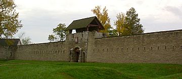
In 1718, a company called the Company of the West was given a trade monopoly. They hoped to find valuable metals in the Illinois Country. So, they sent soldiers from New Orleans to build a fort to protect their interests. Construction on the first Fort de Chartres began in 1718 and finished in 1720.
The first fort was on the east bank of the Mississippi River. It was south of Cahokia and north of Kaskaskia. The nearby town of Prairie du Rocher, Illinois was founded by French-Canadian colonists in 1722.
The fort was meant to be the government center for the Illinois Country. It also helped control the Fox Indians. The fort was named after Louis, duc de Chartres.
Because of frequent floods, a new fort was built further inland in 1725. By 1731, the Company of the Indies had closed down. They gave Louisiana and its government back to the king. The soldiers at the fort moved to Kaskaskia, Illinois in 1747.
A new stone fort was planned near the old one. It was mostly finished by 1754, but construction continued until 1760.
The new stone fort was the French headquarters for less than 20 years. It was given to the British in 1763 after the French and Indian War. The British government declared most of the land between the Appalachian Mountains and the Mississippi River as Native American territory. This was called the Indian Reserve.
Many French-Canadian settlers moved across the Mississippi River. They wanted to live in Catholic territory or avoid British rule. The British later changed their policy and extended the Province of Quebec to include the region.
The British took control of Fort de Chartres on October 10, 1765. They renamed it Fort Cavendish. The British offered the French-Canadian residents the same rights they had under French rule. In September 1768, the British set up a Court of Justice. This was the first court using common law in the Mississippi Valley. French law was called civil law.
After severe flooding in 1772, the British left the fort. They moved their soldiers to the fort at Kaskaskia and renamed it Fort Gage. The ruined but still standing magazine at Chartres is the oldest European structure in Illinois. It was rebuilt in the 20th century.
Farming and Slavery
French settlements in the Illinois Country were unique. Unlike other French settlements that had separate farms, settlers here lived together in farming villages. This was similar to villages in northern France. They practiced communal farming.
After the port of New Orleans was founded in 1718, more African slaves were brought to the Illinois Country. They worked as farm and mine laborers. By the mid-1700s, slaves made up about one-third of the population.
Other Important Settlements
- In 1675, Jacques Marquette founded the mission of the Immaculate Conception of the Blessed Virgin. It was near present-day Utica, Illinois. The Iroquois destroyed it in 1680.
- Peoria was first the southernmost part of New France. Then it became the northernmost part of French Louisiana. Finally, it was the westernmost part of the new United States. Fort Crevecoeur was founded in 1680. Another fort, often called Fort Pimiteoui, was built in 1691. French influence lasted in Peoria for over a hundred years.
- The Mission of the Guardian Angel was set up near the Chicago portage between 1696 and 1700.
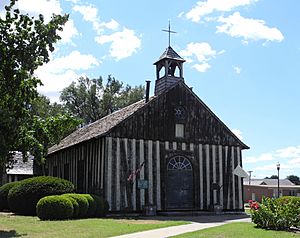
- Cahokia was founded in 1696 by French missionaries from Quebec. It was one of the earliest permanent settlements in the region. It became one of the most populated northern towns. In 1787, it became the county seat of St. Clair County in the Northwest Territory. On April 20, 1769, the great Native American leader Chief Pontiac was killed in Cahokia.
- Kaskaskia was founded in 1703 as a small French mission. It grew to become the capital of the Illinois Territory (1809–1818). It was also the first capital of the state of Illinois (1818-1820). The French built a fort here in 1721. The British destroyed it in 1763. During the American Revolutionary War, General George Rogers Clark took control of the village in 1778. The residents rang the church bell to celebrate. It became known as the "liberty bell." Flooding and a shift in the river channel in 1881 damaged the old settlement. Today, you can reach the remains of Kaskaskia only by a bridge from the Missouri side.
- In 1720, Philip Francois Renault arrived with workers and 500 African slaves from Saint-Domingue. They came to work in the mines. However, the mines only produced unprofitable coal and lead. In 1723, Renault and his workers and slaves established the village of St. Philippe. It was about 3 miles north of Fort de Chartres. This is the first record of African slaves in the region. The village quickly produced extra farm goods. These goods were sold to lower Louisiana and other less successful settlements.
- The original Ste. Genevieve was founded around 1750. It was on the western banks of the Mississippi River. The village had mostly farmers and merchants of French-Canadian background. After a great flood in 1785, the villagers moved the entire town to higher ground. The city still has many buildings with French Colonial architecture.
- The French built Fort Orleans in 1723 along the Missouri River near Brunswick, Missouri.
- Fort Vincennes, on the Wabash River, was established in 1732. The British renamed it Fort Sackville after they captured it. George Rogers Clark renamed it Fort Patrick Henry during the American Revolution.
- The French built Fort de L'Ascension on the Ohio River in 1757. It was near present-day Metropolis, Illinois.
- St. Louis was founded in 1764 by French fur traders. In 1765, it became the capital of Upper Louisiana. After 1767, Spain controlled the region west of the Mississippi. In 1780, British forces attacked St. Louis during the American Revolutionary War.
Illinois Country Under American Control
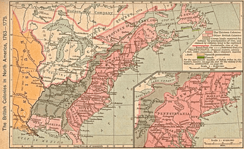
During the American Revolutionary War, General George Rogers Clark took control of the Illinois Country east of the Mississippi for Virginia. In November 1778, Virginia created the county of Illinois. This county included all the lands west of the Ohio River that Virginia claimed. Kaskaskia was the county seat.
For helping General Clark in the war, French-Canadian and Native American residents of the Illinois Country were given full citizenship. The term Illinois Country was sometimes used in laws to refer to these settlements.
Most of the Illinois Country became an organized territory of the United States in 1787. This was with the creation of the Northwest Territory. In 1803, the old Illinois Country area west of the Mississippi was gained by the U.S. in the Louisiana Purchase.
See also
 In Spanish: País de los Ilinueses para niños
 | Jackie Robinson |
 | Jack Johnson |
 | Althea Gibson |
 | Arthur Ashe |
 | Muhammad Ali |


