
Chicago Portage facts for kids


The Chicago Portage is a very special natural pathway that connects two huge water systems: the Mississippi River and the Great Lakes. Think of it as a natural bridge of land that allowed people to travel between these two important waterways. This portage, which is a place where boats are carried over land, was super important in the past.
This unique pathway cuts through a ridge of hills called the Valparaiso Moraine. It also crosses a major natural boundary called the Saint Lawrence River Divide. This divide separates rivers that flow to the Atlantic Ocean (like the St. Lawrence) from those that flow to the Gulf of Mexico (like the Mississippi). The lowest point of this pathway is right inside the city of Chicago. The Chicago Portage is a main reason why Chicago grew from a small settlement into the big, important city it is today!
The official flag of the city of Chicago even shows how important water is to its history. It has four red stars that stand for different parts of the city's past. These stars are placed between two blue stripes, which represent the waters that meet right there in Chicago.
Contents
What is a Portage?
A portage is a place where travelers had to carry their boats, like canoes, over land from one body of water to another. Imagine you're paddling down a river, and suddenly you reach a spot where the river ends or becomes too shallow. If you want to continue your journey to another river or lake, you have to get out, pick up your boat, and carry it across the land until you reach the next waterway. That's a portage!
The Chicago Portage: A Natural Connection
The Chicago Portage was a natural "water gap." This means it was a low, easy-to-cross area between two higher landforms, allowing water (or people carrying boats) to pass through. It was also sometimes a "wind-gap," meaning it was a dry valley that used to have a river flowing through it a long, long time ago. This made it a perfect spot for connecting the Great Lakes to the Mississippi River system.
How the Portage Formed
The Chicago Portage was created by powerful forces of nature, mainly huge sheets of ice called glaciers. Thousands of years ago, during the Ice Age, these glaciers moved across North America. As they melted, they left behind hills and valleys.
Glaciers and Lake Chicago
About 14,000 years ago, a giant glacier started to melt. This melting ice formed a massive lake called Lake Chicago. This ancient lake was much bigger than today's Lake Michigan. As Lake Chicago grew, its water eventually found a low spot to drain. This low spot was the Chicago Portage. The water flowed from Lake Chicago, through the portage, and into the Mississippi River system. This natural drainage path carved out the portage area we know today.
The Valparaiso Moraine
The portage cuts through a series of hills called the Valparaiso Moraine. A moraine is a ridge of rocks and dirt left behind by a glacier. The Valparaiso Moraine forms a horseshoe shape around the southern end of Lake Michigan. The Chicago Portage is like a natural doorway through this moraine, making it easy to cross.
Why the Portage Was So Important
For thousands of years, the Chicago Portage was a vital pathway for travel and trade. It connected the vast network of rivers and lakes that stretched across North America.
Early Travelers and Trade
Long before European explorers arrived, Native American tribes like the Potawatomi, Miami, and Illinois used the Chicago Portage. They traveled in canoes, carrying furs, tools, and other goods across the short land bridge. This allowed them to trade with other tribes from the Great Lakes all the way down to the Gulf of Mexico. It was like an ancient superhighway for canoes!
European Explorers and Fur Traders
When European explorers and fur traders came to North America, they quickly realized how valuable the Chicago Portage was. French explorers Louis Jolliet and Jacques Marquette were among the first Europeans to use the portage in 1673. They understood that controlling this portage meant controlling a major trade route. Fur traders used it to transport beaver pelts and other animal skins from the interior of the continent to markets in the east.
The Growth of Chicago
Because the portage was such a key location, a small settlement began to grow there. This settlement eventually became the city of Chicago. Its location at the crossroads of these two major water systems made it a perfect place for trade, transportation, and industry. The portage was the very reason Chicago became a powerful hub for shipping and business.
Building Canals to Improve the Portage
As more people moved to the area and trade grew, carrying boats over the portage became less efficient. People wanted a permanent water connection.
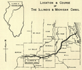
The Illinois and Michigan Canal
To make travel even easier, the Illinois and Michigan Canal was built. Construction started in 1836 and it opened in 1848. This canal was a huge engineering project that created a direct water link between the Chicago River (which connects to Lake Michigan) and the Illinois River (which flows into the Mississippi). This canal helped Chicago grow even faster, allowing steamboats and barges to move goods without having to carry them over land.
The Chicago Sanitary and Ship Canal
Later, in 1900, the Chicago Sanitary and Ship Canal was opened. This new canal was even bigger and deeper than the Illinois and Michigan Canal. It was built for two main reasons: to improve shipping and to reverse the flow of the Chicago River. Reversing the river's flow helped carry Chicago's wastewater away from Lake Michigan, which was the city's source of drinking water. This canal is still an important part of the Chicago waterway system today.
Images for kids
-
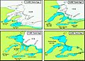
Development of the Great Lakes
-
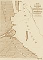
Map of ancient Lake Chicago in what became the portage region
-
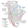
Continental Divides of North America. The pink line (center-right) denotes the Great Lakes-St Lawrence divide that runs through Chicago
-
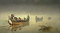
Canoes in a fog, Lake Superior by Francis Anne Hopkins
-
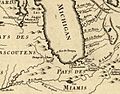
Detail from a French map (1775) showing the Chicago Portage
-
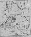
Map of Chicago Portage
-
title=


