
Illinois and Michigan Canal facts for kids
|
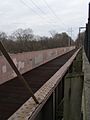
Illinois and Michigan Canal Locks and Towpath
|
|

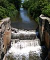
a scene at Seneca, Illinois
|
|

Location in Illinois

Location in the United States
|
|
| Nearest city | Joliet, Illinois |
|---|---|
| Area | 1,130 acres (4.6 km2) |
| Built | 1848 |
| NRHP reference No. | 66000332 |
Quick facts for kids Significant dates |
|
| Added to NRHP | October 15, 1966 |
| Designated NHL | January 29, 1964 |
The Illinois and Michigan Canal was a very important waterway. It connected the Great Lakes to the Mississippi River and the Gulf of Mexico. This canal ran for about 96 miles (154 km) in Illinois. It started in Bridgeport, Chicago, on the Chicago River. It ended at the Illinois River near LaSalle and Peru.
The canal helped Chicago become a major transportation center in the United States. This happened even before railroads became common. The canal opened in 1848. Later, a wider canal called the Chicago Sanitary and Ship Canal took over its main job in 1900. The Illinois and Michigan Canal stopped being used for transportation in 1933. This was after the Illinois Waterway was finished.
Today, parts of the canal are still preserved. Many sections are now part of the Illinois and Michigan Canal National Heritage Corridor. A group of structures and parts of the canal, from Lockport to LaSalle-Peru, were named a National Historic Landmark in 1964. This means they are very important historical sites.
Contents
Why Was the Canal Important?
In the 1800s, canals were key for moving goods and people. The Illinois and Michigan Canal linked the Mississippi River system to the Great Lakes. This connection was a big deal for trade and travel.
How the Canal Changed Illinois
The canal helped shape the northern border of Illinois. It also created strong trade and cultural links between Illinois and the Northeast. Before the canal, farmers in northern Illinois mostly grew just enough food for themselves. They didn't have easy ways to sell their crops far away. The canal changed this. It made farming in northern Illinois profitable by opening up connections to markets in the eastern U.S.
Building the Canal: A Look Back
The idea for the Illinois and Michigan Canal came from early explorers.
The First Ideas for a Canal
The first Europeans to explore this area were Father Marquette and Louis Joliet. They traveled through the Chicago Portage, which is a low, swampy area. Joliet thought that if a canal was built there, it would connect the Great Lakes to the Mississippi River. He believed this could help France create a large empire across the continent.
In 1816, Stephen Harriman Long made the first detailed survey of the portage. His measurements helped create a specific plan for the canal.
How Illinois Became a State
Nathaniel Pope and Ninian Edwards saw a chance for Illinois to become a state. They suggested moving Illinois's northern border. This would make sure the entire canal would be inside Illinois. They believed the canal would connect Illinois more strongly with the "free states" (where slavery was not allowed). Because of this, Congress allowed Illinois to become a state. This happened even though Illinois didn't have enough people yet.
Building Challenges and Workers

Construction on the canal started in 1836. However, work stopped for several years. This was due to a financial crisis in Illinois in 1837. The Canal Commission had a large grant of federal land. They sold this land to help pay for the construction. Still, they had to borrow money from investors in the eastern U.S. and Britain to finish the canal.
Most of the canal was built by Irish immigrants. Many of these workers had also helped build the Erie Canal. The work was very dangerous. Many workers died, though no official records show exactly how many. These Irish immigrants were often treated poorly by other citizens.
The canal was finished in 1848. It cost over $6 million to build. Chicago Mayor James Hutchinson Woodworth led the opening ceremony. Pumps were used to fill the canal with water near Chicago. Water from the Calumet Feeder Canal and the DuPage River also supplied the canal. In 1871, the canal was made deeper. This helped speed up the water flow and improve sewage disposal.
The Canal's Design and Use
The canal was about 60 feet (18 m) wide and 6 feet (1.8 m) deep. It had towpaths along its edges. Mules would walk on these paths to pull barges along the canal. Towns were planned along the canal's route. They were spaced out based on how far mules could pull barges in a day.
The canal had seventeen locks and four aqueducts. These structures helped barges move across the 140-foot (43 m) height difference between Lake Michigan and the Illinois River. From 1848 to 1852, the canal was a popular way for people to travel. But passenger service stopped in 1853. This was because the Chicago, Rock Island and Pacific Railroad opened, running next to the canal. The canal's busiest year for shipping was 1882. It remained in use until 1933.
The Canal's Decline and What Replaced It
After the Great Chicago Fire in 1871, Chicago rebuilt quickly. The Chicago River was very important for the city's growth. However, all waste from homes, farms, and industries was dumped into the river. This waste then flowed into Lake Michigan.
Protecting Drinking Water
_tow_downbound.jpg)
Lake Michigan was also the source of Chicago's drinking water. In 1885, a huge storm washed a lot of pollution from the river far into the lake. This was very close to the city's water intakes. To prevent future problems, the Chicago Sanitary District was created in 1889.
This new agency came up with a plan. They would build channels and canals to reverse the flow of the rivers. This would send the polluted water away from Lake Michigan. The water would instead flow downstream into the Des Plaines River and then into the Mississippi River.
In 1892, the Army Corps of Engineers reversed part of the Chicago River's flow. This meant the river and much of Chicago's sewage went into the canal instead of Lake Michigan. The river's flow was fully reversed when the Chicago Sanitary and Ship Canal opened in 1900.
The Illinois and Michigan Canal was eventually replaced in 1933 by the Illinois Waterway. This waterway is still used today.
The Canal Today: A Place for Fun and History

The original starting point of the Illinois and Michigan Canal is now a nature park. This park combines history, nature, and art. It helps people understand how important the canal was for Chicago's development. In 2003, plans were made to turn this former industrial site into a park. It now has native plants and places for quiet activities. Art students from local high schools designed interpretive panels along a bike trail.
Today, much of the canal is a long, narrow linear park. You can go canoeing there. There's also a 62.5-mile (100.6 km) hiking and biking trail. This trail was built on the old mule tow paths. The park also includes museums and historic canal buildings. In 1984, the U.S. Congress named it the first National Heritage Corridor.
Towns Along the Canal
Many towns in Northern Illinois exist because of the Illinois and Michigan Canal. Towns like Lockport, Morris, Ottawa, and LaSalle were planned by the Canal Commissioners. This helped raise money for the canal's construction. Here are some of the towns along the canal, from east to west:
- Bridgeport (a neighborhood in Chicago)
- Summit
- Willow Springs
- Lemont
- Romeoville
- Lockport
- Joliet
- Channahon
- Morris
- Seneca
- Marseilles
- Ottawa
- Utica
- LaSalle
- Peru
Important People Connected to the Canal
Several people played a role in the history of the Illinois and Michigan Canal:
- Louis Joliet
- Gurdon Saltonstall Hubbard
- Nathaniel Pope
- Ninian Edwards
- Abraham Lincoln
- John T. Stuart
Images for kids
-
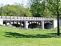
Fox River Aqueduct in Ottawa, IL
-
Aux Sable Creek Aqueduct, Morris, IL
-
Locktenders House and lock at the Aux Sable Creek
-
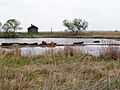
Goose Lake Prairie F&WA, Morris, IL
-
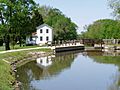
Lock #3, Lockport, IL
-
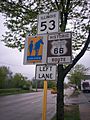
Historic Route 66, Illinois Route 53, and I&M Canal overlap in Joliet, IL
.JPG)


