
Illinois Waterway facts for kids
The Illinois Waterway is a special system of rivers, lakes, and canals in Illinois. It stretches for about 336 miles (541 km) from the Calumet River in Chicago all the way to where the Illinois River meets the Mississippi River at Grafton. This amazing waterway connects the Great Lakes to the Gulf of Mexico, allowing ships to travel huge distances across the country!
Long ago, in 1848, the Illinois and Michigan Canal (I&M) was built. Then, in 1900, the Chicago Sanitary and Ship Canal took its place. This new canal did something incredible: it made the Chicago River flow backwards, away from Lake Michigan! The United States Army Corps of Engineers helps keep the waterway working, making sure there's always a deep enough path for boats. The busy northern part of the waterway, near Chicago, is often called the Chicago Area Waterway System (CAWS).
Contents
What is the Illinois Waterway?
The Illinois Waterway is a vital link for shipping. It lets large boats, called barges, move goods between the Great Lakes and the Mississippi River system. This means products can travel from places like Chicago all the way down to the Gulf of Mexico. It's a bit like a giant watery conveyor belt!
How Does the Waterway Work?
To control the water flow and help boats move up and down, there are eight special gates called locks. The United States Army Corps of Engineers manages these locks. The first lock, called T.J. O'Brien, is near Lake Michigan. The last one, LaGrange, is about 90 miles (145 km) from the Mississippi River.
Sometimes, people disagree about how much water should be let into the Illinois Waterway from Lake Michigan. If the lake levels are high, people near the lake want to let more water out. But if lake levels are low, they want to keep more water in. Because Lake Michigan's water eventually flows into other Great Lakes like Huron, Erie, and Ontario, Canada also cares about its levels. That's why an international agreement helps decide how much water can be released.
Moving Goods on the Waterway
Many different kinds of goods travel on the Illinois Waterway. Big ships carry things like coal, chemicals, and oil. They also transport farm products such as corn and soybeans. This makes the waterway very important for moving goods across the country.
Winter Challenges
During some winters, the waterway can get very cold. Ice can form, especially around the locks and dams. When this happens, it can stop boats from moving. This means shipping sometimes has to pause until the ice clears.
The Locks and Dams
The Illinois Waterway has eight locks and dams that help boats travel up and down the river. These structures are like giant steps for boats. They raise or lower the water level so boats can pass safely. Each lock helps the waterway drop a certain amount of feet as it gets closer to the Mississippi River.
Understanding the Waterway's Drop
The Illinois Waterway starts high up, about 578 feet (176 meters) above sea level near Lake Michigan. By the time it reaches the Mississippi River at Grafton, it's much lower, around 419 feet (128 meters) above sea level. The eight locks and dams along the way are what make this big drop possible. They allow boats to slowly go down (or up) the different levels of the waterway.

Images for kids
-
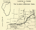
Historical Map of canal structure, later construction would create the Illinois Waterway
-
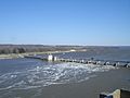
The Illinois Waterway at Starved Rock Lock and Dam
-
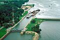
Starved Rock Lock and Dam on the Illinois Waterway
-
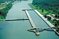
T. J. O’Brien Lock and Dam on the Calumet River, which is part of the Illinois Waterway. The dam is located in Chicago.


