Romeoville, Illinois facts for kids
Quick facts for kids
Romeoville, Illinois
|
|||
|---|---|---|---|

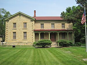
Fitzpatrick House (1842), on the grounds of Lewis University
|
|||
|
|||
| Nickname(s):
"Stone City"
|
|||
| Motto(s):
Where Community Matters!
|
|||

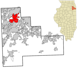
Location of Romeoville in Will County, Illinois
|
|||
| Country | United States | ||
| State | Illinois | ||
| County | Will | ||
| Township | DuPage, Lockport, Plainfield, Wheatland | ||
| Incorporated | January 19, 1895 | ||
| Area | |||
| • Total | 20.16 sq mi (52.21 km2) | ||
| • Land | 19.13 sq mi (49.55 km2) | ||
| • Water | 1.03 sq mi (2.67 km2) | ||
| Elevation | 630 ft (190 m) | ||
| Population
(2020)
|
|||
| • Total | 39,863 | ||
| • Density | 2,083.80/sq mi (804.58/km2) | ||
| Time zone | UTC−6 (CST) | ||
| • Summer (DST) | UTC−5 (CDT) | ||
| ZIP Code(s) |
60446, 60491
|
||
| Area codes | 815/779 and 630/331 | ||
| FIPS code | 17-65442 | ||
| GNIS feature ID | 2399114 | ||
| Website | http://www.romeoville.org/ | ||
Romeoville is a village in Will County, Illinois, United States. It is located about 26 miles (42 km) southwest of Chicago. The village sits near the Gateway Wetlands, west of the Des Plaines River. In 2020, Romeoville had a population of 39,863 people. It is part of the Chicago suburban area, close to Interstate 55 and Interstate 355.
Contents
History of Romeoville
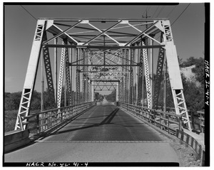
Romeoville was one of the last places in Will County where Native Americans lived. The area was first settled on September 14, 1835. This happened on Isle a La Cache, a small island in the Des Plaines River. Around this time, the first bridge was built to reach the island from the west side of the river.
In 1848, the I&M Canal was finished. This brought many new people to the area. On January 19, 1895, the people of Romeo voted to become an official village. They also changed the village's name to Romeoville.
The community, along with nearby Joliet, became known as "Stone City." This name came from its successful limestone quarries. Limestone is a type of rock used in building. The Illinois State Capitol building in Springfield, finished in 1888, is made entirely of Romeoville limestone. Lewis University was started on the edge of town in 1934.
Romeoville is home to Citgo's Lemont Refinery. This refinery was built in 1922 across the river from the village.
In 1950, Romeoville had only about 46 homes and 147 people. The village stayed small until 1957. Then, over 600 acres (240 ha) of wetlands near IL-53 became the Hampton Park Subdivision. Another 400 acres (160 ha) were added in 1964. Romeoville's population slowly grew.
On October 5, 1990, the first exit on I-55 at Weber Road was built. This connected the village to the rest of the Chicagoland. Over the next ten years, the area along Weber Road quickly grew with new housing. Romeoville was one of the fastest-growing communities in Illinois during the 1990s and 2000s. The population grew very fast, with over 25,000 new residents in two decades.
Geography and Climate
Romeoville covers about 18.76 square miles (48.59 km2). Most of this area, about 98.3%, is land. The other 1.7% is water. Romeoville shares borders with several nearby towns. These include Bolingbrook, Plainfield, Crystal Lawns, Crest Hill, Lockport, and Lemont.
Weather in Romeoville
Romeoville has a National Weather Service forecast office. This office helps predict the weather for the area.
Population Information
| Historical population | |||
|---|---|---|---|
| Census | Pop. | %± | |
| 1900 | 113 | — | |
| 1910 | 98 | −13.3% | |
| 1920 | 74 | −24.5% | |
| 1930 | 133 | 79.7% | |
| 1940 | 170 | 27.8% | |
| 1950 | 147 | −13.5% | |
| 1960 | 3,574 | 2,331.3% | |
| 1970 | 12,888 | 260.6% | |
| 1980 | 15,519 | 20.4% | |
| 1990 | 14,074 | −9.3% | |
| 2000 | 21,153 | 50.3% | |
| 2010 | 39,680 | 87.6% | |
| 2020 | 39,863 | 0.5% | |
| U.S. Decennial Census 2010 2020 |
|||
How Romeoville's Population Has Changed
The table below shows the different groups of people living in Romeoville. It also shows how these groups changed between 2010 and 2020.
| Race / Ethnicity (NH = Non-Hispanic) | Pop 2010 | Pop 2020 | % 2010 | % 2020 |
|---|---|---|---|---|
| White alone (NH) | 19,992 | 16,654 | 50.38% | 41.78% |
| Black or African American alone (NH) | 4,545 | 5,362 | 11.45% | 13.45% |
| Native American or Alaska Native alone (NH) | 61 | 32 | 0.15% | 0.08% |
| Asian alone (NH) | 2,486 | 2,718 | 6.27% | 6.82% |
| Pacific Islander alone (NH) | 3 | 2 | 0.01% | 0.01% |
| Some Other Race alone (NH) | 53 | 121 | 0.13% | 0.30% |
| Mixed Race or Multi-Racial (NH) | 657 | 1,166 | 1.66% | 2.93% |
| Hispanic or Latino (any race) | 11,883 | 13,808 | 29.95% | 34.64% |
| Total | 39,680 | 39,863 | 100.00% | 100.00% |
Economy and Jobs

Romeoville is home to more than 600 businesses. In 2013, the village won a Gold Medal award. This was for creating 1,560 jobs between 2012 and 2013. This was the most jobs created for a town of its size.
Major Employers in Romeoville
Here are some of the biggest employers in the village:
| # | Employer | # of Employees |
|---|---|---|
| 1 | Amazon | 1,824 |
| 2 | Valley View School District 365U | 1,300 |
| 3 | Green Core | 1,200 |
| 4 | PDV Midwest Refining CITGO | 803 |
| 5 | Aryzta | 600 |
| 6 | Ulta Beauty | 543 |
| 7 | Walmart | 537 |
| 8 | RTC | 530 |
| 9 | Magid Glove and Safety | 529 |
| 10 | Lewis University | 525 |
Other important employers include Kehe Foods, FedEx Ground, and the Village of Romeoville itself.
Education in Romeoville
Schools for Kids and Teens
Students in Romeoville attend schools in different districts:
- Valley View School District 365U
- Valley View Early Childhood Center
- Beverly Skoff Elementary School
- Irene King Elementary School
- Kenneth L. Hermansen Elementary School
- Robert C. Hill Elementary School
- A. Vito Martinez Middle School
- John J. Lukancic Middle School
- Romeoville High School
- St. Andrew the Apostle School
- Plainfield Community Consolidated School District 202
- Eichelberger Elementary School
- Creekside Elementary School
- Lakewood Falls Elementary School
- John F Kennedy Middle School
- Indian Trails Middle School
- Plainfield East High School
- Lockport Township High School District 205
- Lockport Township High School
Colleges and Universities
For higher education, Romeoville has these options:
- Joliet Junior College – Romeoville Campus
- Rasmussen College – Romeoville Campus
- Lewis University – Main Campus
Transportation and Roads
Romeoville has several ways to get around:
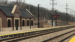
- Train: The Metra station is on the Heritage Corridor line.
- Airport: Lewis University Airport handles aircraft from small planes to business jets.
- Bus: Pace bus route 834 serves the area.
Main Highways in Romeoville
Important highways that pass through Romeoville include:
|
US Highways |
Famous People from Romeoville
Here are some notable people who have connections to Romeoville:
- Gerald Coleman: A goalie who played ice hockey for the Lake Erie Monsters and Tampa Bay Lightning.
- Egotistico Fantastico: A professional wrestler.
- Oliver Gibson: A defensive tackle who played football for the Pittsburgh Steelers and the Cincinnati Bengals.
- Sandra Navarro Gillette: A singer who had a worldwide hit song in 1994. She graduated from Romeoville High School.
- Antonio Morrison: A linebacker who played football for the Indianapolis Colts and Green Bay Packers.
- Byron Stingily: An offensive tackle who played football for the Tennessee Titans and Pittsburgh Steelers.
See also
 In Spanish: Romeoville (Illinois) para niños
 | Ernest Everett Just |
 | Mary Jackson |
 | Emmett Chappelle |
 | Marie Maynard Daly |


