Valparaiso Moraine facts for kids
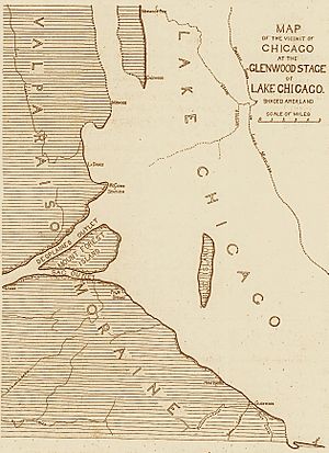
The Valparaiso Moraine is a huge, U-shaped ridge of hills that wraps around the bottom of Lake Michigan in North America. Think of it like a giant, hilly wall made of dirt, rocks, and sand left behind by a glacier. It starts near the border of Wisconsin and Illinois. From there, it goes south through several counties in Illinois, then turns southeast into Indiana. In Indiana, it curves northeast through Lake, Porter, and LaPorte counties, and then continues into Michigan all the way to Montcalm County.

This amazing landform was created during a time called the Crown Point Phase of the Wisconsin glaciation. This was a period when a huge sheet of ice (a glacier) covered much of the area. As the glacier started to melt and shrink, it left behind a lot of material like dirt, sand, and rocks. This material piled up where the glacier stopped, forming the hills we now call the Valparaiso Moraine. After this moraine formed, the glacier moved back even more, creating another ridge called the Tinley Moraine.
Many towns in northwest Indiana and northeast Illinois are named after the Valparaiso Moraine or the Tinley Moraine. Also, many small rivers and creeks begin in the Valparaiso Moraine. The moraine itself was named after the city of Valparaiso, Indiana. This is because the moraine is narrower and taller there than in other places.
The Valparaiso Moraine is also part of something called the Saint Lawrence River Divide. This means it acts like a giant natural wall that separates where water flows. Water on one side of the moraine flows into Lake Michigan, then through the Great Lakes, and finally into the Atlantic Ocean through the Saint Lawrence River. But water on the other side flows into rivers that lead to the Mississippi River, which eventually empties into the Gulf of Mexico.
Contents
How the Valparaiso Moraine Formed
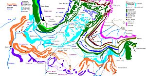
The Valparaiso Moraine was the first big ridge of hills to form during the Cary substage of the Wisconsin Glacial period. This period was about 10,000 to 50,000 years ago. In northeastern Illinois, there are three smaller moraines that formed around the same time: the Minooka, Rockdale, and Manhattan moraines.
Inside the big curve of the Valparaiso Moraine, two younger moraines formed later. These are the Tinley Moraine and the Lake Border Moraine. Even younger is the Port Huron system, which is found in the northern part of the Lake Michigan area. The Cary substage, when the Valparaiso Moraine formed, dates back to around 30,000 years ago.
Where is the Valparaiso Moraine?

The Valparaiso system includes five moraines north of Chicago. Its most northern point reaches the start of the Fox River in Waukesha County, west of Milwaukee. The moraine then angles south and east. It reaches the start of the Des Plaines River west of Kenosha, Wisconsin.
The moraine forms a large part of the eastern edge of the Fox River Basin. It then becomes the western bank of the Des Plaines River. The moraine continues south along the Des Plaines River. It follows the path of the modern Tri-State Tollway (I-294) around the west side of Chicago. Where the Des Plaines River turns west to form the Illinois River, the moraine angles south and east. It keeps going along I-294 towards Chicago Heights. In this area, the moraine has gotten wider towards the south and east. It becomes a broad, flat area covering large parts of Will and Kankakee counties.
Turning eastward, the moraine enters Indiana. It is about 17 kilometers (11 miles) wide as it goes through Lake County, Indiana. It covers almost half of the middle part of the county. As it passes through Porter County, Indiana, it goes under the city of Valparaiso. This is where it gets its name. Through Indiana, the moraine creates a "continental divide." This means it separates the water that flows into the Great Lakes from the water that flows into the Gulf of Mexico through the Mississippi River.
The moraine then turns northeast. It passes just north of La Porte, Indiana, through the county of the same name. When it enters Michigan, the moraine forms much of the shoreline of Lake Michigan. It goes northward through St. Joseph. From here northward, the moraine angles more eastward. It misses Holland and passes through Grand Rapids. It finally ends where it mixes with other moraines about 50 kilometers (31 miles) northwest of Grand Rapids in Montcalm County.
Size and Shape of the Moraine
The inner edge of the moraine is less than 15 kilometers (9 miles) from Lake Michigan. At its closest point, it is only about 6 kilometers (4 miles) away. The entire moraine system is from 5 to 6 kilometers (3 to 4 miles) wide, up to almost 20 kilometers (12 miles) wide. It is narrowest in LaPorte County, Indiana and widest in Lake County, Indiana. In northern Illinois, different parts of the moraine join together.
The Valparaiso moraine system in Michigan includes the hilly belt along Lake Michigan. This part goes south from the Grand River Valley. In some places, it has two or more ridges. These ridges often join together and then separate again. In northern Van Buren County, it connects with the Saginaw moraine.
How High is the Moraine?
The moraine usually sits between 198 meters (650 feet) and 210 meters (690 feet) above sea level. This means it is about 21 meters (70 feet) to 33 meters (110 feet) higher than the surface of Lake Michigan. From the inner edge of the moraine, the ground usually rises 30 meters (100 feet) or more. In some spots, it rises 60 meters (200 feet) or even more.
The highest points in Illinois are about 228 meters (750 feet) to 274 meters (900 feet) above sea level. The very highest point is near Lake Zurich, in southern Lake County. The lowest point is on the Des Plaines River, in Will County. In Indiana, the highest points range from 228 meters (750 feet) in Lake County to almost 274 meters (900 feet) in LaPorte County.
The Michigan part of the moraine is 204 meters (670 feet) to 244 meters (800 feet) high near the St. Joseph River. This height continues north to the border of Allegan and Van Buren counties. In Allegan County, the moraine has the biggest changes in height. The highest point there is 274 meters (900 feet). The lowest point, near the Kalamazoo River, is a little above 213 meters (700 feet).
Protecting the Moraine Today
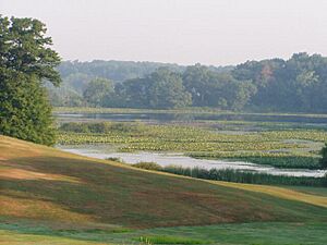
Moraine Nature Preserve is a special place located north of Valparaiso, Indiana. It is east of State Route 49 and south of US Route 6 on County Road 750 North (Meska Rd). The Indiana Department of Natural Resources takes care of this area, which is about 327 hectares (809 acres) in size.
The preserve has many trails that wind through rolling ridges and steep hills. These hills were left behind by the glaciers. The area also includes round holes in the ground called potholes and a shallow pond. The higher ground is covered by a mature beech-maple forest. In the ravines, potholes, and near the pond, you can find plants like buttonbush and black willow.
Similar Moraines in Other Areas
The Lake Erie basin has two moraines that formed at the same time as the Valparaiso Moraine. These are the Mississinewa Moraine and the Union Moraine. They were created by the Lake Erie Lobe of the huge continental glacier. In Michigan, the Kalamazoo Moraine also formed during the same time period. This moraine was created by the Saginaw lobe of the Laurentian glacier.
 | Janet Taylor Pickett |
 | Synthia Saint James |
 | Howardena Pindell |
 | Faith Ringgold |


