Kalamazoo River facts for kids
Quick facts for kids Kalamazoo River |
|
|---|---|

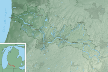
Map of the Kalamazoo River watershed
|
|
| Physical characteristics | |
| Main source | South Branch : Near North Adams 41°59′05″N 84°30′59″W / 41.98476°N 84.51633°W North Branch: Near Farewell and Pine Hills lakes, Jackson County 42°05′47″N 84°28′38″W / 42.09643°N 84.47717°W |
| River mouth | Lake Michigan 42°40′36″N 86°12′55″W / 42.67669°N 86.21531°W |
| Length | 130 miles (210 km) |
| Basin features | |
| Basin size | 5,230 km2 (2,020 sq mi) |
The Kalamazoo River is an important river in the state of Michigan in the United States. It flows for about 130 miles (209 km) from where its two main branches meet, all the way to Lake Michigan. If you include its longest branch, the South Branch, the river is actually about 178 miles (286 km) long!
The river's watershed is a large area of about 2,020 square miles (5,230 km²). This area collects all the rain and snowmelt that eventually flows into the river. It covers parts of eight counties in southwest Michigan, including Allegan, Kalamazoo, and Jackson counties.
The Kalamazoo River starts with two main parts, called branches. The South Branch begins near North Adams. It flows north and west, joining the North Branch in Albion. The North Branch starts near Farewell and Pine Hills lakes in southern Jackson County. It flows north and west before meeting the South Branch in Albion.
After Albion, the Kalamazoo River flows mostly west. It passes through towns like Marshall, Battle Creek, and Kalamazoo. From Kalamazoo, the river turns north. It then flows northwest through Allegan and Saugatuck before finally emptying into Lake Michigan.
Many smaller rivers and creeks flow into the Kalamazoo River. Some of the larger ones are Rice Creek, Wilder Creek, Battle Creek River, Portage Creek, Gun River, and Rabbit River.
Contents
History of the Kalamazoo River

People have lived near and used the Kalamazoo River for over 11,000 years. When Europeans first arrived, Potawatomi tribes were the main inhabitants of the area. A French priest, Father Jacques Marquette, might have been the first European to see the river's mouth in 1675.
Later, in the late 1700s, fur traders often visited the area. By the early 1800s, small towns like Kalamazoo began to grow along the river. However, once railroads were built in the 1840s, the river became less important for travel and moving goods.
River Use and Pollution
In the mid-1800s, towns like Battle Creek, Kalamazoo, and Plainwell grew into busy centers. Many factories and businesses started here after the Civil War. These included companies making cereal, medicines, and car parts.
Several towns became known for making paper. These paper mills used water from the river and also put their waste into it. Old ways of removing ink from paper caused harmful chemicals called PCBs to get into the river. Other waste from factories and sewage also polluted the water.
For many years, from the 1940s to the 1960s, the river was very dirty. People often tried to avoid it.
Cleaning Up the River
Starting in the 1970s, with a new law called the federal Clean Water Act, serious efforts began to clean up the Kalamazoo River. Today, the river is much cleaner. However, some PCB pollution still remains. Because of this, a 35-mile (56 km) section of the river from Kalamazoo to Allegan Dam is a Superfund site. This means it's a place that needs a special, long-term cleanup effort.
Many types of fish live in the river, like smallmouth bass, largemouth bass, catfish, and carp. Fish populations have grown because the river is cleaner. But it is still advised not to eat too much fish from the Kalamazoo River. Pregnant women are told not to eat any fish from the river. This is because some fish, especially those that feed near the bottom, can still have small amounts of pollution in them.
Changes at the River's Start
In the late 1950s, a dam was built at the start of the North Branch, near Farwell and Pinehill Lakes. This dam raised the water level of the lakes. This caused soil to wash into the lakes, making them less clear. People living around Farwell Lake have been working hard to make the lake clean again. They have added a sewer system and teach people about keeping chemicals out of the water. They hope the dam will be removed so the river can flow naturally again.
Meaning of Kalamazoo
The name "Kalamazoo" comes from Native American languages. However, its exact meaning is not fully known. There are different ideas about what the name means. You can find more details about these ideas in the article about the Etymology of Kalamazoo.
Kalamazoo River Oil Spill
On July 26, 2010, an Enbridge Energy pipeline broke. It leaked over 1 million gallons (3,785 m³) of a type of oil called tar sands, also known as dilbit, into Talmadge Creek. This creek flows into the Kalamazoo River.
At first, two homes had to be evacuated, and people were told not to fish or swim. The US Environmental Protection Agency (EPA) later said the spill was even larger than first thought. A few days later, more homes were evacuated, and many people were told not to drink their tap water. The National Transportation Safety Board said this oil spill was the most expensive onshore cleanup in U.S. history.
Dams on the Kalamazoo River
Many dams have been built along the Kalamazoo River over the years. Some of these dams are still used to make electricity, while others are no longer active. The Plainwell Dam, for example, was removed in 2009.
| Name | Height | Purpose(s) | Capacity (MW) | Year Built | Owner name | Reservoir name | Coordinates | Comments |
|---|---|---|---|---|---|---|---|---|
| Lake Allegan (Calkins Bridge) | 33 ft (10.1 m) | Hydroelectric | 2.5 | 1930 | Consumers Energy | Lake Allegan | 42°33′49″N 85°57′13″W / 42.56369°N 85.9536°W | |
| Allegan City | 12 ft (3.7 m) | Retired hydroelectric | 1900 | City of Allegan | 42°31′30″N 85°50′45″W / 42.52493°N 85.84576°W | |||
| Trowbridge | 11 ft (3.4 m) | Retired hydroelectric | 1899 | Michigan DNR | 42°28′58″N 85°47′47″W / 42.4828°N 85.7964°W | |||
| Otsego | 5 ft (1.5 m) | Retired hydroelectric | 1904 | Michigan DNR | 42°27′54″N 85°44′59″W / 42.46492°N 85.74965°W | Also known as Otsego Township Dam. Removed 2015-2016 and replaced by a temporary structure, which itself was removed in 2018. | ||
| Otsego City | 9 ft (2.7 m) | Retired hydroelectric | 1886 | City of Otsego | 42°27′48″N 85°41′32″W / 42.4632°N 85.6923°W | |||
| Morrow | 14 ft (4.3 m) | Hydroelectric | .9 | 1941 | STS Hydropower | Morrow Lake | 42°16′57″N 85°29′30″W / 42.2826°N 85.4918°W | |
| Monroe Street | 12 ft (3.7 m) | Retired hydroelectric | 1894 | City of Battle Creek | Lower Mill Pond | 42°18′46″N 85°11′07″W / 42.3128°N 85.18531°W | ||
| Ceresco | 15 ft (4.6 m) | Retired hydroelectric | 1906 | 42°16′12″N 85°03′39″W / 42.27001°N 85.06081°W | Dam has been removed | |||
| Marshall | 14 ft (4.3 m) | Hydroelectric | 0.319 | 1890 | City of Marshall | 42°15′46″N 84°57′15″W / 42.26269°N 84.95421°W | ||
| Albion | 7 ft (2.1 m) | Retired hydroelectric | 1856 | City of Albion | 42°14′21″N 84°44′58″W / 42.23911°N 84.7494°W | |||
| Concord | 9 ft (2.7 m) | Recreation | 1830 | 42°10′49″N 84°38′47″W / 42.18038°N 84.64627°W | ||||
| Total | 3.72 |
See also
 In Spanish: Río Kalamazoo para niños
 | Emma Amos |
 | Edward Mitchell Bannister |
 | Larry D. Alexander |
 | Ernie Barnes |


