Kalamazoo County, Michigan facts for kids
Quick facts for kids
Kalamazoo County
|
|
|---|---|

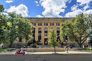
Kalamazoo County Courthouse
|
|

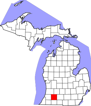
Location within the U.S. state of Michigan
|
|
 Michigan's location within the U.S. |
|
| Country | |
| State | |
| Founded | May 7, 1830 |
| Seat | Kalamazoo |
| Largest city | Kalamazoo |
| Area | |
| • Total | 580 sq mi (1,500 km2) |
| • Land | 562 sq mi (1,460 km2) |
| • Water | 19 sq mi (50 km2) 3.2%% |
| Population
(2020)
|
|
| • Total | 261,670 |
| • Density | 446/sq mi (172/km2) |
| Time zone | UTC−5 (Eastern) |
| • Summer (DST) | UTC−4 (EDT) |
| Congressional districts | 4th, 5th |
Kalamazoo County is a county in the state of Michigan, USA. It's a place where many people live and work. In 2020, about 261,670 people called Kalamazoo County home. The main city and government center, known as the county seat, is Kalamazoo.
Kalamazoo County is also part of a larger area called the Kalamazoo–Portage Metropolitan Statistical Area. This means it's connected to nearby cities like Portage.
Contents
History
Kalamazoo County was officially created in 1830. The village of Kalamazoo, which was once called Bronson, became the county seat in 1831. This means it was chosen as the main place for the county's government.
The name "Kalamazoo" is thought to come from an old Native American name, "Kikalamazoo." It might mean "the mirage or reflecting river." You can learn more about where the name comes from in the article Etymology of Kalamazoo. Kalamazoo County does not have its own special flag.
Geography
Kalamazoo County covers a total area of about 580 square miles. Most of this area, about 562 square miles, is land. The remaining 19 square miles (about 3.2%) is water, like rivers and lakes.
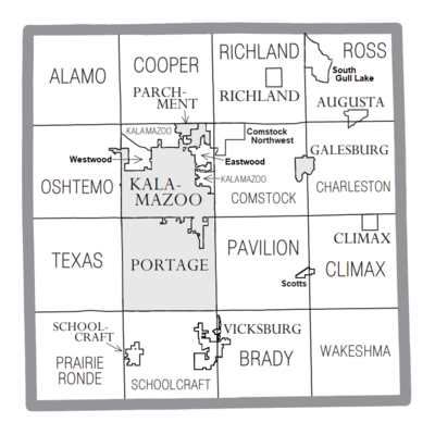
Geographic features
Adjacent counties
Kalamazoo County shares its borders with several other counties. These are its neighbors:
- Barry County – to the northeast
- Allegan County – to the northwest
- Calhoun County – to the east
- Van Buren County – to the west
- Branch County – to the southeast
- St. Joseph County – to the south
- Cass County – to the southwest
Transportation
Getting around Kalamazoo County is easy thanks to different ways to travel.
Transit
- Kalamazoo Metro Transit provides bus services for people to get around the area.
- The Kalamazoo station is a train station, connecting the county to other places by rail.
Air service
- For air travel, the Kalamazoo/Battle Creek International Airport serves the Kalamazoo and Battle Creek area.
Highways
Many important roads, called highways, run through Kalamazoo County:
 I-94 goes from east to west through the middle of the county.
 BS I-94 is a business route connected to I-94.
 US 131 runs north to south through the western part of the county.


 Bus. US 131 connects northern Kalamazoo to US 131.
 M-43 enters the county from the west and runs eastward.
 M-89 enters from the north and goes southeast.
 M-96 starts in eastern Kalamazoo and heads east.
- M-343 starts in northeast Kalamazoo and follows Gull Road.
Demographics
| Historical population | |||
|---|---|---|---|
| Census | Pop. | %± | |
| 1840 | 7,380 | — | |
| 1850 | 13,179 | 78.6% | |
| 1860 | 24,646 | 87.0% | |
| 1870 | 32,054 | 30.1% | |
| 1880 | 34,342 | 7.1% | |
| 1890 | 39,273 | 14.4% | |
| 1900 | 44,310 | 12.8% | |
| 1910 | 60,327 | 36.1% | |
| 1920 | 71,225 | 18.1% | |
| 1930 | 91,368 | 28.3% | |
| 1940 | 100,085 | 9.5% | |
| 1950 | 126,707 | 26.6% | |
| 1960 | 169,712 | 33.9% | |
| 1970 | 201,550 | 18.8% | |
| 1980 | 212,378 | 5.4% | |
| 1990 | 223,411 | 5.2% | |
| 2000 | 238,603 | 6.8% | |
| 2010 | 250,331 | 4.9% | |
| 2020 | 261,670 | 4.5% | |
| 2023 (est.) | 262,215 | 4.7% | |
| U.S. Decennial Census 1790–1960 1900–1990 1990–2000 2010–2019 |
|||
The population of Kalamazoo County has grown a lot over the years. In 1840, there were about 7,380 people. By 2020, the population had grown to 261,670 people. This shows how the county has developed and attracted more residents over time.
In 2010, about 250,331 people lived in the county. Most people were White, and there were also many Black or African American, Asian, and Native American residents. About 4% of the population identified as Hispanic or Latino.
The average age in the county in 2000 was 33 years old. About 24% of the population was under 18 years old.
Communities
Kalamazoo County is made up of many different cities, villages, and townships. Each of these communities has its own unique character.
Cities
Villages
Charter townships
- Comstock Charter Township
- Cooper Charter Township
- Kalamazoo Charter Township
- Oshtemo Charter Township
- Texas Charter Township
Civil townships
- Alamo Township
- Brady Township
- Charleston Township
- Climax Township
- Pavilion Township
- Prairie Ronde Township
- Richland Township
- Ross Township
- Schoolcraft Township
- Wakeshma Township
Census-designated places
These are areas that are like towns but are not officially incorporated as cities or villages.
Other unincorporated communities
These are smaller places that are not officially cities, villages, or census-designated places.
- Adams Park
- Alamo
- Collins Corner
- Comstock
- Cooks Mill
- Cooper
- Doughertys Corners
- East Comstock
- East Cooper
- Factoryville
- Fulton
- Gardners Corners
- Gull Lake
- Highland Park
- Howlandsburg
- Lakewood
- Lawndale
- Lemon Park
- Midland Park
- Milwood
- Northwood
- Oakwood
- Pavilion
- Pavillion Center
- Pomeroy
- Ramona Park
- Richland Junction
- Texas Corners
- Yorkville
See also
 In Spanish: Condado de Kalamazoo para niños
 | Laphonza Butler |
 | Daisy Bates |
 | Elizabeth Piper Ensley |


