St. Joseph County, Michigan facts for kids
Quick facts for kids
Saint Joseph County
|
||
|---|---|---|

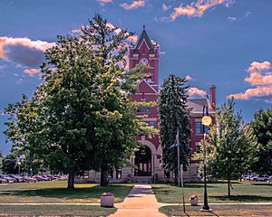
St. Joseph County Courthouse in Centreville
|
||
|
||

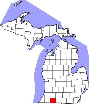
Location within the U.S. state of Michigan
|
||
 Michigan's location within the U.S. |
||
| Country | ||
| State | ||
| Founded | 1829 | |
| Named for | Fort St. Joseph | |
| Seat | Centreville | |
| Largest city | Sturgis | |
| Area | ||
| • Total | 521 sq mi (1,350 km2) | |
| • Land | 501 sq mi (1,300 km2) | |
| • Water | 20 sq mi (50 km2) 3.9%% | |
| Population
(2020)
|
||
| • Total | 60,939 | |
| • Density | 122/sq mi (47/km2) | |
| Time zone | UTC−5 (Eastern) | |
| • Summer (DST) | UTC−4 (EDT) | |
| Congressional district | 6th | |
St. Joseph County is a county in the state of Michigan. It's located on Michigan's southern border with Indiana. In 2020, about 60,939 people lived here. The main town, or county seat, is Centreville.
French explorers first came to this area in the late 1600s. They named the St. Joseph River after Saint Joseph, a patron saint of New France. This land became part of the United States after the American Revolutionary War. In 1821, a special agreement called the 1821 Treaty of Chicago was signed. This treaty gave a lot of land from local Native American tribes to the United States. This opened the area for new settlers. The county was officially created in 1829 and was named after the river.
St. Joseph County is also home to Michigan's oldest and largest Amish community.
Contents
History of St. Joseph County
Long ago, this area was home to three Native American tribes. They were the Potawatomi, Odawa, and Chippewa (also called Ojibwa). These tribes spoke similar languages and were part of the Council of Three Fires.
In 1679, French explorers, led by Father Hennepin, traveled up the St. Joseph River from Lake Michigan. A Jesuit mission was later built near where the French would build Fort St. Joseph. They named the river "St. Joseph."
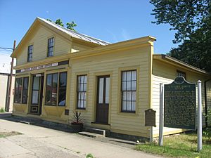
After the 1821 Treaty of Chicago, more land became available for settlers. People came from places like Detroit and Monroe. Some also came from New England and New York. The first European settlers were French. Two brothers from Detroit, the Godfroys, set up a trading post. They traded with the Native Americans of the Nottawaseepe settlement. Another trading post was nearby. Patrick Marantette, also from Detroit, worked there. He later married Frances Mouton's daughter, Francis. Their wedding was the first in the settlement. Their daughter, born in 1836, was the first European American baby born there.
Geography and Nature
St. Joseph County covers about 521 square miles. Most of this (501 square miles) is land, and about 20 square miles (3.9%) is water. It is the fourth smallest county in Michigan by total area. All the water in the county flows into the Saint Joseph River.
Neighboring Counties
St. Joseph County shares borders with several other counties:
- Van Buren County to the northwest
- Kalamazoo County to the north
- Calhoun County to the northeast
- Branch County to the east
- LaGrange County, Indiana to the south
- Elkhart County, Indiana to the southwest
- Cass County to the west
Main Roads and Highways
Several important roads run through St. Joseph County:
 US 12 goes east to west through the southern part of the county. It passes through White Pigeon and Sturgis.
 US 131 goes north to south through the western part. It passes through Three Rivers, Constantine, and White Pigeon.
 M-60 runs east-northeast through the northern part. It passes through Three Rivers, Parkville, Mendon, and Leonidas.
 M-66 comes into the southeastern part from Indiana. It goes north to meet M-60 near Mendon.
 M-86 goes east to west through the middle of the county. It passes through Colon, Nella, and Centreville, ending at M-60 in Three Rivers.
People and Population
The population of St. Joseph County has changed over the years. In 2010, the county had 61,295 people. This was a small decrease from the year 2000.
In 2010, there were 23,244 households and 16,275 families. A household is a group of people living together. A family is a group of people related by blood, marriage, or adoption. The average household had 2.60 people. The average family had 3.08 people.
About 25.9% of the people were under 18 years old. About 14.9% were 65 years or older. The average age in the county was 39 years.
The median income for a household in 2010 was about $43,964. The median income for a family was about $52,600. This means half of the households earned more than this amount, and half earned less.
Towns and Villages
St. Joseph County has several cities, villages, and smaller communities.
Cities in St. Joseph County
Villages in St. Joseph County
- Burr Oak
- Centreville (This is the county seat, where the main county government offices are.)
- Colon
- Constantine
- Mendon
- White Pigeon
Other Communities (Unincorporated)
These are smaller places that are not officially cities or villages:
Townships in St. Joseph County
A township is a type of local government area, often covering rural parts of a county.
- Burr Oak Township
- Colon Township
- Constantine Township
- Fabius Township
- Fawn River Township
- Florence Township
- Flowerfield Township
- Leonidas Township
- Lockport Township
- Mendon Township
- Mottville Township
- Nottawa Township
- Park Township
- Sherman Township
- Sturgis Township
- White Pigeon Township
See also
 In Spanish: Condado de St. Joseph (Míchigan) para niños
 | Selma Burke |
 | Pauline Powell Burns |
 | Frederick J. Brown |
 | Robert Blackburn |


