LaGrange County, Indiana facts for kids
Quick facts for kids
LaGrange County
|
|
|---|---|

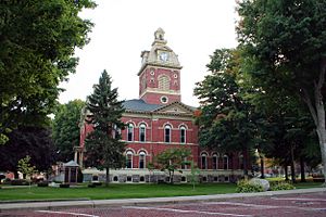
LaGrange County courthouse in LaGrange, Indiana. Built in the 1870s, it is now on the National Register of Historic Places.
|
|

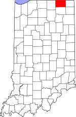
Location within the U.S. state of Indiana
|
|
 Indiana's location within the U.S. |
|
| Country | |
| State | |
| Founded | 1832 |
| Named for | Château de la Grange-Bléneau |
| Seat | LaGrange |
| Largest city | LaGrange |
| Area | |
| • Total | 386.70 sq mi (1,001.5 km2) |
| • Land | 379.62 sq mi (983.2 km2) |
| • Water | 7.08 sq mi (18.3 km2) 1.83%% |
| Population
(2020)
|
|
| • Total | 40,446 |
| • Estimate
(2023)
|
40,907 |
| • Density | 104.5927/sq mi (40.3835/km2) |
| Time zone | UTC−5 (Eastern) |
| • Summer (DST) | UTC−4 (EDT) |
| Congressional district | 3rd |
| Indiana county number 44 | |
LaGrange County is a county in Indiana, a state in the United States. In 2020, about 40,446 people lived here. The main town, or county seat, is LaGrange, Indiana.
The county is in Northern Indiana, a region called Michiana. It is about 55 miles (89 km) east of South Bend. It is also 105 miles (169 km) west of Toledo, Ohio and 175 miles (282 km) northeast of Indianapolis.
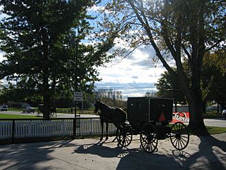
LaGrange County is famous for its large Amish population. About half of the people in LaGrange County are Amish. It has the third-largest Amish community in the U.S. This community is part of the Elkhart-LaGrange Amish affiliation. The county works with nearby Elkhart County to promote tourism. They call the area "Northern Indiana Amish Country."
Contents
History of LaGrange County
The first settlement in LaGrange County began in 1828. It was located near a place now called Lima. Over the next four years, more settlers moved into the area.
In 1832, LaGrange County was officially created. It was formed from parts of Elkhart County. Lima was chosen as the first county seat.
Later, in 1836, the town of LaGrange was planned out. It was settled in 1842 and became the new county seat. This new location was closer to the center of the county. The town of Lima was later renamed Howe in 1909.
Early Settlers of LaGrange County
Many of the first settlers in LaGrange County were from New England. They were often called "Yankees." These families came from places like Massachusetts, Connecticut, and Vermont. They were part of a large movement of people heading west. This movement happened after the Erie Canal was finished.
When these settlers arrived, the area was mostly wild forest and open prairie. They worked hard to clear land for farms and build roads. They also built churches and government buildings. Their efforts helped shape LaGrange County's early culture.
Amish Community Growth
In 1837, the government moved the Potawatomi Tribe from the county's northwest corner. Chief Shipshewana, a leader of the tribe, was later allowed to return. He died in Newbury Township in 1841.
A town called Georgetown was planned in 1837 but was not developed. In 1844, the first Amish families arrived from Pennsylvania. They settled around this old town site. The area continued to grow. The town of Shipshewana was planned nearby in 1899. It became an official town in 1916.
Naming LaGrange County
LaGrange County was named after a special place in France. It was named after the Château de la Grange-Bléneau. This was the home of Gilbert du Motier, Marquis de La Fayette. He was a French hero who helped America during the American Revolutionary War. The château is located outside of Paris, France.
Geography of LaGrange County
LaGrange County covers a total area of about 386.70 square miles (1,001.5 km2). Most of this area, about 379.62 square miles (983.2 km2), is land. The remaining 7.08 square miles (18.3 km2) is water.
The county's landscape is mostly rural farmland. It also has some gently rolling hills and several lakes.
Neighboring Counties
LaGrange County shares borders with several other counties:
- St. Joseph County, Michigan (northwest)
- Branch County, Michigan (northeast)
- Steuben County (east)
- Noble County (south)
- Elkhart County (west)
Main Roads


 I-80 / I-90 / Indiana Toll Road
Climate and Weather in LaGrange
| Weather chart for LaGrange, Indiana | |||||||||||||||||||||||||||||||||||||||||||||||
|---|---|---|---|---|---|---|---|---|---|---|---|---|---|---|---|---|---|---|---|---|---|---|---|---|---|---|---|---|---|---|---|---|---|---|---|---|---|---|---|---|---|---|---|---|---|---|---|
| J | F | M | A | M | J | J | A | S | O | N | D | ||||||||||||||||||||||||||||||||||||
|
1.8
29
14
|
1.8
34
16
|
2.7
45
25
|
3.3
57
36
|
3.6
69
47
|
4.2
79
57
|
3.6
82
61
|
4
80
59
|
3.5
73
51
|
2.8
61
40
|
2.9
47
31
|
2.6
34
20
|
||||||||||||||||||||||||||||||||||||
| temperatures in °F precipitation totals in inches source: The Weather Channel |
|||||||||||||||||||||||||||||||||||||||||||||||
|
Metric conversion
|
|||||||||||||||||||||||||||||||||||||||||||||||
In LaGrange, the average temperature in January is about 14°F (-10°C). In July, the average high is about 82°F (28°C). The lowest temperature ever recorded was -28°F (-33°C) in December 2000. The highest was 104°F (40°C) in June 1988.
The amount of rain and snow changes throughout the year. February usually gets about 1.76 inches (4.5 cm) of precipitation. June gets the most, with about 4.17 inches (10.6 cm).
Population and People
| Historical population | |||
|---|---|---|---|
| Census | Pop. | %± | |
| 1840 | 3,664 | — | |
| 1850 | 8,387 | 128.9% | |
| 1860 | 11,366 | 35.5% | |
| 1870 | 14,148 | 24.5% | |
| 1880 | 15,630 | 10.5% | |
| 1890 | 15,615 | −0.1% | |
| 1900 | 15,284 | −2.1% | |
| 1910 | 15,148 | −0.9% | |
| 1920 | 14,009 | −7.5% | |
| 1930 | 13,780 | −1.6% | |
| 1940 | 14,352 | 4.2% | |
| 1950 | 15,347 | 6.9% | |
| 1960 | 17,380 | 13.2% | |
| 1970 | 20,890 | 20.2% | |
| 1980 | 25,550 | 22.3% | |
| 1990 | 29,477 | 15.4% | |
| 2000 | 34,909 | 18.4% | |
| 2010 | 37,128 | 6.4% | |
| 2020 | 40,446 | 8.9% | |
| 2023 (est.) | 40,907 | 10.2% | |
| U.S. Decennial Census 1790–1960 1900–1990 1990–2000 2010–2013 2020 |
|||
In 2020, LaGrange County had a population of 40,446 people. The population has been growing steadily over the years.
Amish Community in LaGrange County

About 43% of the people in LaGrange County are Amish. This makes it home to the third-largest Amish community in the United States. This community is part of the Elkhart-LaGrange Amish affiliation.
Because of the large Amish population, many people in the county speak German or Pennsylvania German at home. In 2000, about 28.45% of the population reported speaking these languages. About 68.5% of the total population spoke English at home.
According to the LaGrange County Commissioners in 2020, the number of Amish and non-Amish people is almost equal. The county's population grew by nearly 9% between 2010 and 2020. This growth was mainly due to the increasing Amish population.
Religious Groups in LaGrange County
Religion in LaGrange County, according to ARDA (2020) Anabaptist Churches (Amish) (44.7%) Evangelical Churches (7.8%) Mainline Protestant Churches (5.2%) Catholic Church (2.3%) Black Protestant Churches (0.7%) None (39.8%)
Based on data from 2020, the largest religious group in LaGrange County is Anabaptist Churches, which includes the Amish. They make up about 44.7% of the population. Other groups include Evangelical Churches (7.8%) and Mainline Protestant Churches (5.2%). The Catholic Church accounts for 2.3% of the population.
Communities in LaGrange County
LaGrange County has several towns and many smaller communities.
Towns
- LaGrange
- Shipshewana
- Topeka
- Wolcottville (partially in Noble County)
Townships
- Bloomfield
- Clay
- Clearspring
- Eden
- Greenfield
- Johnson
- Lima
- Milford
- Newbury
- Springfield
- Van Buren
Census-Designated Place
Other Communities
- Brighton
- Brushy Prairie
- Eddy
- Elmira
- Emma
- Gravel Beach
- Greenfield Mills
- Greenwood
- Hartzel
- Honeyville
- Indianola
- Lakeside Park
- Lakeview
- Mongo
- Mount Pisgah
- Northwood
- Oak Lodge
- Ontario
- Pashan
- Plato
- Ramblewood
- River Oaks
- Scott
- Seyberts
- Sha-Get Acres
- Shady Nook
- South Milford
- Star Mill
- Stony Creek
- Stroh
- Tall Timbers
- Timberhurst
- Twin Lakes
- Valentine
- Webers Landing
- Witmer Manor
- Woodland Hills
- Woodland Park
- Woodruff
Economy of LaGrange County
The economy in LaGrange County is mostly based on farming. There are also many small shops. Tourism is also very important, especially in the town of Shipshewana.
Education in LaGrange County

LaGrange County has three public school districts.
Public Schools
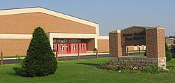
The Lakeland School Corporation serves the central part of the county. This system includes Lakeland Primary (grades K-2), Lakeland Intermediate (grades 3-6), and Lakeland Jr/Sr High (grades 7-12).
The Prairie Heights School Corporation serves the eastern side of the county. It also includes parts of Steuben County. The school mascot for Prairie Heights is a black panther.
The Westview School Corporation serves the western part of the county. This system has four elementary schools: Meadowview, Shipshewana-Scott, Topeka, and Westview. It also has one junior-senior high school called Westview.
Private Schools
Many Amish schools are located throughout LaGrange County. These are private schools that serve the Amish community.
Public Library
The LaGrange County Public Library serves the county. It has branches in LaGrange, Shipshewana, and Topeka.
See also
 In Spanish: Condado de LaGrange para niños
 | John T. Biggers |
 | Thomas Blackshear |
 | Mark Bradford |
 | Beverly Buchanan |

