Steuben County, Indiana facts for kids
Quick facts for kids
Steuben County
|
|
|---|---|
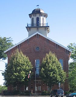
Steuben County Courthouse in Angola (on the National Register of Historic Places).
|
|
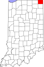
Location within the U.S. state of Indiana
|
|
 Indiana's location within the U.S. |
|
| Country | |
| State | |
| Founded | February 5, 1836 (authorized) 1837 (organized) |
| Named for | Baron Frederick von Steuben |
| Seat | Angola |
| Largest city | Angola |
| Area | |
| • Total | 322.47 sq mi (835.2 km2) |
| • Land | 308.94 sq mi (800.2 km2) |
| • Water | 13.53 sq mi (35.0 km2) 4.20%% |
| Population
(2020)
|
|
| • Total | 34,435 |
| • Estimate
(2023)
|
34,917 |
| • Density | 106.785/sq mi (41.2300/km2) |
| Time zone | UTC−5 (Eastern) |
| • Summer (DST) | UTC−4 (EDT) |
| Congressional district | 3rd |
| Website | https://www.co.steuben.in.us/ Official County Website] |
| Indiana county number 76 | |
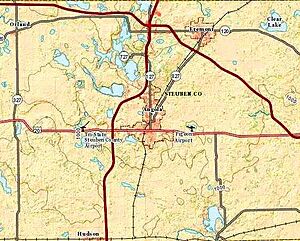
Steuben County is a county located in the very northeast corner of the U.S. state of Indiana. It's known for its many lakes and beautiful natural areas. In 2020, about 34,435 people lived here. The main town and county seat is Angola. Steuben County is part of the Angola, IN Micropolitan Statistical Area, which means it's a smaller city area that's important for its region.
Contents
History of Steuben County
After the American Revolutionary War, the United States gained control of the land that would become Indiana. In 1787, this area was part of the Northwest Territory. Later, in 1800, it became the Indiana Territory.
The land where Steuben County is today was once home to the Potawatomi people. They were a Native American tribe that lived in many small groups. Over time, through agreements and treaties, the United States gained control of their lands. The land that is now Steuben County was acquired by the U.S. in 1826 through the Treaty of Mississinewas.
The Indiana State Legislature officially created Steuben County on February 7, 1835. The county was then formally set up in 1837. It was named after Baron Frederick von Steuben, a brave officer who helped the American army during the Revolutionary War. Around 1840, many Potawatomi people were moved from this area to new lands in Kansas.
Geography and Nature
Steuben County has gentle, rolling hills. Many of these areas have been made flat for farming, but you can still find wooded areas, especially near rivers and lakes. The highest point in the county is a small hill about 1,200 feet above sea level, located east of Glen Eden.
The county is famous for its many lakes, with 105 lakes of different sizes! Some of the biggest and most popular lakes include Lake James, Lake George, Clear Lake, Jimmerson Lake, Lake Gage, and Crooked Lake. There's also a state park here called Pokagon State Park, which is a great place to explore nature.
Steuben County covers about 322.47 square miles in total. Most of this (about 308.94 square miles) is land, and the rest (about 13.53 square miles) is water.
Neighboring Areas
Steuben County is unique because it touches two other states: Michigan and Ohio!
- Branch County, Michigan - to the north
- Hillsdale County, Michigan - to the northeast
- Williams County, Ohio - to the east
- DeKalb County - to the south
- Noble County - to the southwest
- LaGrange County - to the west
Main Roads
Many important roads run through Steuben County, making it easy to travel around.


 Indiana Toll Road (Interstate 80 and Interstate 90)
 Interstate 69
 U.S. Route 20
 State Road 1
 State Road 120
 State Road 127
 State Road 327
 State Road 427
 State Road 827
Cities and Towns
Steuben County has one city and several towns where people live.
Small Communities
There are also many smaller, unincorporated communities in the county.
- Alvarado
- Berlien
- Clarks Landing
- Cold Springs
- Courtney Corner
- Crooked Lake
- Ellis
- Flint
- Forest Park
- Fountain Park
- Glen Eden
- Helmer
- Indian Hills
- Inverness
- Island Park
- Jamestown
- Lake James
- Lakeside Park
- Meadow Shores Park
- Metz
- Moonlight
- Nevada Mills
- Oakwood
- Otsego Center
- Page
- Panama
- Penn Park
- Pleasant Lake
- Ravinia Oaks
- Ray
- Russels Point
- Salem Center
- Steubenville
- Turkey Creek
- Westview
- Wildwood
- York
Townships
The county is divided into smaller areas called townships.
- Clear Lake
- Fremont
- Jackson
- Jamestown
- Millgrove
- Otsego
- Pleasant
- Richland
- Salem
- Scott
- Steuben
- York
Nature Preserves
Steuben County also has protected natural areas.
- Cedar Lake Wetlands Conservation Area
- Marsh Lake Wetlands State Fish and Wildlife Area
- Pokagon State Park
Climate and Weather
| Weather chart for Angola, Indiana | |||||||||||||||||||||||||||||||||||||||||||||||
|---|---|---|---|---|---|---|---|---|---|---|---|---|---|---|---|---|---|---|---|---|---|---|---|---|---|---|---|---|---|---|---|---|---|---|---|---|---|---|---|---|---|---|---|---|---|---|---|
| J | F | M | A | M | J | J | A | S | O | N | D | ||||||||||||||||||||||||||||||||||||
|
2
29
14
|
1.8
33
16
|
2.9
44
25
|
3.4
57
35
|
3.9
69
47
|
3.9
78
57
|
3.7
82
60
|
4.1
80
58
|
3.3
73
50
|
2.6
60
39
|
3.1
46
30
|
2.8
34
20
|
||||||||||||||||||||||||||||||||||||
| temperatures in °F precipitation totals in inches source: The Weather Channel |
|||||||||||||||||||||||||||||||||||||||||||||||
|
Metric conversion
|
|||||||||||||||||||||||||||||||||||||||||||||||
The weather in Angola, the county seat, changes throughout the year. In January, the average low temperature is about 14°F, and in July, the average high is about 82°F. The county gets a good amount of rain and snow, with August usually being the wettest month.
Population Information
| Historical population | |||
|---|---|---|---|
| Census | Pop. | %± | |
| 1840 | 2,578 | — | |
| 1850 | 6,104 | 136.8% | |
| 1860 | 10,374 | 70.0% | |
| 1870 | 12,854 | 23.9% | |
| 1880 | 14,645 | 13.9% | |
| 1890 | 14,478 | −1.1% | |
| 1900 | 15,219 | 5.1% | |
| 1910 | 14,274 | −6.2% | |
| 1920 | 13,360 | −6.4% | |
| 1930 | 13,386 | 0.2% | |
| 1940 | 13,740 | 2.6% | |
| 1950 | 17,087 | 24.4% | |
| 1960 | 17,184 | 0.6% | |
| 1970 | 20,159 | 17.3% | |
| 1980 | 24,694 | 22.5% | |
| 1990 | 27,446 | 11.1% | |
| 2000 | 33,214 | 21.0% | |
| 2010 | 34,185 | 2.9% | |
| 2020 | 34,435 | 0.7% | |
| 2023 (est.) | 34,917 | 2.1% | |
| US Decennial Census 1790-1960 1900-1990 1990-2000 2010 |
|||
In 2010, there were 34,185 people living in Steuben County. Most people (about 96.8%) were white. About 2.9% of the population was of Hispanic or Latino background. The average age of people in the county was about 40.2 years old.
Education
Colleges and Universities
- Trine University
School Districts
Students in Steuben County attend schools in several different districts.
- Fremont Community Schools
- Hamilton Community Schools
- M S D of Steuben County
- Prairie Heights Community School Corporation
Famous People from Steuben County
- Edgar "Pop" Buell (1913–1980) was a humanitarian aid worker. He helped people in Laos in the 1960s and 1970s. He was born and farmed in Richland Township before starting his aid work.
See also
 In Spanish: Condado de Steuben (Indiana) para niños
 | Laphonza Butler |
 | Daisy Bates |
 | Elizabeth Piper Ensley |


