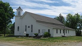
Ray, Indiana and Michigan facts for kids
Quick facts for kids
Ray, Indiana and Michigan
|
|
|---|---|

Ray Community Church in Indiana
|
|
| Country | United States |
| States | Indiana and Michigan |
| Counties | Steuben (IN) Branch (MI) |
| Elevation | 1,079 ft (329 m) |
| Time zone | UTC-5 (Eastern (EST)) |
| • Summer (DST) | UTC-4 (EDT) |
| ZIP code(s) | |
| Area code(s) | 260 (Indiana) 517 (Michigan) |
| GNIS feature ID | 635676 |
Ray is a small community that sits right on the border between two U.S. states: Indiana and Michigan! It's what we call an unincorporated community. This means it's a group of homes and businesses that isn't officially a city or town with its own local government.
This unique community is located along a road called "State Line Road." A railroad, the Indiana Northeastern Railroad, also travels through Ray. The area is quite high up, with an elevation of 1,079 feet (329 meters). This makes it the highest populated place in northern Indiana.
Ray in Indiana
The Indiana part of Ray is located in the northeastern section of Fremont Township. This is in the northeastern part of Steuben County.
Nearby towns in Indiana include Clear Lake to the southeast and Fremont to the southwest. There used to be a lake called Cedar Lake southwest of Ray, but now it's mostly a marshy area. Ray once had its own post office, which operated from 1872 to 1960. Today, people living in the Indiana part of Ray get their mail from the Fremont, IN 46737 post office.
Ray in Michigan
The Michigan part of Ray is found in the very southeastern corner of Branch County. It's located where Delmar Road meets State Line Road, on the southern edge of California Township.
Other communities close to the Michigan side of Ray include California directly to the north. Quincy is also almost directly north. To the east-northeast, you'll find Montgomery. The city of Coldwater, which is the main city and government center for Branch County, is located to the northwest.
 | Valerie Thomas |
 | Frederick McKinley Jones |
 | George Edward Alcorn Jr. |
 | Thomas Mensah |


