DeKalb County, Indiana facts for kids
Quick facts for kids
DeKalb County
|
|
|---|---|

|
|

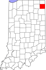
Location within the U.S. state of Indiana
|
|
 Indiana's location within the U.S. |
|
| Country | |
| State | |
| Founded | February 7, 1835 (authorized) 1837 (organized) |
| Named for | Johann, Baron de Kalb |
| Seat | Auburn |
| Largest city | Auburn |
| Area | |
| • Total | 363.85 sq mi (942.4 km2) |
| • Land | 362.82 sq mi (939.7 km2) |
| • Water | 1.03 sq mi (2.7 km2) 0.28%% |
| Population
(2020)
|
|
| • Total | 43,265 |
| • Estimate
(2023)
|
44,198 |
| • Density | 118.9089/sq mi (45.9110/km2) |
| Time zone | UTC−5 (Eastern) |
| • Summer (DST) | UTC−4 (EDT) |
| Congressional district | 3rd |
| Website | DeKalb County Government |
| Indiana county number 17 | |
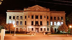
DeKalb County is a county located in the state of Indiana, United States. It's like a special district within the state. In 2020, about 43,265 people lived here. The main town and center of the county government is Auburn.
Contents
A Look Back: History of DeKalb County
DeKalb County was officially created on February 7, 1835. This happened when the Indiana State Legislature passed a big law that set up thirteen new counties in northeast Indiana. The county's government started working in 1837.
The county is named after General Johann de Kalb. He was a brave officer from Bavaria (a region in Germany) who fought for the American side during the American Revolutionary War. He sadly died in a battle in South Carolina.
The first people to settle in what would become DeKalb County came from New England. They were often called "Yankees" and were descendants of English Puritans. Later, in the 1870s, many immigrants from Ireland and Germany also came to live in DeKalb County.
Where is DeKalb County? Geography
DeKalb County is on the eastern side of Indiana. Its eastern border touches the western border of Ohio. The land here is mostly flat or gently rolling, and it's used for farms or towns.
The highest point in the county is about 1,060 feet (323 meters) above sea level. This small hill is in the northwest part of the county, near Fairfield Center. The Saint Joseph River flows through the southeastern part of the county. Cedar Creek drains the western part.
According to the 2010 census, DeKalb County covers about 363.85 square miles (942.4 square kilometers). Most of this area, about 362.82 square miles (939.7 square kilometers), is land. Only a small part, about 1.03 square miles (2.7 square kilometers), is water.
Neighboring Counties
DeKalb County shares borders with these other counties:
- LaGrange County - to the northwest
- Steuben County - to the north
- Williams County, Ohio - to the northeast
- Defiance County, Ohio - to the southeast
- Allen County - to the south
- Noble County - to the west
Cities and Towns in DeKalb County
Here are the main cities and towns you'll find in DeKalb County:
- Altona
- Ashley
- Auburn (This is the county seat, where the government offices are)
- Butler
- Corunna
- Garrett
- Hamilton
- Saint Joe
- Waterloo
Small Communities (Unincorporated)
These are smaller places that aren't officially cities or towns:
- Auburn Junction
- Butler Center
- Cedar
- Concord
- Fairfield Center
- Hopewell
- Moore
- Newville
- Orangeville
- Saint Johns
- Sedan
- Spencerville
- Summit
County Townships
DeKalb County is divided into smaller areas called townships:
- Butler
- Concord
- Fairfield
- Franklin
- Grant
- Jackson
- Keyser
- Newville
- Richland
- Smithfield
- Spencer
- Stafford
- Troy
- Union
- Wilmington
Main Roads and Highways
These are the major roads that help people travel through DeKalb County:
 Interstate 69
 U.S. Route 6
 State Road 1
 State Road 3
 State Road 4
 State Road 8
 State Road 101
 State Road 205
 State Road 327
 State Road 427
Weather in DeKalb County
| Weather chart for Auburn, Indiana | |||||||||||||||||||||||||||||||||||||||||||||||
|---|---|---|---|---|---|---|---|---|---|---|---|---|---|---|---|---|---|---|---|---|---|---|---|---|---|---|---|---|---|---|---|---|---|---|---|---|---|---|---|---|---|---|---|---|---|---|---|
| J | F | M | A | M | J | J | A | S | O | N | D | ||||||||||||||||||||||||||||||||||||
|
1.8
31
17
|
1.4
36
20
|
2.6
48
29
|
3.4
61
39
|
3.7
72
49
|
4.2
81
58
|
3.7
84
62
|
2.8
82
60
|
3.6
75
54
|
2.7
63
43
|
3.2
49
34
|
2.5
37
23
|
||||||||||||||||||||||||||||||||||||
| temperatures in °F precipitation totals in inches source: The Weather Channel |
|||||||||||||||||||||||||||||||||||||||||||||||
|
Metric conversion
|
|||||||||||||||||||||||||||||||||||||||||||||||
The weather in Auburn, the county seat, changes a lot throughout the year. In January, the average low temperature is about 17°F (-8°C). In July, the average high temperature is about 84°F (29°C).
The coldest temperature ever recorded was -24°F (-31°C) in January 1984. The hottest was 106°F (41°C) in June 1988. The county usually gets the most rain in June, and the least in February.
Who Lives Here? Demographics
| Historical population | |||
|---|---|---|---|
| Census | Pop. | %± | |
| 1840 | 1,968 | — | |
| 1850 | 8,251 | 319.3% | |
| 1860 | 13,880 | 68.2% | |
| 1870 | 17,167 | 23.7% | |
| 1880 | 20,225 | 17.8% | |
| 1890 | 24,307 | 20.2% | |
| 1900 | 25,711 | 5.8% | |
| 1910 | 25,054 | −2.6% | |
| 1920 | 25,600 | 2.2% | |
| 1930 | 24,911 | −2.7% | |
| 1940 | 24,756 | −0.6% | |
| 1950 | 26,023 | 5.1% | |
| 1960 | 28,271 | 8.6% | |
| 1970 | 30,837 | 9.1% | |
| 1980 | 33,606 | 9.0% | |
| 1990 | 35,324 | 5.1% | |
| 2000 | 40,285 | 14.0% | |
| 2010 | 42,223 | 4.8% | |
| 2020 | 43,265 | 2.5% | |
| 2023 (est.) | 44,198 | 4.7% | |
| US Decennial Census 1790-1960 1900-1990 1990-2000 2010-2014 |
|||
In 2010, there were 42,223 people living in DeKalb County. Most people (about 96.9%) were white. Smaller groups included Asian, Black or African American, and American Indian people. About 2.4% of the population was of Hispanic or Latino background.
Many people in DeKalb County have German (36.3%), American (10.9%), Irish (10.8%), or English (9.1%) family backgrounds.
The average age of people in the county was about 38.1 years old. About 35.2% of homes had children under 18 living there. Most families (54.8%) were married couples.
Learning in DeKalb County: Education
School Districts
Students in DeKalb County attend schools in these districts:
- DeKalb County Central United School District
- DeKalb County Eastern Community School District
- Garrett-Keyser-Butler Community School District
- Hamilton Community Schools
Private Schools
There are also private schools available:
- Lakewood Park Christian School
- St. Joseph's Catholic School (in Garrett)
- Trinity Lutheran Church Preschool
- Zion Lutheran Pre-School (in Garrett)
See also
 In Spanish: Condado de DeKalb (Indiana) para niños
 | Anna J. Cooper |
 | Mary McLeod Bethune |
 | Lillie Mae Bradford |

