Williams County, Ohio facts for kids
Quick facts for kids
Williams County
|
|||
|---|---|---|---|

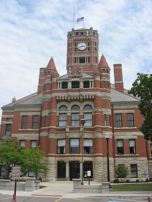
Williams County Courthouse in Bryan
|
|||
|
|||

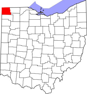
Location within the U.S. state of Ohio
|
|||
 Ohio's location within the U.S. |
|||
| Country | |||
| State | |||
| Founded | February 2, 1824 | ||
| Named for | David Williams | ||
| Seat | Bryan | ||
| Largest city | Bryan | ||
| Area | |||
| • Total | 423 sq mi (1,100 km2) | ||
| • Land | 421 sq mi (1,090 km2) | ||
| • Water | 2.1 sq mi (5 km2) 0.5% | ||
| Population
(2020)
|
|||
| • Total | 37,102 |
||
| • Density | 88/sq mi (34/km2) | ||
| Time zone | UTC−5 (Eastern) | ||
| • Summer (DST) | UTC−4 (EDT) | ||
| Congressional district | 9th | ||
Williams County is a county located in the U.S. state of Ohio. As of the 2020 census, about 37,102 people live here. The main town, or county seat, is Bryan.
The county was first created in 1820 and officially started in 1824. It is named after David Williams. He was a soldier in the American Revolutionary War and helped capture a British spy.
Contents
Geography
Williams County covers a total area of about 423 square miles. Most of this area, about 421 square miles, is land. The rest, about 2.1 square miles, is water.
Neighboring Counties
Williams County shares borders with several other counties and states:
- Hillsdale County, Michigan (to the north)
- Fulton County (to the east)
- Henry County (to the southeast)
- Defiance County (to the south)
- DeKalb County, Indiana (to the southwest)
- Steuben County, Indiana (to the northwest)
Population History
The population of Williams County has changed over many years. Here is a look at how many people have lived here during different census years.
| Historical population | |||
|---|---|---|---|
| Census | Pop. | %± | |
| 1830 | 387 | — | |
| 1840 | 4,465 | 1,053.7% | |
| 1850 | 8,018 | 79.6% | |
| 1860 | 16,633 | 107.4% | |
| 1870 | 20,991 | 26.2% | |
| 1880 | 23,821 | 13.5% | |
| 1890 | 24,897 | 4.5% | |
| 1900 | 24,953 | 0.2% | |
| 1910 | 25,198 | 1.0% | |
| 1920 | 24,627 | −2.3% | |
| 1930 | 24,316 | −1.3% | |
| 1940 | 25,510 | 4.9% | |
| 1950 | 26,202 | 2.7% | |
| 1960 | 29,968 | 14.4% | |
| 1970 | 33,669 | 12.3% | |
| 1980 | 36,369 | 8.0% | |
| 1990 | 36,956 | 1.6% | |
| 2000 | 39,188 | 6.0% | |
| 2010 | 37,642 | −3.9% | |
| 2020 | 37,102 | −1.4% | |
| U.S. Decennial Census 1790-1960 1900-1990 1990-2000 2020 |
|||
2010 Population Details
In 2010, there were 37,642 people living in Williams County. These people lived in 15,075 households. About 10,260 of these were families.
The population density was about 89 people per square mile. Most people living in the county were white (95.9%). Other groups included Black or African American, Asian, and American Indian. About 3.7% of the population was of Hispanic or Latino origin.
The average age of people in the county was 40.7 years old.
Communities
City
- Bryan (This is the county seat)
Villages
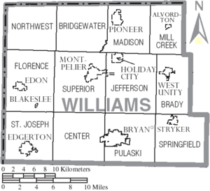
Townships
- Brady
- Bridgewater
- Center
- Florence
- Jefferson
- Madison
- Mill Creek
- Northwest
- Pulaski
- St. Joseph
- Springfield
- Superior
Census-designated places
These are areas that are like towns but are not officially incorporated as cities or villages.
- Alvordton
- Kunkle
- Lake Seneca
- Nettle Lake
- Pulaski
Unincorporated communities
These are smaller communities that are not part of any city or village.
- Berlin
- Bridgewater Center
- Columbia
- Cooney
- Hamer
- Lock Port
- Melbern
- Mina
- West Jefferson
- Williams Center
See also
 In Spanish: Condado de Williams (Ohio) para niños
 | Janet Taylor Pickett |
 | Synthia Saint James |
 | Howardena Pindell |
 | Faith Ringgold |


