
Fulton County, Ohio facts for kids
Quick facts for kids
Fulton County
|
|||
|---|---|---|---|

|
|||
|
|||

Location within the U.S. state of Ohio
|
|||
 Ohio's location within the U.S. |
|||
| Country | |||
| State | |||
| Founded | April 1, 1850 | ||
| Named for | Robert Fulton | ||
| Seat | Wauseon | ||
| Largest city | Wauseon | ||
| Area | |||
| • Total | 407 sq mi (1,050 km2) | ||
| • Land | 405 sq mi (1,050 km2) | ||
| • Water | 1.8 sq mi (5 km2) 0.4%% | ||
| Population
(2020)
|
|||
| • Total | 42,713 |
||
| • Density | 100/sq mi (40/km2) | ||
| Time zone | UTC−5 (Eastern) | ||
| • Summer (DST) | UTC−4 (EDT) | ||
| Congressional district | 9th | ||


Fulton County is a county found in the state of Ohio. It is located west of the city of Toledo. In 2020, about 42,713 people lived here. The main city and county seat is Wauseon. The county was created in 1850. It was formed from parts of Henry, Lucas, and Williams counties. Fulton County is named after Robert Fulton. He was famous for inventing the steamboat. This county is also part of the Toledo metropolitan area.
Contents
History of Fulton County
The first county seat in Fulton County was Ottokee. It was chosen because it was in the middle of the county. A wooden courthouse was built there in 1851.
However, a new railroad was built further south. The town of Wauseon started to grow in 1854. This happened when the railroad line reached that area. Wauseon became an official town in 1859. The railroad brought a lot of business and success to Wauseon. Because of this, the people of the county voted in 1871 to move the county seat to Wauseon. The Fulton County Courthouse was then built in Wauseon in 1872.
-
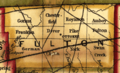
1851 Railroad map: Ottokee is the county seat of justice.
-
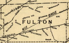
1890 Railroad map: Wauseon is now the county seat.


Geography of Fulton County

Fulton County covers a total area of about 407 square miles. Most of this area, about 405 square miles, is land. The rest, about 1.8 square miles, is water.
Neighboring Counties
Fulton County shares borders with several other counties:
- Lenawee County, Michigan (to the north)
- Lucas County (to the east)
- Henry County (to the south)
- Williams County (to the west)
- Hillsdale County, Michigan (to the northwest)
Nature and Parks
Fulton County has several protected natural areas where you can explore and enjoy nature:
- Goll Woods State Nature Preserve
- Harrison Lake State Park
- Maumee State Forest
- Tiffin River Wildlife Area
- Wabash Cannonball Trail
Population and People
| Historical population | |||
|---|---|---|---|
| Census | Pop. | %± | |
| 1850 | 7,781 | — | |
| 1860 | 14,043 | 80.5% | |
| 1870 | 17,789 | 26.7% | |
| 1880 | 21,053 | 18.3% | |
| 1890 | 22,023 | 4.6% | |
| 1900 | 22,801 | 3.5% | |
| 1910 | 23,914 | 4.9% | |
| 1920 | 23,445 | −2.0% | |
| 1930 | 23,477 | 0.1% | |
| 1940 | 23,626 | 0.6% | |
| 1950 | 25,580 | 8.3% | |
| 1960 | 29,301 | 14.5% | |
| 1970 | 33,071 | 12.9% | |
| 1980 | 37,751 | 14.2% | |
| 1990 | 38,498 | 2.0% | |
| 2000 | 42,084 | 9.3% | |
| 2010 | 42,698 | 1.5% | |
| 2020 | 42,713 | 0.0% | |
| U.S. Decennial Census 1790-1960 1900-1990 1990-2000 2020 |
|||
In 2010, there were 42,698 people living in Fulton County. The population density was about 105 people per square mile. Most people in the county were white (94.9%). About 7.8% of the population was of Hispanic or Latino background. Many people in the county have German (45.5%), Irish (11.9%), or English (10.7%) ancestry.
The average age of people in the county was about 39.9 years old.
Getting Around Fulton County
Airport
The Fulton County Airport is a public airport. It is located about 5 miles north of Wauseon, Ohio. The Fulton County Commissioners own and operate this airport.
Major Roads
Many important roads and highways pass through Fulton County, connecting its communities:
 Ohio Turnpike
 I-80
I-80 I-90
I-90
 US 20
US 20 US 20A
 US 127
 SR 2
SR 2 SR 64
SR 64 SR 66
SR 66 SR 108
 SR 109
 SR 120
Communities in Fulton County

Fulton County has several different types of communities:
Cities
- Wauseon (This is the county seat)
Villages
Census-Designated Places
These are areas that are like towns but are not officially incorporated as cities or villages:
Unincorporated Communities
These are smaller communities that are not officially part of a city or village:
See also
 In Spanish: Condado de Fulton (Ohio) para niños
