Lenawee County, Michigan facts for kids
Quick facts for kids
Lenawee County
|
|
|---|---|

|
|

Location within the U.S. state of Michigan
|
|
 Michigan's location within the U.S. |
|
| Country | |
| State | |
| Founded | 1822 (created) September 10, 1826 (organized) |
| Seat | Adrian |
| Largest city | Adrian |
| Area | |
| • Total | 761 sq mi (1,970 km2) |
| • Land | 750 sq mi (1,900 km2) |
| • Water | 12 sq mi (30 km2) 1.6%% |
| Population
(2020)
|
|
| • Total | 99,423 |
| • Estimate
(2023)
|
97,520 |
| • Density | 100/sq mi (50/km2) |
| Time zone | UTC−5 (Eastern) |
| • Summer (DST) | UTC−4 (EDT) |
| Congressional district | 5th |
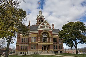
Lenawee County (pronounced LEN-ə-way) is a county in the U.S. state of Michigan. In 2020, about 99,423 people lived here. The main city and government center is Adrian. Lenawee County was first created in 1822 and officially organized in 1826. It was formed from parts of Monroe County.
Lenawee County is part of the Adrian, MI Micropolitan Statistical Area. This means it's a smaller city area connected to a larger one. It's also part of the Toledo media market, which means TV and radio from Toledo reach here. Many Native American tribes, like the Potawatomi, Ottawa, and Chippewa, once lived in this area.
Contents
History of Lenawee County
The land that became Lenawee County was first claimed by several Native American nations. These included the Ottawa, Ojibwe (also called Chippewa), Wyandot, and Potawatomi tribes. In 1807, they signed the Treaty of Detroit. This agreement gave their traditional lands in what is now southeast Michigan to the United States.
However, many tribal leaders felt forced to sign this treaty. They didn't agree with it. So, they started working together to resist the United States. This group was led by Chief Tecumseh, a Shawnee leader. They wanted to fight alongside Great Britain to make the U.S. leave their lands. This was during the War of 1812 between the U.S. and Great Britain. Battles like the Battle of Tippecanoe and the Battle of Lake Erie happened nearby.
In 1813, the U.S. won the Battle of the Thames. This battle defeated both the British and their Native American allies. Chief Tecumseh died in this battle, and his group broke apart. The city of Tecumseh in Lenawee County is named after him. After this defeat, the tribal leaders agreed to a peace treaty called the Treaty of Ghent. This treaty ended the war with the Native American peoples. It also confirmed that the U.S. controlled the land from the Treaty of Detroit. This land included what would become Lenawee County.
The U.S. government continued to move Native American tribes from their lands. In 1830, President Andrew Jackson signed the Indian Removal Act. This law allowed the government to move Indigenous peoples from east of the Mississippi River to lands in the west. These western lands later became known as Indian Territory (now Oklahoma). This act affected tribes in the Midwest, including those in Michigan.
Lenawee County was officially organized in 1826. It had been approved and described by the Michigan government in 1822. The land for the county was taken from Monroe County, Michigan.
What Does "Lenawee" Mean?
The name "Lenawee" was created by Henry Rowe Schoolcraft. He was a U.S. agent who worked with Native American tribes in the area. Schoolcraft later became famous for studying different cultures. He was married to Jane Johnston Schoolcraft, who had both Ojibwe and Scottish family. Through her, he learned about the Ojibwe language and culture.
While working in Michigan, Schoolcraft named several new counties. He often made up new words for these names. "Lenawee" is thought to come from a Native American word. Experts believe it might come from the Lenape language word leno or lenno, meaning "male." Or, it could come from the Shawnee word lenawai.
Geography of Lenawee County
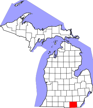
Lenawee County covers about 761 square miles. Most of this area, about 750 square miles, is land. The rest, about 12 square miles, is water. This means about 1.6% of the county is water. Lenawee County is located in the southeastern part of Michigan.
Neighboring Counties
Lenawee County shares borders with several other counties:
- Jackson County, to the northwest
- Washtenaw County, to the northeast
- Monroe County, to the east
- Lucas County, Ohio, to the southeast
- Fulton County, Ohio, to the southwest
- Hillsdale County, to the west
Main Roads and Highways
Several important roads run through Lenawee County:
 US 12
US 12 US 127
 US 223
 M-34
M-34 M-50
M-50 M-52
M-52- M-124
- M-156
In Lenawee County, roads that go north and south are often called "highways." Roads that go east and west are usually called "roads."
People of Lenawee County
| Historical population | |||
|---|---|---|---|
| Census | Pop. | %± | |
| 1830 | 1,491 | — | |
| 1840 | 17,889 | 1,099.8% | |
| 1850 | 26,372 | 47.4% | |
| 1860 | 38,112 | 44.5% | |
| 1870 | 45,595 | 19.6% | |
| 1880 | 48,343 | 6.0% | |
| 1890 | 48,448 | 0.2% | |
| 1900 | 48,406 | −0.1% | |
| 1910 | 47,907 | −1.0% | |
| 1920 | 47,767 | −0.3% | |
| 1930 | 49,849 | 4.4% | |
| 1940 | 53,110 | 6.5% | |
| 1950 | 64,629 | 21.7% | |
| 1960 | 77,789 | 20.4% | |
| 1970 | 81,609 | 4.9% | |
| 1980 | 89,948 | 10.2% | |
| 1990 | 91,476 | 1.7% | |
| 2000 | 98,890 | 8.1% | |
| 2010 | 99,892 | 1.0% | |
| 2020 | 99,423 | −0.5% | |
| 2023 (est.) | 97,520 | −2.4% | |
| US Decennial Census 1790-1960 1900-1990 1990-2000 2010-2018 |
|||
In 2000, there were 98,890 people living in Lenawee County. There were about 35,930 households, which are groups of people living together. The population density was about 132 people for every square mile.
Most people in the county, about 92.5%, identified as White. About 2.1% were Black or African American, and 0.4% were Native American. About 6.9% of the population identified as Hispanic or Latino. Many residents have German (30.4%), English (11.6%), American (10.2%), or Irish (9.9%) family backgrounds. Most people (94.7%) speak English at home, and 4.2% speak Spanish.
About 34.2% of households had children under 18 living with them. The average household had about 2.6 people. The average family had about 3.0 people.
The median age in the county was 36 years old. This means half the people were younger than 36, and half were older. About 25.9% of the population was under 18 years old.
Communities in Lenawee County
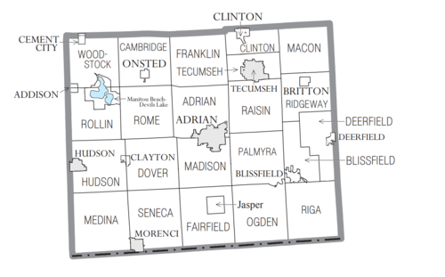
Lenawee County has several different types of communities:
Cities
Villages
- Addison
- Blissfield
- Britton
- Cement City (part of it is in another county)
- Clayton
- Clinton
- Deerfield
- Onsted
Charter Townships
These are special types of townships with more local control:
- Adrian Charter Township
- Madison Charter Township
- Raisin Charter Township
Civil Townships
These are other local government areas:
- Blissfield Township
- Cambridge Township
- Clinton Township
- Deerfield Township
- Dover Township
- Fairfield Township
- Franklin Township
- Hudson Township
- Macon Township
- Medina Township
- Ogden Township
- Palmyra Township
- Ridgeway Township
- Riga Township
- Rollin Township
- Rome Township
- Seneca Township
- Tecumseh Township
- Woodstock Township
Census-Designated Places
These are areas that are not officially cities or villages, but are recognized for census purposes:
- Jasper (This place was called Fairfield before 1874)
- Manitou Beach–Devils Lake
Other Unincorporated Communities
These are smaller places that are not officially part of a city or village:
- Birdsall
- Cadmus
- Canandaigua
- Dover
- East Ogden
- East Raisin
- Evans Lake
- Fairfield
- Geneva
- Gorman
- Ridgeville
- Ridgeway
- Riga
- Springville
- Tipton
- Weston
- Sand Creek
See also
 In Spanish: Condado de Lenawee para niños
 | James Van Der Zee |
 | Alma Thomas |
 | Ellis Wilson |
 | Margaret Taylor-Burroughs |


