Manitou Beach–Devils Lake, Michigan facts for kids
Quick facts for kids
Manitou Beach–Devils Lake, Michigan
|
|
|---|---|

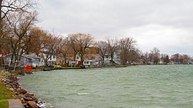
Round Lake Highway along Devils Lake
|
|

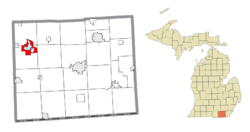
Location within Lenawee County
|
|
| Country | United States |
| State | Michigan |
| County | Lenawee |
| Townships | Rollin and Woodstock |
| Settled | 1833 |
| Area | |
| • Total | 8.94 sq mi (23.15 km2) |
| • Land | 6.08 sq mi (15.75 km2) |
| • Water | 2.86 sq mi (7.41 km2) |
| Elevation | 1,043 ft (318 m) |
| Population
(2020)
|
|
| • Total | 2,032 |
| • Density | 334.21/sq mi (129.04/km2) |
| Time zone | UTC-5 (Eastern (EST)) |
| • Summer (DST) | UTC-4 (EDT) |
| ZIP code(s) |
49253 (Manitou Beach)
49220 (Addison) |
| Area code(s) | 517 |
| FIPS code | 26-50830 |
| GNIS feature ID | 2393118 |
Manitou Beach–Devils Lake is a special area in Lenawee County, Michigan. It is called a census-designated place (CDP). This means it's a place that the government counts for population, but it's not officially a city or town. In 2020, about 2,032 people lived here.
This area includes the communities of Devils Lake, Geneva, and Manitou Beach. It also features two large lakes: Devils Lake and Round Lake. The CDP is located across parts of Rollin Township and Woodstock Township.
Contents
Exploring the Communities of Manitou Beach–Devils Lake
This CDP is made up of a few smaller communities, each with its own location and history.
Devils Lake Community
The community of Devils Lake is found at the northern end of the lake called Devils Lake. It is located along U.S. Route 223. This area is known for its connection to the lake.
Geneva Community
Geneva is a community located at the southern end of the smaller Round Lake. This lake is to the southeast of Devils Lake.
Manitou Beach Community
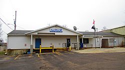
Manitou Beach is situated at the southwest end of Devils Lake. It is about 2.5 miles (4.0 km) southwest of the Devils Lake community. It is also about 2 miles (3.2 km) east-southeast of Addison. Manitou Beach has its own post office. This post office uses the 49523 ZIP Code. It serves most of the CDP and nearby areas.
A Look at the History of Manitou Beach–Devils Lake
The area around Devils Lake has a rich history. It was first home to the Potawatami people.
Early History and Native American Influence

Devils Lake was once a village for the Potawatami people. This was until around 1830. Many Potawatami people were forced to move west of the Mississippi River. This happened after the Indian Removal Act was passed by President Andrew Jackson.
The name 'Manitou Beach' comes from the Potawatami name for Devils Lake, which was "Michemanetue". This means "Lake of God." The name 'Devils Lake' itself has a story. A Potawatami leader named Meteau (or Mitteau) is said to have named it. He did so after his daughter drowned in the lake and her body was never found. He believed evil spirits had taken her.
Growth as a Resort Area
European-American settlers first arrived in the Manitou Beach area in the early 1830s. By the early 1900s, it became a very popular resort. It grew much faster than the Devils Lake community. Tourists would arrive by steam launches. They enjoyed hotels and fun attractions. These included bath houses, a dance pavilion, and places to rent boats. There was also a water slide, picnic areas, and restaurants.
The Manitou Beach post office opened on March 20, 1889. It closed for a short time but reopened in 1893. Manitou Beach was also a stop on the Cincinnati, Jackson and Mackinaw Railroad. The Devils Lake post office opened in 1885 and closed in 1936. The Detroit, Toledo and Milwaukee Railroad also had a stop there.
Recent Events and Rebuilding
In 1965, the Manitou Beach area was hit by two strong F4 tornadoes. This happened during the 1965 Palm Sunday tornado outbreak. Much of what was destroyed was rebuilt. This included the dance hall and two churches. Today, there are few reminders of the tornado.
More recently, the Devils Lake Drive-In-Church closed after 58 seasons. The Manitou Beach Inn, a well-known local business, was destroyed by fire in 2010. When the inn was rebuilt, it helped bring new life to the historic business area on Walnut Street.
Understanding the Geography of Manitou Beach–Devils Lake
The CDP covers an area of about 8.94 square miles (23.15 km²). A significant part of this area is water. About 2.86 square miles (7.41 km²) is water, which is about 32% of the total area.
Main Roads in the Area
- U.S. Route 223 forms the northern edge of the Manitou Beach–Devils Lake area.
Population and People of Manitou Beach–Devils Lake
The population of Manitou Beach–Devils Lake has stayed fairly steady over the years.
Population Changes Over Time
| Historical population | |||
|---|---|---|---|
| Census | Pop. | %± | |
| 1990 | 2,061 | — | |
| 2000 | 2,080 | 0.9% | |
| 2010 | 2,019 | −2.9% | |
| 2020 | 2,032 | 0.6% | |
| U.S. Decennial Census | |||
In 2000, there were 2,080 people living in the CDP. By 2020, the population was 2,032.
Who Lives Here?
In 2000, about 22% of the people were under 18 years old. About 14% were 65 years or older. The average age was 42 years. Most of the people living here were White. A small percentage were from other racial backgrounds or identified as Hispanic or Latino.
See also
 In Spanish: Manitou Beach-Devils Lake para niños
 | Bayard Rustin |
 | Jeannette Carter |
 | Jeremiah A. Brown |


