
Monroe County, Michigan facts for kids
Quick facts for kids
Monroe County
|
||
|---|---|---|
.jpg)
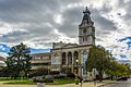
Monroe County Courthouse
|
||
|
||

Location within the U.S. state of Michigan
|
||
 Michigan's location within the U.S. |
||
| Country | ||
| State | ||
| Founded | July 14, 1817 | |
| Named for | James Monroe | |
| Seat | Monroe | |
| Largest city | Monroe | |
| Area | ||
| • Total | 680 sq mi (1,800 km2) | |
| • Land | 549 sq mi (1,420 km2) | |
| • Water | 131 sq mi (340 km2) 19% | |
| Population
(2020)
|
||
| • Total | 154,809 | |
| • Estimate
(2023)
|
155,045 |
|
| • Density | 227.7/sq mi (87.9/km2) | |
| Time zone | UTC−5 (Eastern) | |
| • Summer (DST) | UTC−4 (EDT) | |
| Congressional districts | 5th, 6th | |


Monroe County is a county in the U.S. state of Michigan. It's located in the southeastern part of the state. In 2020, about 154,809 people lived here. The biggest city and the main government center, called the county seat, is Monroe. The county was created in 1817 and was named after James Monroe, who was the President at that time.
Contents
History of Monroe County
Before Monroe County was officially formed, a main settlement called Frenchtown started around 1784. It was built along the River Raisin. Early French settlers were given this land by the Potawatomi Native Americans.
During the War of 1812, a big battle happened here called the Battle of Frenchtown. It was a very tough loss for the American forces. In fact, it's still the deadliest battle ever fought on Michigan soil. Today, you can visit the River Raisin National Battlefield Park where the battle took place.
Monroe County was officially created in 1817 from the southern part of Wayne County. At first, the Michigan Territory only had Wayne County. As more people moved in, the southern part was separated to form Monroe County. The settlement of Frenchtown was then renamed "Monroe."
The town of Monroe became the county seat in 1817. Both the county and the town were named after President James Monroe. This was done because he was planning to visit the city. In 1820, only 336 people lived in Monroe County. The county was much larger back then, but its western half became Lenawee County in 1826.
One of Monroe County's most famous residents was George Armstrong Custer (1839–1876). He moved to Monroe as a child and went to school there. Later, he became a famous general during the Civil War. In 1864, he returned to Monroe to marry Elizabeth Bacon. Many of Custer's family members are buried in Monroe's Woodland Cemetery. In 1910, a statue of Custer was put up in downtown Monroe.
Border Disputes and the Toledo War

When the city of Toledo was created in 1833, it was actually part of Monroe County, Michigan. This happened because of a disagreement over the border between the Michigan Territory and the state of Ohio. Ohio claimed the land around the Maumee River, which was important for trade.
From 1833 to 1836, Toledo belonged to Monroe County. This led to a big argument called the Toledo War. It was a border dispute between Michigan and Ohio. In 1836, President Andrew Jackson helped settle the problem. Ohio got the Toledo area. In return, Michigan received the Upper Peninsula when it became a state in 1837.
The new border created a small problem for Monroe County. A tiny piece of land, called the "Lost Peninsula", was cut off from the rest of Michigan. People living there have to drive through Ohio to get to other parts of Michigan. This area is managed by Erie Township.
Another border issue involved Turtle Island in Lake Erie. Michigan and Ohio both claimed it. In 1973, they agreed to split the island in half. Now, one part belongs to Monroe County, Michigan, and the other to Lucas County, Ohio.
Monroe County's Economy Through Time

For a long time, Monroe County was mostly about farming. It was also known for its many paper mills. The first one started in 1834.
In 1916, August Meyer started a company that made bicycle pumps. Later, in 1919, it began making car shocks and became the Monroe Auto Equipment Company. Today, it's part of a big company called Tenneco. They still make Monroe Shocks and Struts in Monroe Charter Township.
In 1927, cousins Edward Knabusch and Edwin Shoemaker started a small furniture company. This grew into the famous La-Z-Boy company, known for its comfy recliners. Their main office is in Monroe.
In 1957, the Enrico Fermi Nuclear Generating Station, a power plant, opened near Lake Erie. Another large power plant, the Monroe Power Plant, opened in 1974. It has very tall smokestacks, which are some of the tallest structures in Michigan.
Many other businesses have come to Monroe County. In 2001, Cabela's, a large outdoor store, opened in Dundee. This store attracts many visitors and has helped Dundee's economy. The Global Engine Manufacturing Alliance, which makes car engines, also started in Dundee in 2002.
Geography of Monroe County
Monroe County covers about 680 square miles. About 549 square miles are land, and 131 square miles (19%) are water. Monroe is the only county in Michigan that touches Lake Erie. The River Raisin and Sandy Creek flow through the county.
Sterling State Park is the only state park in Monroe County. It's also the only one of Michigan's 98 state parks located on Lake Erie. The Detroit River International Wildlife Refuge also extends into Monroe County. The lowest point in Michigan is on the shores of Lake Erie in Monroe County.
Neighboring Counties
Monroe County shares borders with these other areas:
- Wayne County (to the northeast)
- Washtenaw County (to the northwest)
- Essex County, Ontario, Canada (to the east, across Lake Erie)
- Lenawee County (to the west)
- Lucas County, Ohio (to the south)
Monroe County's Climate
Monroe County has a humid continental climate. This means it has warm summers and cold winters. The city of Monroe gets about 28.5 inches of snow each year, which is less than many other large cities in Michigan.
July is usually the warmest month, with high temperatures around 84 °F. January is the coldest, with low temperatures around 16 °F. It's rare for temperatures to drop below 0 °F in winter or go above 100 °F in summer. The coldest temperature ever recorded was -21 °F in 1918. The hottest was 106 °F in 1934.
Strong weather events like tornadoes are not very common. Since 1950, Monroe County has had about 30 tornadoes. Sometimes, waterspouts can be seen over Lake Erie. Most tornadoes have been part of larger outbreaks, but they haven't usually hit the most populated areas directly.
For example, in 1965, three strong tornadoes caused 13 deaths. In 1974, two tornadoes caused five deaths. The most tornadoes in one day happened in 1979, with four weak tornadoes, but no one was hurt. The most recent tornado to cause damage was in Dundee Township in 2010.
Monroe County is too far north for hurricanes to hit directly. However, some strong hurricanes have caused extra rain and strong winds in the area after they lost most of their power.
Population Information
| Historical population | |||
|---|---|---|---|
| Census | Pop. | %± | |
| 1830 | 3,187 | — | |
| 1840 | 9,922 | 211.3% | |
| 1850 | 14,698 | 48.1% | |
| 1860 | 21,593 | 46.9% | |
| 1870 | 27,483 | 27.3% | |
| 1880 | 33,624 | 22.3% | |
| 1890 | 32,337 | −3.8% | |
| 1900 | 32,754 | 1.3% | |
| 1910 | 32,917 | 0.5% | |
| 1920 | 37,115 | 12.8% | |
| 1930 | 52,485 | 41.4% | |
| 1940 | 58,620 | 11.7% | |
| 1950 | 75,666 | 29.1% | |
| 1960 | 101,120 | 33.6% | |
| 1970 | 118,479 | 17.2% | |
| 1980 | 134,659 | 13.7% | |
| 1990 | 133,600 | −0.8% | |
| 2000 | 145,945 | 9.2% | |
| 2010 | 152,021 | 4.2% | |
| 2020 | 154,809 | 1.8% | |
| 2023 (est.) | 155,045 | 2.0% | |
| U.S. Decennial Census 1790-1960 1900-1990 1990-2000 2010-2019 |
|||
In 2000, there were 145,945 people living in Monroe County. Most people (95.42%) were White. About 1.90% were Black or African American. Other groups included Native American (0.28%) and Asian (0.47%). About 2.13% of the population were Hispanic or Latino.
Many people in Monroe County have German roots (28.5%). Other common backgrounds include American (8.9%), Polish (8.3%), French (8.2%), Irish (8.0%), English (7.5%), and Italian (5.7%). Most people (96.4%) speak English at home.
In 2000, about 36% of households had children under 18. The average family size was 3.14 people. The median age in the county was 36 years old. This means half the people were younger than 36 and half were older.
Education in Monroe County
Monroe County has nine public school districts. Around 23,000 students attend public schools here. Students can often choose to attend any district in the county, even if they don't live there. However, the school might not provide transportation.
There are also two charter schools and 15 parochial schools (private schools, often religious). The Monroe County Intermediate School District helps all schools in the county with educational services.
Monroe County Community College is the only college in the county. It opened in 1967. A Catholic college called Marygrove College was founded in Monroe in 1905, but it later moved to Detroit.
Public School Districts
Monroe County is served by 14 public school districts. Nine of these are based within the county. The largest is Monroe Public Schools, which has about 6,450 students. Monroe High School is one of the biggest high schools in Michigan.
Here are some of the school districts in Monroe County:
- Airport Community School District
- Bedford Public Schools
- Dundee Community Schools
- Ida Public School District
- Jefferson Schools
- Mason Consolidated Schools
- Monroe Public Schools
- Summerfield School District
- Whiteford Agricultural School District
- Secondary school
- Primary school
- Alternative school
- Specialized learning centers
| District | School | Location | |
|---|---|---|---|
| Airport Community Schools |
Airport Senior High School | Ash Township | 42°02′24″N 83°22′35″W / 42.04000°N 83.37639°W |
| Edith M. Wagar Middle School | Ash Township | 42°02′18″N 83°22′44″W / 42.03833°N 83.37889°W | |
| Fred W. Ritter Elementary School | South Rockwood | 42°03′43″N 83°16′21″W / 42.06194°N 83.27250°W | |
| Joseph C. Sterling Elementary School | Ash Township | 42°02′31″N 83°22′39″W / 42.04194°N 83.37750°W | |
| Loren Eyler Elementary School | Ash Township | 42°03′56″N 83°21′10″W / 42.06556°N 83.35278°W | |
| Niedermeier Elementary School | Berlin Township | 41°59′57″N 83°18′36″W / 41.99917°N 83.31000°W | |
| Bedford Public Schools | Bedford Junior High School | Temperance | 41°46′07″N 83°35′19″W / 41.76861°N 83.58861°W |
| Bedford Senior High School | Temperance | 41°45′58″N 83°35′20″W / 41.76611°N 83.58889°W | |
| Douglas Road Elementary School | Lambertville | 41°44′26″N 83°36′26″W / 41.74056°N 83.60722°W | |
| Jackman Road Elementary School | Temperance | 41°45′41″N 83°35′10″W / 41.76139°N 83.58611°W | |
| Monroe Road Elementary School | Lambertville | 41°45′26″N 83°38′17″W / 41.75722°N 83.63806°W | |
| Open Door Alternative High School | Temperance | 41°44′58″N 83°35′01″W / 41.74944°N 83.58361°W | |
| Smith Road Elementary School | Temperance | 41°44′06″N 83°34′14″W / 41.73500°N 83.57056°W | |
| Temperance Road Elementary School | Temperance | 41°46′41″N 83°34′59″W / 41.77806°N 83.58306°W | |
| Dundee Community Schools | Dundee Alternative High School | Dundee | 41°57′13″N 83°39′33″W / 41.95361°N 83.65917°W |
| Dundee Elementary School | Dundee | 41°57′37″N 83°39′28″W / 41.96028°N 83.65778°W | |
| Dundee High School | Dundee | 41°57′45″N 83°39′44″W / 41.96250°N 83.66222°W | |
| Dundee Middle School | Dundee | 41°57′40″N 83°39′32″W / 41.96111°N 83.65889°W | |
| Ida Public Schools | Ida Elementary School | Ida Township | 41°54′27″N 83°34′04″W / 41.90750°N 83.56778°W |
| Ida High School | Ida Township | 41°54′23″N 83°34′11″W / 41.90639°N 83.56972°W | |
| Ida Middle School | Ida Township | 41°54′22″N 83°34′17″W / 41.90611°N 83.57139°W | |
| Jefferson Schools | Harold F. Sodt Elementary School | Frenchtown Township | 41°56′45″N 83°19′14″W / 41.94583°N 83.32056°W |
| Jefferson 5/6 Elementary School | Frenchtown Township | 41°57′12″N 83°18′46″W / 41.95333°N 83.31278°W | |
| Jefferson Early Childhood Center | Frenchtown Township | 41°56′17″N 83°20′56″W / 41.93806°N 83.34889°W | |
| Jefferson High School | Frenchtown Township | 41°57′24″N 83°18′42″W / 41.95667°N 83.31167°W | |
| Jefferson Middle School | Frenchtown Township | 41°57′15″N 83°18′45″W / 41.95417°N 83.31250°W | |
| North Elementary School | Berlin Township | 41°59′55″N 83°16′43″W / 41.99861°N 83.27861°W | |
| Mason Consolidated Schools | Mason Central Elementary School | Erie Township | 41°48′38″N 83°29′27″W / 41.81056°N 83.49083°W |
| Mason Middle School | Erie Township | 41°48′38″N 83°29′36″W / 41.81056°N 83.49333°W | |
| Mason Senior High School | Erie Township | 41°48′48″N 83°29′29″W / 41.81333°N 83.49139°W | |
| Monroe Public Schools | Custer #1 Elementary School | South Monroe | 41°53′01″N 83°25′57″W / 41.88361°N 83.43250°W |
| Custer #2 Elementary School | South Monroe | 41°52′58″N 83°26′04″W / 41.88278°N 83.43444°W | |
| Cantrick Elementary School | Monroe | 41°55′37″N 83°22′56″W / 41.92694°N 83.38222°W | |
| Hollywood Elementary School | Monroe | 41°55′45″N 83°22′58″W / 41.92917°N 83.38278°W | |
| Knabusch Mathematics & Science Center | Monroe Township | 41°52′30″N 83°23′27″W / 41.87500°N 83.39083°W | |
| Manor Elementary School | Monroe | 41°55′56″N 83°25′05″W / 41.93222°N 83.41806°W | |
| Monroe High School | West Monroe | 41°55′07″N 83°26′17″W / 41.91861°N 83.43806°W | |
| Monroe Middle School | Monroe | 41°54′39″N 83°23′58″W / 41.91083°N 83.39944°W | |
| Orchard Center High School | Monroe | 41°54′05″N 83°22′42″W / 41.90139°N 83.37833°W | |
| Raisinville Elementary School | Raisinville Township | 41°58′14″N 83°26′47″W / 41.97056°N 83.44639°W | |
| Riverside Early Childhood Center | Monroe | 41°55′21″N 83°24′31″W / 41.92250°N 83.40861°W | |
| Waterloo Elementary School | West Monroe | 41°55′12″N 83°25′33″W / 41.92000°N 83.42583°W | |
| Summerfield Schools | Summerfield Elementary School | Petersburg | 41°53′59″N 83°42′32″W / 41.89972°N 83.70889°W |
| Summerfield High School | Petersburg | 41°54′18″N 83°42′07″W / 41.90500°N 83.70194°W | |
| Summerfield Middle School | Petersburg | 41°54′20″N 83°42′09″W / 41.90556°N 83.70250°W | |
| Whiteford Agricultural Schools | Whiteford Elementary School | Whiteford Township | 41°45′58″N 83°42′15″W / 41.76611°N 83.70417°W |
| Whiteford High School | Whiteford Township | 41°46′05″N 83°42′08″W / 41.76806°N 83.70222°W | |
| Whiteford Middle School | Whiteford Township | 41°46′04″N 83°42′14″W / 41.76778°N 83.70389°W | |
- Public charter school
- Parochial school
- Independent school
| School | Location | Grades | Enrollment | |
|---|---|---|---|---|
| Holy Ghost Lutheran School | Raisinville Township | 41°59′32″N 83°25′44″W / 41.99222°N 83.42889°W | Pre–8 | 100 |
| Meadow Montessori School | Raisinville Township | 41°54′50″N 83°28′39″W / 41.91389°N 83.47750°W | Infant–12 | 180 |
| Monroe Catholic Elementary Schools: St. Michael Early Elementary School, St. John Elementary School, St. Mary Middle School | Monroe | N/A | Infant–8 | 531 |
| New Bedford Academy | Lambertville | 41°43′48″N 83°37′37″W / 41.73000°N 83.62694°W | K–8 | 150 |
| St. Charles School | Berlin Township | 41°59′43″N 83°17′18″W / 41.99528°N 83.28833°W | Pre–8 | 177 |
| St. Joseph School | Erie Township | 41°54′42″N 83°24′05″W / 41.91167°N 83.40139°W | Pre–8 | 110 |
| St. Mary Catholic Central High School | Monroe | 41°55′10″N 83°23′53″W / 41.91944°N 83.39806°W | 9–12 | 425 |
| St. Patrick Catholic School | Ash Township | 42°01′32″N 83°25′06″W / 42.02556°N 83.41833°W | K–8 | 134 |
| State Line Christian School | Temperance | 41°44′03″N 83°33′59″W / 41.73417°N 83.56639°W | Pre–12 | 275 |
| Trinity Lutheran School | Monroe | 41°54′42″N 83°23′46″W / 41.91167°N 83.39611°W | Pre–8 | 205 |
| Triumph Academy | Frenchtown Township | 41°57′13″N 83°21′43″W / 41.95361°N 83.36194°W | K–8 | 600 |
| Zion Lutheran School | Frenchtown Township | 41°56′12″N 83°23′00″W / 41.93667°N 83.38333°W | Pre–8 | 94 |
| School | Location | Classification | |
|---|---|---|---|
| Monroe County Community College | Monroe Township | 41°55′01″N 83°28′08″W / 41.91694°N 83.46889°W | Community college |
| Monroe County Intermediate School District | Monroe Township | 41°55′26″N 83°28′01″W / 41.92389°N 83.46694°W | Intermediate school district |
| Monroe County Middle College | Monroe Township | 41°55′01″N 83°28′08″W / 41.91694°N 83.46889°W | Alternative high school |
| Monroe County Youth Center | Monroe Township | 41°55′55″N 83°27′32″W / 41.93194°N 83.45889°W | Youth detention center |
| Moreau Center | Frenchtown Township | 41°57′45″N 83°22′01″W / 41.96250°N 83.36694°W | Youth detention center |
Fun Places and Landmarks
Monroe County has many interesting places to visit:
- Custer Airport
- Detroit River International Wildlife Refuge
- George Armstrong Custer Equestrian Monument (a statue of General Custer)
- La-Z-Boy world headquarters (where the famous recliners are made)
- Monroe County Fair (a fun annual event)
- Monroe County Historical Museum (learn about the county's past)
- Monroe Power Plant (a very large power plant)
- Navarre-Anderson Trading Post (a historic trading post)
- Old Mill Museum
- River Raisin National Battlefield Park (where the Battle of Frenchtown happened)
- Sterling State Park (a state park on Lake Erie)
- The Mall of Monroe (a shopping mall)
- Woodland Cemetery (a historic cemetery)
Getting Around Monroe County
Some parts of Monroe County have a public bus system called Lake Erie Transit. It started in 1975 and has many buses that serve thousands of riders every year. The buses run on set routes around the city of Monroe. They can also take people to shopping malls in Toledo, Ohio.
Major Roads and Highways
Several important roads and highways pass through Monroe County:
 I-75: This interstate highway goes through the eastern part of the county. It connects to Toledo in the south and Detroit in the north. You can drive on I-75 all the way to Florida!
 I-275: This highway starts just north of Monroe. It's a bypass around Detroit and connects to the Metro Airport.
 US 23: This highway runs along the western side of the county, passing through Dundee. It's a freeway with no stoplights.
 US 24: This road goes through Monroe and connects to Toledo and parts of Detroit. It's known locally as North Telegraph and South Telegraph.
 M-50: This road starts in Monroe and goes through Dundee and further into Michigan.
- M-125: This road goes right through downtown Monroe.
Airports
Monroe County has two airports for smaller planes:
 Custer Airport: Built in 1946, it's west of downtown Monroe. It's used by small private planes and has a flight school.
- Toledo Suburban Airport: Located in the southwest part of the county near Lambertville. It's also for private planes and offers fueling and flight lessons.
Communities in Monroe County
.png)
Monroe County has different types of communities:
Cities
- Flat Rock (partially)
- Luna Pier
- Milan (partially)
- Monroe (the county seat)
- Petersburg
Villages
Charter Townships
- Berlin Charter Township
- Frenchtown Charter Township
- Monroe Charter Township
Civil Townships
- Ash Township
- Bedford Township
- Dundee Township
- Erie Township
- Exeter Township
- Ida Township
- La Salle Township
- London Township
- Milan Township
- Raisinville Township
- Summerfield Township
- Whiteford Township
Census-Designated Places (CDPs)
These are areas that are like towns but are not officially incorporated:
Other Unincorporated Communities
These are smaller communities that are not officially part of a city or village:
Famous People from Monroe County
Many notable people have lived in or come from Monroe County:
- Christie Brinkley (born 1954), a famous model
- Elizabeth Bacon Custer (1842–1933), wife of General Custer, was born here
- George Armstrong Custer (1839–1876), a famous Civil War general who lived much of his early life in Monroe
- J. Sterling Morton (1832–1902), a well-known conservationist
- Kaye Lani Rae Rafko (born 1963), who won Miss America in 1988
- Mary Harris Jones (1837–1930), a famous union organizer known as "Mother Jones"
- Robert McCelland (1807–1880), an important Michigan politician
- Vic Braden (1929–2014), a former tennis champion and coach
Images for kids
-
Monroe County Courthouse
See also
 In Spanish: Condado de Monroe (Míchigan) para niños
