
River Raisin facts for kids
Quick facts for kids River Raisin |
|
|---|---|

|
|

Location of the River Raisin in Michigan
|
|
| Other name(s) | Rivière Aux Raisins |
| Country | United States |
| State | Michigan |
| Cities | Blissfield, Brooklyn, Clinton, Deerfield, Dundee, Manchester, Monroe, Petersburg, Tecumseh |
| Physical characteristics | |
| Main source | Rollin Township, Michigan 1,043 ft (318 m) 42°01′29″N 84°16′05″W / 42.02472°N 84.26806°W |
| River mouth | Lake Erie Monroe, Michigan 571 ft (174 m) 41°53′31″N 83°20′12″W / 41.89194°N 83.33667°W |
| Length | 139 mi (224 km) |
| Basin features | |
| Basin size | 1,072 sq mi (2,780 km2) |
The River Raisin is a river in southeastern Michigan, United States. It flows through land shaped by ancient glaciers and empties into Lake Erie. Today, the area around the river is important for both farming and factories.
The River Raisin is about 139 miles (224 km) long. It drains an area of 1,072 square miles (2,780 km2) across several Michigan counties. Its mouth, where it meets Lake Erie, is in Monroe County. French settlers named it La Rivière aux Raisins because of the wild grapes growing along its banks. In French, raisin means grape.
Contents
A Journey Through Time
The River Raisin was important to the local Potawatomi and Wyandot tribes. They used a special path, called a portage, to carry their canoes between the upper river and other rivers. This allowed them to travel west toward Lake Michigan.
The river is still good for canoeing along its whole length. However, there are 22 dams and many logjams that can make recreational use a bit tricky.
The first European settlers were French-Canadians in the 1780s. They created unique "ribbon" farms. These farms had narrow fronts along the river, giving many farmers river access. The farms then stretched far back from the river. This area is now part of Monroe, Michigan, and it's still the most populated place along the river. The Irish Hills resort area is near the river's source. This area has 429 lakes and ponds, with Lake Columbia being the largest at 800-acre (3.2 km2).
The War of 1812 and "Remember the Raisin"
During the winter of 1813, a major battle of the War of 1812 happened near the river. This was the Battle of Frenchtown. British and Native American troops fought against American soldiers from Kentucky.
The American general, James Winchester, surrendered to the British. The British promised safety for the prisoners. However, the next day, many wounded American prisoners were tragically killed by the Native American allies of the British. This event became known as the Massacre of the River Raisin.

The cry "Remember the Raisin" became a powerful slogan for Americans, especially for the Kentuckians, during the war. Later, American troops returned and drove the British out of Michigan. The battlefield is now the River Raisin National Battlefield Park. It is the only National Battlefield Park dedicated to a War of 1812 battle.
River Health and Changes
Over time, factories and intense farming have caused pollution in the river. This includes industrial waste and runoff from farms. While people have worked hard to clean it up, some harmful chemicals called PCBs are still present.
Environmental experts advise people not to eat certain types of fish caught below the Monroe Dam. This is because of the pollution.
The river has many small dams. These dams were built in the mid-1800s to power paper mills during a time when lumber was very important. They were also part of Henry Ford's plan for rural industries. The biggest dam is in Dundee, Michigan. The Port of Monroe was built near the river's mouth in the 1930s. This was a big project during the Great Depression to help the economy.
Flooding Along the River
Flooding along the River Raisin can happen for three main reasons:
- Heavy rains.
- Ice dams forming when ice breaks up in spring.
- Strong winds from Lake Erie pushing water upstream.
The worst flood ever recorded was on March 16, 1982. On the other hand, during a severe drought on July 13, 1988, a measuring station found no water flowing at all.
Most of the river's water is now sent through the Detroit Edison power plant. This helps to limit more pollution near the river's mouth. The power plant uses a lot of water. Sometimes, it even pulls water from Lake Erie upstream into the plant. This high water use can harm fish by trapping them in intake screens. It also makes it hard for fish to travel between the river and the Great Lakes.
In 2013, Tim Walberg, a U.S. Representative from Michigan, helped introduce a resolution to honor the 200th anniversary of the battles at the River Raisin.
Streams Flowing into the River Raisin
The River Raisin is formed by the Upper River Raisin and the South Branch River Raisin. Other streams that flow into it include:
- Goose Creek
- Black Creek
- Evans Creek
- Iron Creek
- Little River Raisin
- Macon Creek
- Saline River
Islands in the River
The Eagle Island Marsh is a special wetland area. It is part of the Detroit River International Wildlife Refuge.
Nature Along the River

The River Raisin is home to many "warm-water" fish. These include:
- Bluegill
- White sucker
- Channel catfish
- Walleye
- Carp
- White bass
- Black buffalo
- Freshwater drum
- Smallmouth bass
Unfortunately, not many fish can travel between the river and the Great Lakes. This is because of the seven dams in Monroe and the power plant's water intakes.
Birds and Other Animals
Many bird species use the River Raisin area as a stop on their migratory flyway along eastern Lake Erie. You might see:
- Bald eagles
- Sandhill cranes
- Ducks
- Seagulls
Some non-native animals have also moved into the river. These are called invasive species and include zebra mussels and rusty crayfish.
Plants of the River Raisin
The threatened American lotus plant grows in Eagle Island Marsh. However, it has to compete with several invasive plant species. These include:
- Flowering rush
- Eurasian milfoil
- Curlyleaf pondweed
- Phragmites
- Purple loosestrife
Communities Along the River

Many towns are located along the River Raisin, including:
- Tecumseh, Michigan
- Adrian, Michigan
- Blissfield, Michigan
- Clinton, Michigan
- Dundee, Michigan
- Petersburg, Michigan
- Manchester, Michigan
- Monroe, Michigan
- Deerfield, Michigan
Images for kids
-
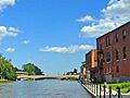
The River Raisin passing through Monroe, Michigan
-
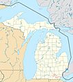
Location of the River Raisin in Michigan
-
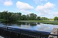
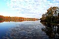
River Raisin through Sharon Township
-
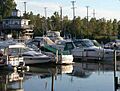
Boats docked near the mouth of River Raisin
-
Red Millpond, Tecumseh
