
Sisters Island (Michigan) facts for kids

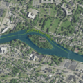
USGS aerial imagery of Sisters Island
|
|

Sisters Island
Location in Michigan

Sisters Island
Location in the United States
|
|
| Geography | |
|---|---|
| Location | Michigan |
| Coordinates | 41°55′10″N 83°24′15″W / 41.91944°N 83.40417°W |
| Adjacent bodies of water | River Raisin |
| Highest elevation | 587 ft (178.9 m) |
| Administration | |
|
United States
|
|
| State | |
| County | Monroe |
Sisters Island is a small piece of land completely surrounded by water. It is located in the River Raisin, a river that flows through Monroe County, Michigan, in the United States.
This island is a natural feature of the river. It helps make the landscape of the area unique.
Contents
Where is Sisters Island Located?
Sisters Island is found within the borders of Monroe County, which is in the state of Michigan. It sits right in the middle of the River Raisin.
Understanding Its Exact Spot
To pinpoint Sisters Island on a map, we use something called geographic coordinates. These are like an address for any place on Earth.
- The coordinates for Sisters Island are 41°55′10″N 83°24′15″W / 41.91944°N 83.40417°W.
- The "N" stands for North latitude, and "W" stands for West longitude. This tells us its position on the globe.
How High is Sisters Island?
The height of Sisters Island above sea level is called its elevation. This measurement helps us understand how high a piece of land is.
- In 1980, the United States Geological Survey (USGS) measured the island's elevation.
- They found it to be 587 ft (179 m) above sea level. This means it's about 179 meters high.
Images for kids
-
USGS aerial imagery of Sisters Island

All content from Kiddle encyclopedia articles (including the article images and facts) can be freely used under Attribution-ShareAlike license, unless stated otherwise. Cite this article:
Sisters Island (Michigan) Facts for Kids. Kiddle Encyclopedia.