Sterling Island facts for kids

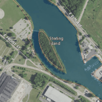
USGS aerial imagery of Sterling Island
|
|
| Geography | |
|---|---|
| Location | Southeast Michigan |
| Coordinates | 41°54′30″N 83°22′39″W / 41.90833°N 83.37750°W |
| Adjacent bodies of water | River Raisin |
| Highest elevation | 571 ft (174 m) |
| Administration | |
|
United States
|
|
| State | |
| County | Monroe |
Sterling Island is a special piece of land in Monroe County, Michigan. It's not a natural island; it was actually built by people! This man-made island sits in the River Raisin, which flows into the big Lake Erie.
Discover Sterling Island
Sterling Island is a unique spot located in the southeastern part of Michigan. It's found within Monroe County. This island is special because it was created by humans, not by nature.
Where is Sterling Island Located?
This interesting island is right in the middle of the River Raisin. The River Raisin is a waterway that eventually flows into Lake Erie, one of the Great Lakes. So, Sterling Island is very close to a major body of water.
What is the Island's Elevation?
In 1980, the United States Geological Survey (USGS) measured the height of Sterling Island. They found its elevation to be 571 feet (about 174 meters) above sea level. This measurement helps us understand how high the island sits.
 | Dorothy Vaughan |
 | Charles Henry Turner |
 | Hildrus Poindexter |
 | Henry Cecil McBay |


