
Dundee, Michigan facts for kids
Quick facts for kids
Dundee, Michigan
|
|
|---|---|
|
Village
|
|

Dundee Historic District along M-50
|
|
,_MI_location_2020.png)
Location within Monroe County and the state of Michigan
|
|

Dundee, Michigan
Location in Michigan

Dundee, Michigan
Location in the United States
|
|
| Country | United States |
| State | Michigan |
| County | Monroe |
| Township | Dundee |
| Settled | 1823 |
| Incorporated | 1855 |
| Government | |
| • Type | Village council |
| Area | |
| • Total | 5.28 sq mi (13.68 km2) |
| • Land | 5.24 sq mi (13.57 km2) |
| • Water | 0.04 sq mi (0.10 km2) |
| Elevation | 666 ft (203 m) |
| Population
(2020)
|
|
| • Total | 5,323 |
| • Density | 1,015.26/sq mi (392.01/km2) |
| Time zone | UTC-5 (Eastern (EST)) |
| • Summer (DST) | UTC-4 (EDT) |
| ZIP Code |
48131
|
| Area code(s) | 734 |
| FIPS code | 26-23380 |
| GNIS feature ID | 0624990 |
Dundee is a small village located in Monroe County, in the U.S. state of Michigan. In 2020, about 5,323 people lived there. This was an increase from 3,957 people in 2010. The village is part of Dundee Township and has its own school system called Dundee Community Schools.
Dundee was first settled way back in 1823. It officially became a village in 1855. The historic part of downtown Dundee is special enough to be listed on the National Register of Historic Places. This area includes the Old Mill Museum and a part of the River Raisin National Battlefield Park called the Macon Reservation. Dundee is sometimes called the "Hub of the Highways." This is because important roads, like today's M-50 and U.S. Route 23, meet right in the middle of the village.
Contents
Where is Dundee?
Dundee is located in the western part of Monroe County, Michigan. It's a bit east of the center of Dundee Township. If you travel by highway M-50, it's about 14 miles (23 km) west-northwest of Monroe, which is the main city of the county. It's also about 15 miles (24 km) east-southeast of Tecumseh. Using US 23, Dundee is about 25 miles (40 km) south of Ann Arbor and the same distance north of the Toledo, Ohio, area.
The village covers a total area of about 5.28 square miles (13.68 km²). Most of this is land (5.24 square miles or 13.57 km²), with a small amount of water (0.04 square miles or 0.10 km²). Dundee is actually the largest village in Michigan when you look at its land area! The River Raisin flows through the village. It then continues through Monroe before reaching Lake Erie.
Main Roads
 US 23
US 23 M-50
M-50
People in Dundee
| Historical population | |||
|---|---|---|---|
| Census | Pop. | %± | |
| 1880 | 932 | — | |
| 1890 | 1,166 | 25.1% | |
| 1900 | 1,118 | −4.1% | |
| 1910 | 1,070 | −4.3% | |
| 1920 | 1,108 | 3.6% | |
| 1930 | 1,364 | 23.1% | |
| 1940 | 1,699 | 24.6% | |
| 1950 | 1,975 | 16.2% | |
| 1960 | 2,377 | 20.4% | |
| 1970 | 2,472 | 4.0% | |
| 1980 | 2,575 | 4.2% | |
| 1990 | 2,664 | 3.5% | |
| 2000 | 3,522 | 32.2% | |
| 2010 | 3,957 | 12.4% | |
| 2020 | 5,323 | 34.5% | |
| source: | |||
What the 2010 Census Showed
In 2010, there were 3,957 people living in Dundee. There were 1,539 households, which are groups of people living together. About 1,035 of these were families. The village had about 655 people per square mile (253 people per km²).
Most people in Dundee were White (96.5%). There were also smaller groups of African American, Native American, and Asian residents. About 2.6% of the population identified as Hispanic or Latino.
About 36.5% of households had children under 18 living with them. More than half (50.5%) were married couples. About 12.7% of households were led by a single woman, and 4.0% by a single man. Roughly 27.5% of all households were made up of just one person. About 11.1% of households had someone 65 years or older living alone. The average household had 2.55 people, and the average family had 3.14 people.
The average age in the village was 34.3 years old. About 27% of residents were under 18. About 8% were between 18 and 24. The largest group, 30.1%, was between 25 and 44. About 23.9% were between 45 and 64, and 11.2% were 65 or older. There were slightly more females (51.9%) than males (48.1%) in the village.
Famous People
- Catharine Hitchcock Tilden Avery, an author and educator, was born in Dundee.
- Joel Dean, who helped start the famous food store Dean & DeLuca.
Images for kids
-
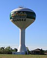
Municipal water tower built in 1999
-
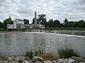
Old Mill Museum in 2008
-
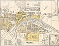
1901 map of Dundee
-
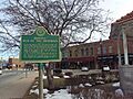
Dundee is known as the "Hub of the Highways"

_(2).jpg)


See also
 In Spanish: Dundee (Míchigan) para niños
