Dundee Township, Michigan facts for kids
Quick facts for kids
Dundee Township, Michigan
|
|
|---|---|

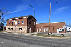
Dundee Township Hall in the village of Dundee
|
|

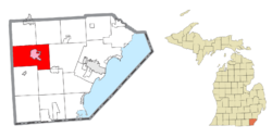
Left: Location within Monroe County (red) and the administered village of Dundee (pink); Right: Location within the state of Michigan
|
|
| Country | United States |
| State | Michigan |
| County | Monroe |
| Established | 1838 |
| Area | |
| • Total | 48.60 sq mi (125.9 km2) |
| • Land | 48.22 sq mi (124.9 km2) |
| • Water | 0.38 sq mi (1.0 km2) |
| Elevation | 666 ft (203 m) |
| Population
(2020)
|
|
| • Total | 8,145 |
| • Density | 168.9/sq mi (65.2/km2) |
| Time zone | UTC-5 (Eastern (EST)) |
| • Summer (DST) | UTC-4 (EDT) |
| ZIP Codes | |
| Area code(s) | 734 |
| FIPS code | 26-115-23400 |
| GNIS feature ID | 1626196 |
Dundee Township is a place in Monroe County, Michigan, in the United States. It is a type of local government area called a civil township. In 2020, about 8,145 people lived there. This was more than the 6,759 people who lived there in 2010. The village of Dundee is inside the township. Most kids in the township go to schools in the Dundee Community Schools system.
Contents
Places in Dundee Township
Dundee Township has a few different communities:
- Diann is a spot where three different railroad lines meet. It's about 3 miles southeast of the village of Dundee.
- Dundee is a village located right in the township. The River Raisin flows through it. Also, two important roads, U.S. Route 23 and M-50, cross paths here.
- Rea is a small community that doesn't have its own local government. It started in 1886 as a train station. Rea even had its own post office for about 20 years.
Where is Dundee Township?
Dundee Township is in the western part of Monroe County. It shares a border with Lenawee County to the west. The village of Dundee is right in the middle of the township. It's about 14 miles west of Monroe, which is the main city of the county.
The River Raisin flows through the township from the south to the east. It goes right through the center of Dundee village. Most of the township's water drains into the River Raisin. However, the southeast part drains into Plum Creek. Both the River Raisin and Plum Creek eventually flow into Lake Erie.
The township covers a total area of about 48.60 square miles. Most of this area, about 48.22 square miles, is land. The rest, about 0.38 square miles, is water.
How Many People Live Here?
| Historical population | |||
|---|---|---|---|
| Census | Pop. | %± | |
| 1850 | 1,239 | — | |
| 1860 | 1,940 | 56.6% | |
| 1870 | 2,384 | 22.9% | |
| 1880 | 3,242 | 36.0% | |
| 1890 | 3,539 | 9.2% | |
| 1900 | 3,061 | −13.5% | |
| 1910 | 2,942 | −3.9% | |
| 1920 | 2,801 | −4.8% | |
| 1930 | 2,955 | 5.5% | |
| 1940 | 3,489 | 18.1% | |
| 1950 | 3,838 | 10.0% | |
| 1960 | 4,511 | 17.5% | |
| 1970 | 4,911 | 8.9% | |
| 1980 | 5,395 | 9.9% | |
| 1990 | 5,376 | −0.4% | |
| 2000 | 6,341 | 18.0% | |
| 2010 | 6,759 | 6.6% | |
| 2020 | 8,145 | 20.5% | |
| U.S. Decennial Census | |||
In 2000, there were 6,341 people living in Dundee Township. There were 2,367 households, which are groups of people living together. About 36.4% of these households had children under 18 years old.
The people living in the township are of different ages. About 28.2% were under 18 years old. About 9.4% were between 18 and 24 years old. The largest group, 30.3%, was between 25 and 44 years old. About 9.6% of the people were 65 years or older. The average age in the township was 34 years old.
Roads and Highways
These are the main roads that go through Dundee Township:
 US 23
US 23 M-50
M-50
See also
 In Spanish: Municipio de Dundee (Míchigan) para niños
 | Janet Taylor Pickett |
 | Synthia Saint James |
 | Howardena Pindell |
 | Faith Ringgold |


