Raisin River (Ontario) facts for kids
Quick facts for kids Raisin River |
|
|---|---|

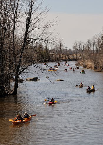
Annual canoe race on the Raisin River
|
|
|
Location of the mouth of the Raisin River in Ontario
|
|
| Country | Canada |
| Province | Ontario |
| Region | Eastern Ontario |
| County | United Counties of Stormont, Dundas and Glengarry |
| Municipalities |
|
| Physical characteristics | |
| Main source | Field Newington, South Stormont 96 m (315 ft) 45°06′55″N 75°02′34″W / 45.11528°N 75.04278°W |
| River mouth | Lake Saint Francis Lancaster, South Glengarry 43 m (141 ft) 45°07′35″N 74°29′31″W / 45.12639°N 74.49194°W |
| Basin features | |
| River system | Saint Lawrence River drainage basin |
| Basin size | 57.982 km2 (22.387 sq mi) |
| Tributaries |
|
The Raisin River is a cool river located in Eastern Ontario, Canada. It flows through areas like South Stormont and South Glengarry. The river's watershed, which is the land area that drains into the river, also includes parts of North Stormont, North Glengarry, and the city of Cornwall. The Raisin River eventually flows into Lake Saint Francis, which is part of the big Saint Lawrence River. This happens near the town of Lancaster.
The name "Raisin River" comes from the French phrase "la rivière aux Raisins." In French, "raisins" means grapes. This name was given by early French settlers because they found lots of wild grapes growing along the riverbanks. You can still find these wild grapes there today!
Contents
Where Does the Raisin River Flow?
The Raisin River starts its journey in a field. This spot is about 2 kilometers (1.2 miles) west of a community called Newington. From there, it travels south towards Bunker Hill.
How Does the River's Path Change?
After Bunker Hill, the river turns east. It picks up water from smaller streams, called tributaries, along the way. These include Palen Creek, Shaver Drain, and Wereley Creek, all joining from the left side near North Lunenburg.
The Raisin River keeps heading east. It meets Stoney Creek, another left-side tributary, near the community of Black River. Then, it flows under Ontario Highway 138 at St. Andrews.
What Happens Further Downstream?
The river then turns northeast. It takes in Beaver Creek from the left and McIntosh Drain from the right. After that, the North Raisin River joins from the left at Martintown.
The Raisin River continues its eastward path and enters South Glengarry. Here, Glen Falloch Drain joins from the right and McIntyre Creek from the left. The river then reaches the town of Williamstown, where the South Raisin River adds its waters from the right.
Finally, the river flows east again, taking in Glen Drain from the right. It passes under Ontario Highway 401 before reaching its end at Lake Saint Francis.
Fun Activities on the Raisin River
The Raisin River is a great place for outdoor activities!
What Races Happen on the River?
There are two popular races held near or on the Raisin River.
- The "Great Raisin River Foot Race" is a running event that takes place in Williamstown.
- Every spring, the "Raisin River Canoe Race" is held. People paddle canoes from Saint Andrews all the way to Williamstown. It's a fun and challenging event!
What Are the Raisin River's Tributaries?
Tributaries are smaller streams or rivers that flow into a larger river. The Raisin River has several tributaries that help feed its waters.
- Glen Drain (joins from the right side)
- South Raisin River (joins from the right side)
- McIntyre Creek (joins from the left side)
- Glen Falloch Drain (joins from the right side)
- North Raisin River (joins from the left side)
- McIntosh Drain (joins from the right side)
- Beaver Creek (joins from the left side)
- Stoney Creek (joins from the left side)
- Wereley Creek (joins from the left side)
- Shaver Drain (joins from the left side)
- Palen Creek (joins from the left side)
 | Victor J. Glover |
 | Yvonne Cagle |
 | Jeanette Epps |
 | Bernard A. Harris Jr. |


