South Rockwood, Michigan facts for kids
Quick facts for kids
South Rockwood, Michigan
|
|
|---|---|
|
Village
|
|

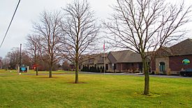
South Rockwood Village Hall
|
|

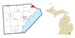
Location within Monroe County and the state of Michigan
|
|
| Country | United States |
| State | Michigan |
| County | Monroe |
| Township | Berlin |
| Founded | 1863 |
| Incorporated | 1955 |
| Government | |
| • Type | Village council |
| Area | |
| • Total | 3.33 sq mi (8.62 km2) |
| • Land | 3.27 sq mi (8.47 km2) |
| • Water | 0.06 sq mi (0.16 km2) |
| Elevation | 587 ft (179 m) |
| Population
(2020)
|
|
| • Total | 1,587 |
| • Density | 484.58/sq mi (187.11/km2) |
| Time zone | UTC-5 (Eastern (EST)) |
| • Summer (DST) | UTC-4 (EDT) |
| ZIP Code |
48179
|
| Area code(s) | 734 |
| FIPS code | 26-75280 |
| GNIS feature ID | 0638409 |
South Rockwood is a small village in Monroe County, Michigan. In 2020, about 1,587 people lived there. The village is part of Berlin Charter Township.
Contents
History of South Rockwood
South Rockwood was started in 1863 by a person named John Strong. He named the community after Rockwood, Ontario. Another nearby town, Rockwood, was settled a few years earlier. John Strong opened the South Rockwood post office on July 5, 1877. The community officially became a village in 1955.
Geography and Location
South Rockwood is in the northeast part of Monroe County. It is also in the northern area of Berlin Charter Township. The Huron River forms the northern border of the village. This river also marks the county line with Wayne County. The city of Rockwood is just north of the river.
Land and Water Area
The village covers a total area of about 3.33 square miles (8.62 square kilometers). Most of this area, about 3.27 square miles (8.47 square kilometers), is land. The rest, about 0.06 square miles (0.16 square kilometers), is water.
Main Roads
- I-75 is a major highway that goes through the middle of the village. You can get on I-75 at exit 26, which is South Huron River Drive.
- This highway leads northeast to Detroit, which is about 25 miles away.
- It also goes southwest to Toledo, Ohio, about 33 miles away.
- Monroe, the main city in Monroe County, is about 13 miles southwest.
Population and People
| Historical population | |||
|---|---|---|---|
| Census | Pop. | %± | |
| 1880 | 251 | — | |
| 1960 | 1,337 | — | |
| 1970 | 1,477 | 10.5% | |
| 1980 | 1,353 | −8.4% | |
| 1990 | 1,221 | −9.8% | |
| 2000 | 1,284 | 5.2% | |
| 2010 | 1,675 | 30.5% | |
| 2020 | 1,587 | −5.3% | |
| U.S. Decennial Census | |||
Village Population in 2010
In 2010, there were 1,675 people living in South Rockwood. They lived in 687 households. About 453 of these were families. The village had about 713 people per square mile.
Most residents were White (95.4%). A smaller number were African American (2.3%), Native American (0.2%), or Asian (0.4%). Some people were from other races or had mixed backgrounds. About 4.1% of the population was Hispanic or Latino.
Households and Families
About 30% of households had children under 18 living with them. Many households (50.4%) were married couples. Some households had a female head (11.5%) or a male head (4.1%) without a spouse. About 25.6% of households were single people living alone. The average household had 2.44 people. The average family had 2.95 people.
Age of Residents
The average age in the village was 38.9 years old.
- 20.8% of residents were under 18.
- 8.9% were between 18 and 24.
- 29% were between 25 and 44.
- 31.1% were between 45 and 64.
- 10.1% were 65 or older.
The village had slightly more males (50.7%) than females (49.3%).
Education
The schools in South Rockwood are part of the Airport Community Schools district.
See also
 In Spanish: South Rockwood para niños
 | Janet Taylor Pickett |
 | Synthia Saint James |
 | Howardena Pindell |
 | Faith Ringgold |


