Lambertville, Michigan facts for kids
Quick facts for kids
Lambertville, Michigan
|
|
|---|---|

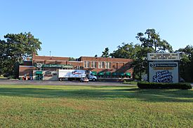
Olde Schoolhouse Commons
|
|

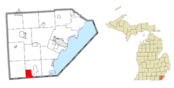
Location within Monroe County
|
|
| Country | United States |
| State | Michigan |
| County | Monroe |
| Township | Bedford |
| Area | |
| • Total | 6.75 sq mi (17.48 km2) |
| • Land | 6.74 sq mi (17.46 km2) |
| • Water | 0.01 sq mi (0.02 km2) |
| Elevation | 669 ft (204 m) |
| Population
(2020)
|
|
| • Total | 10,433 |
| • Density | 1,547.69/sq mi (597.59/km2) |
| Time zone | UTC-5 (Eastern (EST)) |
| • Summer (DST) | UTC-4 (EDT) |
| ZIP code(s) |
48144
|
| Area code(s) | 734 |
| FIPS code | 26-45420 |
| GNIS feature ID | 0630097 |
Lambertville is a community in Monroe County, Michigan, in the United States. It is an unincorporated community. It is also a census-designated place (CDP). This means the U.S. Census Bureau counts its population.
In 2020, about 10,433 people lived in Lambertville. The community is part of Bedford Township. The local ZIP Code, 48144, covers Lambertville. It also serves parts of Bedford Township and Whiteford Township.
Contents
History of Lambertville
Lambertville was settled a long time ago, around 1832. A person named John Lambert helped start the community.
Early Post Office and Name Change
On June 13, 1834, a post office opened here. It was first called West Erie. This name came from its location in Erie Township. It was west of Erie.
The post office's name changed to Lambertville on January 15, 1836. This happened when Bedford Township was created. The post office closed for a short time in 1865. But it has been open ever since.
Geography of the Area
Lambertville is located in Monroe County, Michigan. It covers a total area of about 6.75 square miles (17.48 square kilometers).
Most of this area is land. Only a very small part, about 0.01 square miles (0.02 square kilometers), is water.
Population and People
The number of people living in Lambertville has grown over the years.
| Historical population | |||
|---|---|---|---|
| Census | Pop. | %± | |
| 1990 | 7,860 | — | |
| 2000 | 9,299 | 18.3% | |
| 2010 | 9,953 | 7.0% | |
| 2020 | 10,433 | 4.8% | |
| U.S. Decennial Census | |||
In 2000, there were 9,299 people living here. There were 3,315 households. Many families lived together. About 38.6% of households had children under 18.
The population includes people of all ages. About 28.1% were under 18 years old. About 10.1% were 65 years or older. The average age was 38 years.
Notable People from Lambertville
Some well-known people have connections to Lambertville:
- Leo Marentette: A former professional baseball player. He lived in Lambertville when he passed away.
- Roy Parmelee: Another professional baseball player. He was born in Lambertville.
- Jim Long: A former crew chief in NASCAR, a popular car racing sport. Lambertville is listed as his hometown.
Images for kids
See also
 In Spanish: Lambertville (Míchigan) para niños


