Sandy Creek (Michigan) facts for kids
Quick facts for kids Sandy Creek |
|
|---|---|

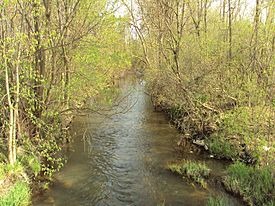
View from Dixie Highway in Frenchtown Township
|
|
|
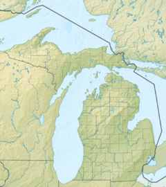
Location within the state of Michigan
|
|
| Country | United States |
| State | Michigan |
| County | Monroe |
| Physical characteristics | |
| Main source | London Township 663 ft (202 m) 42°01′48″N 83°35′31″W / 42.03000°N 83.59194°W |
| River mouth | Lake Erie Frenchtown Charter Township 571 ft (174 m) 41°55′30″N 83°20′02″W / 41.92500°N 83.33389°W |
| Length | 18.5 mi (29.8 km) |
| Basin features | |
| Tributaries |
|
Sandy Creek is a creek in Monroe County, Michigan. It is about 18.5-mile-long (29.8 km). The creek starts in London Township in the northern part of the county. It then flows southeast into Lake Erie in Frenchtown Charter Township. The creek's mouth is near Sterling State Park.
Long ago, one of the first French settlements in the area was along Sandy Creek. It was called the Sandy Creek Settlement. This settlement was active from about 1780 to 1813. It was left empty after the Battle of Frenchtown during the War of 1812.
Contents
About Sandy Creek's Geography
Sandy Creek is a very narrow and shallow creek. It does not have any dams and boats cannot travel on it. However, the area of land that drains into the creek, called its watershed, is very important. It helps prevent floods in the area. This region is mostly flat and has a lot of farms.
In 2019, a big project costing $1.2 million helped the creek. Workers removed many trees and plants along its banks. This was done to help the creek drain water better. It helps stop flooding along its path.
Where Does Sandy Creek Flow?
Sandy Creek's watershed covers parts of several townships and cities. These include Frenchtown Charter Township, Raisinville Township, and Exeter Township. It also includes the village of Maybee, London Township, and Dundee Township. The city of Monroe is also part of its watershed.
The creek flows for 18.5 miles (29.8 km) from London Township to Lake Erie. Sterling State Park is south of where the creek meets the lake. The community of Detroit Beach is to the north. Stone walls and a pump station were built in Detroit Beach. These help stop flooding from Sandy Creek and high water from Lake Erie.
Sandy Creek's Tributaries and Crossings
Sandy Creek has one main tributary (a smaller stream that flows into it). This is called Little Sandy Creek. It flows about one mile south of the main creek. Sandy Creek flows under several major roads. These include Interstate 75, U.S. Route 24 (North Telegraph Road), and North Monroe Street (M-125).
Fish in Sandy Creek
Sandy Creek itself does not have many large fish. Most fish are found in the larger, man-made lagoons of Sterling State Park. These lagoons lead to Lake Erie. Common fish in this area include perch, walleye, and crappie. You can also find channel and bullhead catfish. Other fish include largemouth and white bass, carp, northern pike, and bluegill.
History of the Sandy Creek Settlement

Near Lake Erie, along the banks of Sandy Creek, was one of the first European settlements in the area. It was known as the Sandy Creek Settlement. This small settlement was started by the French around 1780. This was a few years before the larger Frenchtown settlement began in 1784. Frenchtown was located just south near the River Raisin.
At that time, the area was controlled by the British Province of Quebec. It was before American control. In 1787, the area became part of the new American Northwest Territory. Later, it was briefly part of the Indiana Territory in 1800. Finally, it became part of the Michigan Territory in 1805.
Life in the Settlement
The Potawatomi tribe, who lived there first, gave the land for the Sandy Creek Settlement to the early French settlers. The small settlement of Sandy Creek grew to only a few dozen people. It was left empty in 1813. This happened after the Americans lost a major battle at the Battle of Frenchtown during the War of 1812. The Sandy Creek Settlement was abandoned during this battle and was never settled again.
Today, there are no signs left of the Sandy Creek Settlement. Parts of Frenchtown later became part of the city of Monroe. The Sandy Creek Settlement is now part of the River Raisin Heritage Corridor. It is a key part of the River Raisin National Battlefield Park.
Remembering the Settlement
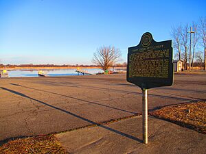
The history of the settlement is told on a historic marker. The Monroe County Historical Commission put up this marker. It is near the boat launch in Sterling State Park. The historic marker says:
- Joseph Porlier Benec, Sandy Creek's first settler, was granted a tract of land here by the Pottawatomie Indians, August 3, 1780. By the time of the War of 1812, sixteen homes lined the banks of the creek. Retreating Indians swept through the settlement after the defeat of the British and Indians at the first Battle of the River Raisin, January 18, 1813. Angered by the pro-American remarks of Jean Solo and Rene LaBeau, these Indians shot them. LaBeau's frightened young children ran two and a half miles to the River Raisin, seeking the protection of the American Army. The Americans ordered the Sandy Creek settlement abandoned and it never completely rebuilt.
 | Toni Morrison |
 | Barack Obama |
 | Martin Luther King Jr. |
 | Ralph Bunche |


