
Frenchtown Charter Township, Michigan facts for kids
Quick facts for kids
Frenchtown Township, Michigan
|
|
|---|---|
|
Charter township
|
|
| Frenchtown Charter Township | |

Frenchtown Township Hall
|
|

Location within Monroe County and the administered CDPs of Detroit Beach (1), Stony Point (2), and Woodland Beach (3)
|
|

Frenchtown Township, Michigan
Location in Michigan

Frenchtown Township, Michigan
Location in the United States
|
|
| Country | United States |
| State | Michigan |
| County | Monroe |
| Settled | 1784 |
| Organized | 1837 |
| Area | |
| • Total | 43.12 sq mi (111.7 km2) |
| • Land | 41.74 sq mi (108.1 km2) |
| • Water | 1.38 sq mi (3.6 km2) |
| Elevation | 594 ft (181 m) |
| Population
(2020)
|
|
| • Total | 21,609 |
| • Density | 517.7/sq mi (199.9/km2) |
| Time zone | UTC-5 (Eastern (EST)) |
| • Summer (DST) | UTC-4 (EDT) |
| ZIP Codes | |
| Area code | 734 |
| FIPS code | 26-115-30820 |
| GNIS feature ID | 1626321 |
Frenchtown Charter Township is a special kind of town area, called a charter township, in Monroe County, Michigan. In 2020, about 21,609 people lived here.
The city of Monroe is right next to Frenchtown Township on its southern side. You can find Sterling State Park and the Enrico Fermi Nuclear Generating Station (a power plant) inside the township. Frenchtown was also the location of an important battle during the War of 1812, called the Battle of Frenchtown.
Contents
History of Frenchtown Township

This area was first home to Native American tribes, like the Potawatomi. They traded with French-Canadian settlers who arrived here. The first European settlers were French Canadians who started living along the River Raisin in 1784. These settlers were part of a larger group of French colonists in the Detroit area.
The United States gained control of this land after the Treaty of Paris (1783), which ended the American Revolutionary War. Over time, the area became part of different territories before finally joining the State of Michigan in 1837.
The War of 1812 Battle
During the War of 1812, a big battle happened here called the Battle of Frenchtown. It was a very tough fight where many American soldiers lost their lives. Today, this historic battlefield is part of the River Raisin National Battlefield Park, which was created in 2009. This park is now within the city limits of Monroe.
How Frenchtown Became a Township
In 1817, a part of Frenchtown was renamed and became the village of Monroe. This was done to honor President James Monroe who planned to visit the area. Monroe became the main town (county seat) for the new Monroe County.
When Monroe officially became a city in 1837, the rest of the Frenchtown area was organized into a township. This new township covered a large northern part of the county. Later, some parts of Frenchtown Township were separated to form other townships, like Ash Township and Berlin Charter Township. Also, the city of Monroe grew and took over some parts of southern Frenchtown over the years. That's why the border between Frenchtown Township and the city of Monroe looks a bit zig-zaggy today!
Communities in Frenchtown Township
Frenchtown Township is home to several smaller communities:
- Brest was an old port town on Lake Erie. French settlers started it around 1810. It was named after Brest, France. It had a post office for a while, but the port didn't succeed. You can still see Brest on old maps near what is now Stony Point.
- Detroit Beach is a community where people live, located near the lake.
- Golfcrest is another community within the township.
- Loranger was a small settlement that grew around a gristmill (a mill for grinding grain) in 1832. The mill was later moved to The Henry Ford museum. The Edward Loranger House, built in 1825, is still there today.
- Newport is a community mostly in Berlin Township, but its ZIP Code also covers the northern part of Frenchtown Township.
- Pointe aux Peaux is a community located close to Stony Point, right by the shores of Lake Erie.
- Steiner is a community that used to have its own post office for many years.
- Stony Creek is a historic community located along a railway line. It had a post office for a very short time.
- Stony Point is a community and a census-designated place near Lake Erie.
- Woodland Beach is another community and census-designated place in the township.
Geography and Nature

Frenchtown Township is in the eastern part of Monroe County, with Lake Erie forming its southeastern border. Many communities in the township are located close to the lake. Sterling State Park is a beautiful park right on Lake Erie, and most of it is inside Frenchtown Township. Parts of the township are also part of the Detroit River International Wildlife Refuge, which protects animals and their homes.
The city of Monroe is to the south of Frenchtown Township. Other nearby townships include Raisinville Township to the west, and Ash and Berlin Township to the north. The River Raisin forms a small part of the border with Monroe. Another creek, Sandy Creek, also flows through the township. The lowest point in Michigan is along the Lake Erie shoreline in Frenchtown Township, which is about 571 feet (174 meters) above sea level.
The township covers about 43.12 square miles (111.68 square kilometers) in total. Most of this area, about 41.74 square miles (108.11 square kilometers), is land. The rest, about 1.38 square miles (3.57 square kilometers), is water.
Main Roads and Highways
Several important roads run through Frenchtown Township:
 I-75 is a major highway that goes through the middle of the township.
 I-275 starts its journey south in Frenchtown Township.
 US 24 (North Telegraph Road) runs next to Interstate 75.
 US 25 was an older highway that used to go through the township.
- M-125 (North Monroe Street) also runs through the township.
 M-130 (North Custer Road) was a state highway here from 1929 to 1955.
- M-56 (North Dixie Hwy) was another older highway that ran north-south near Lake Erie.
Population and People
| Historical population | |||
|---|---|---|---|
| Census | Pop. | %± | |
| 1850 | 1,242 | — | |
| 1860 | 1,777 | 43.1% | |
| 1870 | 2,115 | 19.0% | |
| 1880 | 2,485 | 17.5% | |
| 1890 | 2,023 | −18.6% | |
| 1900 | 1,938 | −4.2% | |
| 1910 | 1,770 | −8.7% | |
| 1920 | 1,840 | 4.0% | |
| 1930 | 2,560 | 39.1% | |
| 1940 | 3,757 | 46.8% | |
| 1950 | 6,966 | 85.4% | |
| 1960 | 12,199 | 75.1% | |
| 1970 | 14,685 | 20.4% | |
| 1980 | 18,204 | 24.0% | |
| 1990 | 18,210 | 0.0% | |
| 2000 | 20,777 | 14.1% | |
| 2010 | 20,428 | −1.7% | |
| 2020 | 21,609 | 5.8% | |
| U.S. Decennial Census | |||
In 2010, there were 20,428 people living in Frenchtown Township. Most people living here were White (95.51%). There were also African American, Native American, Asian, and other groups. About 2.45% of the population identified as Hispanic or Latino.
The average household had about 2.65 people, and the average family had about 3.10 people. The median age of people in the township was 34 years old.
Education
Students in Frenchtown Township attend schools in three different public school districts:
- Most of the township is served by Jefferson Schools. Their middle school and high school are located within Frenchtown Township.
- The northern part of the township is served by Airport Community Schools.
- The western part of the township is served by Monroe Public Schools.
There is also a charter school called Triumph Academy located in the township.
Images for kids
-
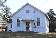
Library and former town hall, built 1910 -
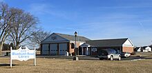
Bluebush Road Library & Fire Station -
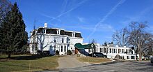
Monroe Golf & Country Club, built 1919


See also
 In Spanish: Municipio de Frenchtown (Míchigan) para niños
