Raisinville Township, Michigan facts for kids
Quick facts for kids
Raisinville Township, Michigan
|
|
|---|---|

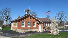
Raisinville Township Hall
|
|

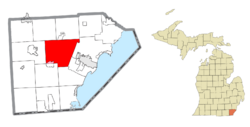
Location within Monroe County and the state of Michigan
|
|
| Country | United States |
| State | Michigan |
| County | Monroe |
| Organized | 1823 |
| Area | |
| • Total | 48.54 sq mi (125.72 km2) |
| • Land | 48.14 sq mi (124.68 km2) |
| • Water | 0.40 sq mi (1.04 km2) |
| Elevation | 630 ft (192 m) |
| Population
(2020)
|
|
| • Total | 5,903 |
| • Density | 122.6/sq mi (47.3/km2) |
| Time zone | UTC-5 (Eastern (EST)) |
| • Summer (DST) | UTC-4 (EDT) |
| ZIP Code | |
| Area code(s) | 734 |
| FIPS code | 26-115-66900 |
| GNIS feature ID | 1626951 |
Raisinville Township is a community in Monroe County, Michigan, USA. In 2020, about 5,903 people lived here. It is known for its history and various small communities.
Contents
A Look Back: Raisinville Township's History
Raisinville Township was first set up in 1823. This was when Michigan was still a territory, not yet a state. Riley Ingersoll, one of the first people to settle there, became the first leader of the township. Over time, parts of Raisinville Township were used to create other townships nearby.
The Historic Bridge School
The Bridge School is very important to Michigan's history. It opened in 1828 and was the first public school in the Michigan Territory. It taught students until 1946. After it closed, the building was given to the township. Since 1982, it has been used as the township hall, where local government meetings happen. The Bridge School was recognized as a special Michigan State Historic Site in 1987.
Remembering Comair Flight 3272
On January 9, 1997, a sad event happened in Raisinville Township. Comair Flight 3272 crashed into a corn field. The plane was an Embraer EMB 120 Brasilia. It crashed because of icy weather conditions. All 26 passengers and three crew members on board lost their lives.
Exploring Raisinville Township's Communities
Raisinville Township is home to several smaller communities, each with its own story.
- East Raisinville was a settlement in the eastern part of the township. It had a post office called "Atkinson" that opened in 1829. It was later renamed East Raisinville.
- Grape is a small, unincorporated community in the middle of the township. It's located along North Custer Road. This community had its own post office from 1887 to 1906. The name "Grape" comes from the French word for "raisin," which is part of the township's name.
- Hamlin was another community along the railway line. It was named after Hannibal Hamlin, who was a vice president at the time. Hamlin had a post office that later moved to Raisinville.
- Ida is a community mostly located just south of Raisinville Township. However, a small part of Ida extends into Raisinville Township. The Ida ZIP Code (48140) serves some areas within Raisinville.
- North Raisinville was a settlement in the northern part of the township. It was first called "Taylorsville" after Amos Taylor, its first postmaster. It was renamed North Raisinville in 1838.
- Raisinville was the very first settlement in the township, started in 1822. The community and the township are named after the River Raisin. It had a post office that opened and closed a few times, sometimes called "West Raisinville."
- Strasburg is a community in the southeast part of the township. It was settled in 1828, known for its lime kilns. It also had a post office that operated at different times.
Geography and Natural Features
Raisinville Township is in the center of Monroe County. It sits between the city of Monroe (the county seat) to the southeast and Dundee to the west. The township covers about 48.54 square miles (125.72 square kilometers). Most of this area is land, with a small amount of water.
Rivers and Creeks
The River Raisin flows right through the middle of the township. Another waterway, Sandy Creek, runs through the northeast part of the area.
Main Roads for Travel
- M-50 (South Custer Road) is a major road that goes from west to east through the center of the township.
 M-130 (North Custer Road) was once a state highway from 1929 to 1955.
Education in Raisinville Township
Students in Raisinville Township attend schools in three different public school districts.
- The northeastern part of the township is served by Monroe Public Schools. Raisinville Elementary School, the only public school building in the township, is part of this district.
- The southern half of the township is served by Ida Public Schools.
- The northwest corner of the township is served by Dundee Community Schools.
Population and People
Raisinville Township has grown steadily over the years. In 1850, about 967 people lived here. By 2020, the population had grown to 5,903 people.
| Historical population | |||
|---|---|---|---|
| Census | Pop. | %± | |
| 1850 | 967 | — | |
| 1860 | 1,448 | 49.7% | |
| 1870 | 1,793 | 23.8% | |
| 1880 | 2,035 | 13.5% | |
| 1890 | 1,830 | −10.1% | |
| 1900 | 1,811 | −1.0% | |
| 1910 | 1,693 | −6.5% | |
| 1920 | 1,541 | −9.0% | |
| 1930 | 1,840 | 19.4% | |
| 1940 | 1,990 | 8.2% | |
| 1950 | 2,225 | 11.8% | |
| 1960 | 3,277 | 47.3% | |
| 1970 | 4,009 | 22.3% | |
| 1980 | 4,797 | 19.7% | |
| 1990 | 4,634 | −3.4% | |
| 2000 | 4,896 | 5.7% | |
| 2010 | 5,816 | 18.8% | |
| 2020 | 5,903 | 1.5% | |
| U.S. Decennial Census | |||
In 2000, there were 4,896 people living in the township. About 1,691 households were counted. The average household had about 2.88 people. Many households were made up of married couples. About 26.6% of the population was under 18 years old. The median age was 38 years.
See also
 In Spanish: Municipio de Raisinville para niños
 | Sharif Bey |
 | Hale Woodruff |
 | Richmond Barthé |
 | Purvis Young |


