
Maybee, Michigan facts for kids
Quick facts for kids
Maybee, Michigan
|
|
|---|---|
|
Village
|
|

Looking east along Bluebush Road
|
|
| Motto(s):
"The Best Little Town in Michigan"
|
|

Location within Monroe County and the state of Michigan
|
|

Maybee, Michigan
Location in Michigan

Maybee, Michigan
Location in the United States
|
|
| Country | United States |
| State | Michigan |
| County | Monroe |
| Township | Exeter |
| Established | 1873 |
| Incorporated | 1899 |
| Government | |
| • Type | Village council |
| Area | |
| • Total | 1.86 sq mi (4.82 km2) |
| • Land | 1.84 sq mi (4.77 km2) |
| • Water | 0.01 sq mi (0.05 km2) |
| Elevation | 636 ft (194 m) |
| Population
(2020)
|
|
| • Total | 545 |
| • Density | 295.55/sq mi (114.11/km2) |
| Time zone | UTC-5 (Eastern (EST)) |
| • Summer (DST) | UTC-4 (EDT) |
| ZIP Codes |
48159
48162 (Monroe) |
| Area code(s) | 734 |
| FIPS code | 26-52440 |
| GNIS feature ID | 631766 |
Maybee (pronounced "may-BEE") is a small village located in Monroe County, in the U.S. state of Michigan. In 2020, 545 people lived there. The village is part of Exeter Township. Maybee was started in 1873 and officially became a village in 1899.
Contents
History of Maybee
Maybee began in 1873 in the southwest part of Exeter Township. This happened when the Canada Southern Railway built a train track through the area. Soon after, the Detroit, Toledo and Ironton Railroad took over the line. They used it to transport things like charcoal and other wood products from Maybee to Detroit and Ohio.
The community was named after an early settler, Abram Maybee. He and Joseph Klotz helped measure and sell the land by 1875. The village grew to have a place to store grain (a grain elevator), a mill for grinding grain (a gristmill), a stone quarry, and a sand pit. It also had a hotel, churches, schools, and many small factories and shops. Because more people moved there, Maybee officially became a village in 1899.
The old Maybee train station is no longer there, but the train tracks still run through the village. The Canadian National Railway now operates the line.
Maybee got its first post office on February 24, 1874. This office closed in 1972. A new post office opened on August 1, 1903, and it is still open today at 7580 Mill Street.
The London–Maybee–Raisinville Volunteer Fire Department started in 1952. It helps keep the village and nearby areas safe. The fire station is at 8755 Baldwin Road.
Maybee has two active cemeteries on Raisin Street. The Northside Cemetery and Saint Joseph Cemetery are both inside the village. The North Side Cemetery has graves from 1876, and the Saint Joseph Cemetery has graves from 1871.
The village borders stayed the same from 1899 until 2013. That year, Maybee gained about 546 acres (2.2 square kilometers) of land from the Stoneco Quarry, which is just north of the village. The village offices are now at 9043 Raisin Street, next to the Maybee Village Hall. The historic hall was built in 1912. It used to hold the village government offices and the fire station until 1977. This building was recognized as a Michigan State Historic Site in 1988. Since March 2021, the building has been used by the Monroe County Police Department as a sheriff's substation.
Geography of Maybee
Maybee is in a rural area in northern Monroe County, in the southwest part of Exeter Township. It is about 10 miles (16 km) northwest of Monroe, which is the main city of the county. It is also about 9 miles (14 km) northeast of Dundee.
The village covers a total area of about 1.86 square miles (4.82 square kilometers). Most of this is land, with a very small amount of water.
The Robert Drain flows through the northern part of the village. It helps water drain into Stony Creek. The Antes Drain flows through the southern part of the village and connects to Sandy Creek. Both Stony Creek and Sandy Creek flow into Lake Erie.
Maybee has its own post office with the ZIP Code 48159. This post office serves a larger area than just the village. It includes parts of Exeter Township, London Township, Milan Township, and small parts of Dundee Township and Raisinville Township. A small part of the village in the southwest uses the Monroe 48162 ZIP Code.
Other nearby villages include Carleton to the northeast and Dundee to the southwest. Maybee is located roughly halfway between the cities of Milan (to the northwest) and Monroe (to the southeast). The small community of Scofield is about one mile (1.6 km) northeast of Maybee.
Education in Maybee
There are no schools directly inside Maybee village. Even though it's a small village, students from Maybee attend schools in two different school districts. Most of the village is served by Monroe Public Schools. A smaller part of the village, west of Baldwin Road, is served by Dundee Community Schools.
Population of Maybee
| Historical population | |||
|---|---|---|---|
| Census | Pop. | %± | |
| 1880 | 200 | — | |
| 1910 | 310 | — | |
| 1920 | 290 | −6.5% | |
| 1930 | 346 | 19.3% | |
| 1940 | 390 | 12.7% | |
| 1950 | 428 | 9.7% | |
| 1960 | 459 | 7.2% | |
| 1970 | 485 | 5.7% | |
| 1980 | 490 | 1.0% | |
| 1990 | 500 | 2.0% | |
| 2000 | 505 | 1.0% | |
| 2010 | 562 | 11.3% | |
| 2020 | 545 | −3.0% | |
| U.S. Decennial Census | |||
As of the 2010 census, 562 people lived in Maybee. There were 205 households, and 154 of them were families. Most of the people living in Maybee were White (96.6%). About 31% of the people were under 18 years old. The average age in the village was about 34.9 years.
Images for kids
| Maybee Village Hall | |
|---|---|
 |
|
| Location | 9051 Raisin Street |
| Built | 1912 |
| Designated | March 15, 1988 |
-
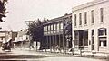
Main Street in 1910
-
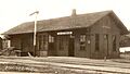
The former Maybee Station
.jpg)
.jpg)
-
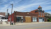
Current village hall -
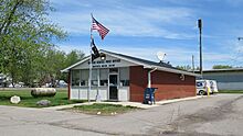
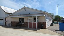
U.S. post office in Maybee -
Monroe County Library branch in Maybee -
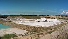
Stoneco Quarry
.jpg)
.jpg)


See also
 In Spanish: Maybee para niños
